Related Research Articles

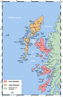
The Outer Hebrides or Western Isles, sometimes known as Na h-Innse Gall or the Long Isle/Long Island, is an island chain off the west coast of mainland Scotland. The islands are geographically coextensive with Comhairle nan Eilean Siar, one of the 32 unitary council areas of Scotland. They form part of the archipelago of the Hebrides, separated from the Scottish mainland and from the Inner Hebrides by the waters of the Minch, the Little Minch, and the Sea of the Hebrides. Scottish Gaelic is the predominant spoken language, although in a few areas English speakers form a majority.

Harris is the southern and more mountainous part of Lewis and Harris, the largest island in the Outer Hebrides, Scotland. Although not an island itself, Harris is often referred to as the Isle of Harris, which is the former postal county and the current post town for Royal Mail postcodes starting HS3 or HS5.

South Uist is the second-largest island of the Outer Hebrides in Scotland. At the 2011 census, it had a usually resident population of 1,754: a decrease of 64 since 2001. The island, in common with the rest of the Hebrides, is one of the last remaining strongholds of the Gaelic language in Scotland. South Uist's inhabitants are known in Gaelic as Deasaich (Southerners). The population is about 90% Roman Catholic.
The flora and fauna of the Outer Hebrides in north west Scotland comprises a unique and diverse ecosystem. A long archipelago, set on the eastern shores of the Atlantic Ocean, it attracts a wide variety of seabirds, and thanks to the Gulf Stream a climate more mild than might be expected at this latitude. Because it is on the Gulf Stream, it also occasionally gets exotic visitors.

South Lewis, Harris and North Uist is a large national scenic area (NSA) in the Western Isles of Scotland. It is one of 40 such areas in Scotland, which are defined so as to identify areas of exceptional scenery and to ensure its protection from inappropriate development. The designated area covers 202,388 ha in total, of which 112,301 ha is on land, with a further 90,087 ha being marine, making it the largest of the NSAs in both total and marine area. The designated area includes the mountainous south west of Lewis, all of Harris, the Sound of Harris and the northern part of North Uist.
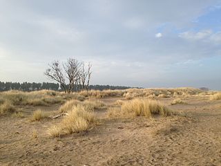
Tentsmuir National Nature Reserve (NNR) is located southeast of Tayport in Fife, Scotland. The reserve is made up of three parts, encompassing Morton Lochs, Tentsmuir Point and Tayport Heath, and is managed by NatureScot. The different sections of Tentsmuir NNR were originally designated as separate national nature reserves at different times: the Morton Lochs section was designated in 1952; Tentsmuir Point in 1954; and Tayport Heath in 1988. While these discrete sections are distant from one another, they form part of the extensive dune system at Tentsmuir, and in 2003 SNH combined the three sites to form Tentsmuir National Nature Reserve. The adjoining Tentsmuir Forest is managed by Forestry and Land Scotland and covers most of the land between the three portions of the NNR.

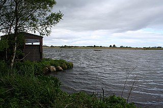
Loch Druidibeag is a freshwater loch situated on the island of South Uist, in the Outer Hebrides of Scotland. The loch is near the northern end of the island, to the north-east of Howmore and to the east of the A865 road and south of the B890.
Bridgend Flats is an area of mudflats and saltmarsh near the village of Bridgend on the island of Islay off the west coast of Scotland. Covering an area of 331 hectares, it is situated around the outflow of the River Sorn into Loch Indaal.

Caithness Lochs is a protected wetland area in the historic county of Caithness in the far north of Scotland. With a total area of 1,379 hectares, it covers six freshwater lochs and a complex area of fen and swamp, and has been protected as a Ramsar Site since 1998.

The Kintyre Goose Roosts are a group of five oligotrophic hill lochs on the Kintyre peninsula in Argyll and Bute, western Scotland. With a total area of 312 hectares, they have been protected as a Ramsar Site since 1998.
The East Sanday Coast is a protected wetland area on and around the island of Sanday, the third-largest of the Orkney islands off the north coast of Scotland. With a total protected area of 1,515 hectares, the 55 kilometre stretch of coast includes rocky and sandy sections, sand dunes, machair habitats, intertidal flats, and saltmarsh. It has been protected as a Ramsar Site since 1997.
Greenlaw Moor is an area of raised heather moorland in the foothills of the Lammermuir Hills, in the Scottish Borders area of Scotland. Located north of the town of Greenlaw and with an area of 248 hectares, the moor has been protected as a Ramsar Site since 1996.

Cairngorm Lochs is a protected wetland area in the Cairngorms, in the Grampian and Highland regions of Scotland. With a total area of 173 hectares, it covers five freshwater lochs which are among the highest areas of standing water in the UK. It has been protected as a Ramsar Site since 1981.

Loch Eye is a shallow freshwater loch, located close to the east coast of Scotland between the Moray Firth, Dornoch Firth and Cromarty Firth. Covering an area of 205 hectares, it is an important site for waterfowl and has been protected since 1986 as a Ramsar Site, a Special Protection Area and a Site of Special Scientific Interest.

Loch of Lintrathen is a man-made loch occupying a glacial basin at the southern end of Glen Isla, approximately 13 kilometres (8.1 mi) west of town of Kirriemuir in Angus, Scotland.

Loch of Kinnordy is a small loch located just west of town of Kirriemuir in Angus, Scotland, which is an important wildlife habitat. The loch itself is approximately 22 hectares, though this has varied over time with drainage attempts and the silting up of the outflow stream. Including surrounding fen, swamp and mire, 85 hectares are protected as a Ramsar Site.
Loch Spynie is a small loch located between the towns of Elgin and Lossiemouth in Moray, Scotland. Close to Spynie Palace, the ancient home of the bishops of Moray, it is an important wildlife habitat which is protected as a Ramsar Site.

South Tayside Goose Roosts is a composite wetland site to the west of Perth in central Scotland, covering a total of 331 hectares, which has been protected as a Ramsar Site since 1993. Incorporating three disconnected sections, separated by several kilometres, the site contains seven freshwater lochs along with other wetland habitats, including one of the largest raised bogs in the region.

The North Uist Machair and Islands is a protected wetland area in the Outer Hebrides of Scotland. A total of 4,705 hectares comprises seven separate areas: four sites on the west and north coasts of North Uist, as well as the whole of the island of Boreray and parts of Berneray and Pabbay in the Sound of Harris. The site primarily contains machair areas, with a range of habitats including sand dunes, acid grassland and freshwater wetlands, including nutrient-rich marshes and fens, wet and dry machair and saltmarsh. It has been protected as a Ramsar Site since 1999.

The South Uist Machair and Lochs is a protected wetland area on the west coast of South Uist in the Outer Hebrides of Scotland. A total of 5,019 hectares contains blanket bog, oligotrophic lochs, wet and dry machair, fresh and saltwater marsh, coastal dunes and sandy and rocky shores. It includes the estuary waters of the Howmore River, as well as Loch Bi and Loch Druidibeg. It has been protected as a Ramsar Site since 1976.
References
- 1 2 "Information Sheet on Ramsar Wetlands: UK Loch an Duin 13029 RIS2006" (PDF). Joint Nature Conservation Committee. Retrieved 1 April 2019.
- 1 2 "Loch an Duin SSSI". Nature Scotland. Retrieved 1 April 2019.
- 1 2 "Loch an Duin". Ramsar Sites Information Service. Retrieved 1 April 2019.
| | This article about a Site of Special Scientific Interest in Scotland is a stub. You can help Wikipedia by expanding it. |