
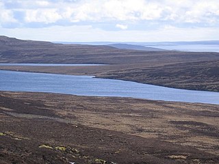
Loch Maree is a loch in Wester Ross in the Northwest Highlands of Scotland. At 21.7 km (13.46 mi) long and with a maximum width of four kilometres, it is the fourth-largest freshwater loch in Scotland; it is the largest north of Loch Ness. Its surface area is 28.7 km2 (11.08 sq mi).
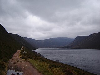
Loch Muick is an upland, freshwater loch lying approximately 5 mi (8.0 km) south of Braemar, Scotland at the head of Glen Muick and within the boundary of the Balmoral estate.

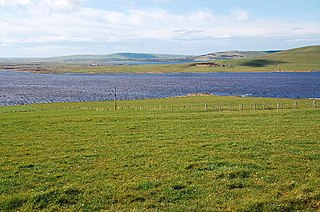
The Loch of Harray is the largest loch of Mainland Orkney, Scotland and is named for the parish of Harray. It lies immediately north of the Loch of Stenness and is close to the World Heritage neolithic sites of the Stones of Stenness and Ring of Brodgar. In Old Norse its name was Heraðvatn.

Loch Gelly is a small loch in Fife, Scotland lying approximately 1.5 km to the south east of the town of Lochgelly which itself is named after the loch. The Gaelic name of the loch, Loch Gheallaidh, can be loosely translated as Loch of Shining Waters or Loch of Brightness. It is a broad, shallow flat bottomed basin approximately 1.75 km in length from west to east and 0.75 km wide at its maximum breadth.
Carlingwark Loch is a small freshwater loch in the historical county of Kirkcudbrightshire, Dumfries and Galloway, Scotland lying just south of Castle Douglas and is roughly rectangular in shape, trending nearly north and south. The name of the loch comes from the Scots Gaelic word Caer meaning fort and wark the old Scots language word for work. There are four artificial islets in the loch showing evidence of fortification and settlement, Ash Island is thought to be a crannog. Several archaeological finds have been retrieved from the loch including a bronze cauldron, sword and pan and two dugout canoes.

The Loch of Boardhouse is a freshwater loch in the parish of Birsay in the north west of the mainland of Orkney, Scotland. It acts as a reservoir for public water supply and is popular for trout fishing. Nearby are the Loch of Hundland and the Loch of Swannay.
The Loch of Bosquoy is a small, shallow, rhomboid shaped loch on Mainland, Orkney, Scotland situated just off the north east corner of the Loch of Harray. The loch was surveyed during 1903 by Sir John Murray and later charted as part of The Bathymetrical Survey of Fresh-Water Lochs of Scotland 1897–1909.

The Loch of Kirbister is a small, shallow, somewhat triangular shaped loch on Mainland Orkney, Scotland, in the parish of Orphir. It lies 5 mi (8.0 km) south west of Kirkwall on cultivated land between two hills. There is a small turf-covered islet known as the Groundwater of Holm just off the eastern shore of the loch. It shows traces in stone of an oval structure and small projecting pier. The loch is popular for trout fishing and the Orkney Trout Fishing Association has a hatchery at the Kirbister pumphouse on the loch edge.

Loch Calder is a lowland freshwater loch lying approximately 5 mi (8.0 km) south west of Thurso in the Scottish Highlands. The loch is large with an irregular shape and has perimeter of 12.8 km (8.0 mi). It is approximately 2.33 mi (3.75 km) long, has an average depth of 21 ft (6.4 m) and is 85 ft (26 m) at its deepest. The loch was surveyed on 6 October 1902 by John Parsons and T.R.H. Garrett and later charted as part of Sir John Murray's Bathymetrical Survey of Fresh-Water Lochs of Scotland 1897-1909.
The Loch of Skaill is a small somewhat triangular, freshwater loch in the parish of Sandwick, Orkney on Mainland Orkney, Scotland. It lies 0.5 mi (0.80 km) south east of the Bay of Skaill close to Skaill House and the World Heritage neolithic site Skara Brae.
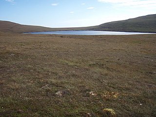
Muckle Water is a long, narrow fresh water loch on Ward Hill on Rousay, Orkney, Scotland. It is the biggest loch on the island and is popular for fishing. It can be reached by a track from the roadside. The Suso Burn on the north eastern shore drains the loch into the Sound of Rousay.
The Loch of Hundland is a shallow freshwater loch in the parish of Birsay in the north west of the mainland of Orkney, Scotland. The loch lies between the larger lochs of Swannay and Boardhouse and acts as the main water catchment for Loch of Boardhouse. It has a great variety of aquatic plants including species that are unusual locally and nationally, and many types of birds including waders, gulls, larks and ducks that nest or use the loch. It is also popular for trout fishing.
Hoglinns Water is a small freshwater loch in the south of the island of Hoy, Orkney. It drains in to Heldale Water via Hoglinns Burn. The loch was surveyed in 1906 by Sir John Murray and later charted as part of the Bathymetrical Survey of Fresh-Water Lochs of Scotland 1897-1909.

Loch na h-Oidhche is a remote freshwater loch lying between Loch Torridon and Loch Maree in the Flowerdale Forest, Wester Ross, Scotland. It is approximately 4.5 mi (7.2 km) north of the small village of Torridon and 8 mi (13 km) southeast of Gairloch.
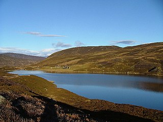
Loch Callater is an upland, freshwater loch lying approximately 5 miles (8 km) south of Braemar, Scotland. The loch trends in a northwest to southeast direction and is surrounded on both sides by steep hills. It is approximately 1.6 km (1 mi) in length.

Loch of Tankerness is a large, lowland, freshwater loch on the Orkney mainland in Scotland. The loch is roughly triangular in shape and is shallow with a flat bottom that gradually deepens from west to east. It lies approximately 4 mi (6.4 km) southeast of Kirkwall.

Loch Dornal is an irregular shaped, shallow, freshwater loch in south Ayrshire, in the Southern Uplands of Scotland. It lies approximately eight miles northwest of the town of Newton Stewart.
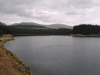
Kirriereoch Loch is a small, shallow, square shaped, freshwater loch in Dumfries and Galloway, in the Southern Uplands of south-west Scotland. It lies approximately 12 mi (19 km) north of the town of Newton Stewart. It is a part of the Wood of Cree Nature Preserve system

Loch Shurrery is a small, shallow, lowland freshwater loch lying approximately 8 mi (13 km) south west of Thurso in the Scottish Highlands. The loch has a somewhat elliptical shape with a perimeter of 7.4 km (4.6 mi). It is approximately 1.25 mi (2.01 km) long, has an average depth of 4.5 ft (1.4 m) and is 7 ft (2.1 m) at its deepest. The loch was surveyed on 6 October 1902 by John Parsons and T.R.H. Garrett and later charted as part of Sir John Murray's Bathymetrical Survey of Fresh-Water Lochs of Scotland 1897-1909. A dam lies to the north end of the loch.

Loch Teàrnait, also known as Loch Tearnait or Loch Ternate, is a small, lowland, freshwater loch on the Ardtornish Estate on the Morvern peninsula in the Scottish Highlands. It lies in an east to west direction and is approximately 6.4 km (4.0 mi) southeast of Loch Arienas and 4.8 km (3.0 mi) east of Loch Aline. It is 1.21 km (0.75 mi) long and 0.53 km (0.33 mi) wide, and is at an altitude of 141 m (463 ft). The average depth is 4.9 m (16 ft) and its maximum depth is 12 m (39 ft). The loch was surveyed on 18 August 1904 by James Murray as part of Sir John Murray's Bathymetrical Survey of Fresh-Water Lochs of Scotland 1897-1909.

