Loch of Trabboch

Last updated

The Loch of Trabboch or Dalrympleston Loch
Loch of Trabboch looking towards Loudonston.JPG
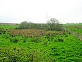
The site of the Loch of Trabboch
East Ayrshire UK relief location map.jpg
Red pog.svg
The Loch of Trabboch or Dalrympleston Loch
Location Trabboch, East Ayrshire, Scotland
Coordinates Coordinates: 55°27′32.0″N4°28′2.7″W / 55.458889°N 4.467417°W / 55.458889; -4.467417
Type Drained freshwater loch
Primary inflows Dalrympleston Burn
Primary outflows Dalrympleston Burn
Basin  countriesScotland
Max. lengthc. 680 ft (210 m)
Max. widthc. 350 ft (110 m)
Average depthShallow
Islands One
Settlements Drongan

The Loch of Trabboch or Dalrympleston Loch (NS440211) was situated in a low-lying area below the old Castle of Trabboch, once held by the Boyd family in the Parish of Stair, East Ayrshire, Scotland.

Contents

History

The loch is recorded as the "Loch of Trabboch" in 1654, pronounced "Traaboch". [1] A small "comma-shaped" island of 18 acre (500 square metres) and around 120 feet (40 metres) long is shown on the first OS maps at co-ordinates 55.458984° N and 4.466443° W.

The Drumdow colliery near the village of Trabboch was abandoned and flooded by 1905 and has become known as Trabboch Loch, [2] the name Dalrympleston Loch or marsh being applied to the old Loch of Trabboch site.

Usage

The loch was a site where swans, moor hens, [3] and other waterfowl nested and as a site within the old Barony of Trabboch it was an area used for hunting and fishing by the laird.

OS maps mark the loch as a curling pond and records show that from 1853 to at least the 1880s it was used for matches between clubs such as those at Tarbolton and Ochiltree. Tarbolton Curling Club used Loch Fail in the 19th century, showing that it was prone to winter flooding at that time. [4]

Cartographic evidence

Blaeu's map of 1654, dating from Timothy Pont's survey of circa 1604, clearly shows and names the loch and indicates only an outflow to the Water of Coyle. [5] Roy's map of 1747 does not show a loch. [6] Thomson map of 1832 does not record a loch. [7]

The 19th century Ordnance Survey maps show the site clearly with an island present, [8] and an inflow from the Dalrympleston Burn, exiting to run down to the Water of Coyle at Gatefoot. An extensive area of wetland is shown extending around the loch waters on early OS maps. The 1897 OS marks the loch as a Curling Pond, but the 1948 map shows a drain running through the loch and no mention of its sue as a curling pond. Many drainage schemes date to the end of World War I when many soldiers returned en masse to civilian life. [9] After 1959 the loch had become a wetland area and no longer had open water.

Scotland relief location map.jpg
Red pog.svg
Loch of Trabboch
Previous location of the Loch of Trabboch, East Ayrshire

Micro-history

Trabboch Castle

The lands of Trabboch are first recorded by name in a rental of 1303–4. King Robert the Bruce gave the L-plan castle to the Boyds of Kilmarnock for services rendered at the Battle of Bannockburn as revealed in an undated charter in the Register of the Great Seal, stating that King Robert I granted the 'lands of Trebach' in Kyle-Regis to Robert Boyd. By 1451 the lands had passed into the hands of William, Earl of Douglas [10] and later to the Boswells of Auchinleck. [11] In the 17th century Chalmers of Gadgirth and Reid of Barskimming held parts of the Barony of Trabboch. [12] Love states that the Arthurs, Lord Ochiltree, and the Campbells of Loudoun also held Trabboch Castle. [13] The associated Mill of Trabboch stood on the Water of Coyle and was not powered by the loch waters.

Campbell sees Trabboch Castle as the only survivor of a defensive chain of castles that once ran across Kyle Regis and included Stair, Auchencloigh, Drongan, and Drumsuie. [14]

Wildlife

A Common Crane, a rare species for Ayrshire was recorded at Dalrympleston marsh in 1987. [15] It is recorded on the bird gazetteer as a site for watching birds. [16]

Views of the Loch of Trabboch site

See also

Related Research Articles

<span class="mw-page-title-main">Drongan</span> Human settlement in Scotland

Drongan is a former mining village in East Ayrshire, some 8 miles (13 km) east of Ayr and west of Cumnock. It had a population of 4686 in 2011.

<span class="mw-page-title-main">Trabboch</span>

Trabboch is a hamlet in East Ayrshire, Scotland. Built as a miners village in the 1880s, it was owned and leased by Wm. Baird & Co., Ltd. and at one time had 94 dwellings. The miners rows stood, until demolition in 1969, on the Stair and Littlemill road, about two miles south of Stair, in that parish. The name is locally pronounced 'Traaboch'.

<span class="mw-page-title-main">Lochlea, South Ayrshire</span> Body of water

Lochlea or Lochlie was situated in a low-lying area between the farms and dwellings of Lochlea and Lochside in the Parish of Tarbolton, South Ayrshire, Scotland. The loch was natural, sitting in a hollow created by glaciation. The loch waters ultimately drained via Fail Loch, the Mill Burn, and the Water of Fail. It is well-documented due to the presence of a crannog that was excavated and documented circa 1878, and its association with the poet Robert Burns, who lived here for several years whilst his father was the tenant. Lochlea lies 2+12 miles northeast of Tarbolton, and just over three miles northwest of Mauchline.

<span class="mw-page-title-main">Helenton Loch</span> Body of water

Helenton Loch was situated in a low lying area between the farms and dwellings of Helentongate, Mains, and Burnbank in the Parish of Symington, South Ayrshire, Scotland. The loch was natural, sitting in a hollow, a kettle hole, created by glaciation. The loch waters ultimately drained via the Pow Burn. Helenton Hill is a prominent landmark to the west of the old loch site. The nearby lands of Rosemount were in 1549 known as 'Goldring' and were the property of the Schaws of Sornbeg.

<span class="mw-page-title-main">Fail Loch</span> Body of water

Fail Loch or Faile Loch was situated in a low-lying area near the old monastery of Fail in the Parish of Tarbolton, South Ayrshire, Scotland. The old Lochlea Loch lies nearby and its waters still feed into Fail Loch via the Mill Burn.

<span class="mw-page-title-main">Hessilhead Loch</span> Body of water

Hessilhead Loch or Hazelhead Loch was situated in a low-lying area near the old Castle of Hessilhead in the Parish of Beith, North Ayrshire, Scotland. The old loch, used in the defence of the castle, was probably infilled when the castle ruins were landscaped in the 19th century.

<span class="mw-page-title-main">Blae Loch (Beith)</span> A lake in Ayrshire, Scotland

The Blae Loch is a small freshwater loch situated in a hollow in a low-lying area beneath Blaelochhead Hill in the Parish of Beith, North Ayrshire, Scotland.

<span class="mw-page-title-main">Galrigs Loch (South Ayrshire)</span> Body of water

The Galrigs Loch was a substantial freshwater loch situated in low lying area between Newfield and Dundonald in South Ayrshire, Scotland. It was drained in the early 18th century.

Trabboch Castle is a ruined L-plan tower house in the old Barony of Trabboch, Parish of Stair, East Ayrshire, Scotland.

<span class="mw-page-title-main">Martnaham Loch</span> Body of water

Martnaham Loch is a freshwater loch lying across the border between East and South Ayrshire Council Areas, two kilometres from Coylton, in the parishes of Coylton and Dalrymple, three miles from Ayr. The loch lies along an axis from northeast to southwest. The remains of a castle lie on a possibly artificial islet within the loch. The Campbells of Loudoun once held the lands, followed by the Kennedys of Cassillis.

<span class="mw-page-title-main">Lochend Loch (Coylton)</span> Body of water

Lochend Loch, which once had nearly three acres in surface area is now only a small freshwater loch remnant. It lies in the South Ayrshire Council Area, lying on the hill above Joppa, between Gallowhill and Lochend Farm.

<span class="mw-page-title-main">Kerse Loch</span> Body of water

Kerse Loch, also recorded as Carse Loch (1841) is a small freshwater loch in the East Ayrshire Council Area, lying in a glacial Kettle Hole, Parish of Dalrymple, Scotland.

<span class="mw-page-title-main">Auchencloigh Castle</span> Ruined fortification in the Parish of Ochiltree, East Ayrshire, Scotland

Auchencloigh Castle or Auchincloigh Castle is a ruined fortification near the Burnton Burn, lying within the feudal lands of the Craufurd Clan, situated in the Parish of Ochiltree, East Ayrshire, Scotland.

<span class="mw-page-title-main">Belston Loch</span> A lake in east Ayrshire, Scotland

Belston Loch, also recorded as Dromsmodda Loch is a small freshwater loch in the East Ayrshire Council Area, near Sinclairston, 2 miles south-east of Drongan, lying in a glacial Kettle Hole. Parish of Ochiltree, Scotland.

Plaid Loch was a freshwater loch in East Ayrshire, now a remnant due to drainage, near Sinclairston and 2 miles (3 km) south-east of Drongan, lying in a glacial kettle hole,.

South Palmerston Loch or Flush, previously known as Loch of the Hill, lying to the east of the 500 ft Back hill Mount. It was one of several small lochs within the Parish of Ochiltree. The loch, lying in a glacial kettle hole, drained into the Lugar Water via the Burnock Water.

<span class="mw-page-title-main">Loch Shield</span> Body of water

Loch Shield, originally Loch of Scheel was a freshwater loch in the East Ayrshire Council Area, now drained, near Drongan, lying in a glacial Kettle Hole, Parish of Ochiltree, Scotland.

<span class="mw-page-title-main">Whitehill Loch</span> Body of water

Whitehill Loch, previously known as Hillhouse Loch was a freshwater loch in the East Ayrshire Council Area, now drained, near Galston, in the Parish of Riccarton, lying in a glacial Kettle Hole.

<span class="mw-page-title-main">Craigie, South Ayrshire</span> Human settlement in Scotland

Craigie is a small village and parish of 6,579 acres in the old district of Kyle, now South Ayrshire, four miles south of Kilmarnock, Scotland. This is mainly a farming district, lacking in woodland, with a low population density, and only one village. In the 19th century, high quality lime was quarried here with at least three sites in use in 1832.

References

Notes
  1. Blaeu's Map Retrieved : 2011-04-17
  2. Ayrshire Birding Archived 2011-09-04 at the Wayback Machine Retrieved : 2011-04-17
  3. Trabboch memories Retrieved : 2011-04-17
  4. Curling Pond Sites [ permanent dead link ] Retrieved : 2011-04-17
  5. Blaeu's Map Retrieved : 2011-04-17
  6. Roy's Map Retrieved : 2011-04-17
  7. Thomson's Map Retrieved : 2011-04-17
  8. NLS Maps Archived 2011-04-11 at the Wayback Machine Retrieved : 2011-04-17
  9. MacIntosh, Pages 37 & 39
  10. RCAHMS Retrieved : 2011-04-17
  11. Coventry, Page 54
  12. Paterson, Page 634
  13. Love, Page 202
  14. Campbell, Page 252
  15. Bird reports Retrieved : 2011-04-17
  16. Gazetteer Retrieved : 2011-04-17
Sources
  1. Adamson, Archibald R. (1879). Rambles through the Land of Burns. Kilmarnock : Dunlop & Drennan.
  2. Barber, Derek (2000). Steps through Stair. Stair Parish Church.
  3. Campbell, Thorbjørn (2003). Ayrshire. A Historical Guide. Edinburgh : Birlinn. ISBN   1-84158-267-0
  4. Coventry, Martin (2010). Castles of the Clans. Musselburgh : Goblinshead. ISBN   1-899874-36-4
  5. Love, Dane (2003). Ayrshire : Discovering a County. Ayr : Fort Publishing. ISBN   0-9544461-1-9.
  6. MacIntosh, Donald (2006). Travels in Galloway. Glasgow : Neil Wilson. ISBN   1-897784-92-9.
  7. Paterson, James (1863–66). History of the Counties of Ayr and Wigton. V. 2 - Part 2 - Kyle. Edinburgh: J. Stillie.