Trabboch Castle

Last updated

Trabboch Castle
Stair, east Ayrshire, Scotland
East Ayrshire UK location map.svg
Red pog.svg
Trabboch Castle
Coordinates 55°28′06″N4°26′27″W / 55.4684°N 4.4408°W / 55.4684; -4.4408
Grid reference grid reference NS 458 221
Site information
OwnerTrabboch Mains Farm
Controlled by Boyd clan
Open to
the public
No
ConditionRuined
Site history
Built14th century
MaterialsStone

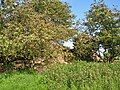
Trabboch Castle (NS 458 221) is a ruined L-plan tower house in the old Barony of Trabboch, Parish of Stair, East Ayrshire, Scotland.

Contents

History

The site of the old Trabboch Mill The remains of Trabboch mill - geograph.org.uk - 728888.jpg
The site of the old Trabboch Mill

The Barony and lairds

The lands of Trabboch (pronounced 'Traaboch') are first recorded by name in a rental of 1303–4. King Robert the Bruce gave the 'L-plan' castle to the Boyds of Kilmarnock for services rendered at the Battle of Bannockburn in 1314, as revealed in an undated charter in the Register of the Great Seal, stating that King Robert I granted the 'lands of Trebach' in Kyle-Regis to Robert Boyd. Following the fall from favour of the Boyds in 1469 Paterson records that the fortalice of Trabach was forfeited to the crown, reportedly for the use of the eldest sons of the Kings of Scotland. [1] The RCAHMS state By 1451 the lands had passed into the hands of William, Earl of Douglas [2] and later to the Boswells of Auchinleck. [3] In the 17th century Chalmers of Gadgirth and Reid of Barskimming held parts of the Barony of Trabboch. [4] Love states that the Arthurs, Lord Ochiltree, and the Campbells of Loudoun also held Trabboch Castle. [5]

As the caput of the Barony of Trabboch a moot hill would have existed and although no remains survive the nearby farm of Lawhill is suggestive of the location. [6] The associated Mill of Trabboch stood on the Water of Coyle and was not powered by the loch waters.

Campbell sees Trabboch Castle as the only survivor of a defensive chain of castles that once ran across Kyle Regis and included Stair, Auchencloigh, Drongan, and Drumsuie. [7]

The remnants and the castle

The remains of Trabboch Castle in 1954 consisted of an L-shaped portion of walling, with no windows or doors apparent, possibly sitting on a motte. [7] The walls are 2.5m thick, with a height around 3.0m, constructed of massive rubble masonry, 9.0m long on the north-western section and 12.5m long on the south-western section. No window or door openings are visible. A broad natural ditch is visible on the western side and the shallow curvilinear ditch on the south side may have been part of the castle defences. [8] Some finds were held by the proprietor of Trabboch Farm. [6] Much of the castle stone was used to build the nearby Trabboch Mains Farm. The castle ruins are now protected as a scheduled monument. [9]

A grave was found nearby (NS 458 221), placed beneath a cairn and cut out of the solid red sandstone, covered by a flagstone and containing some beads and blackish dust. [6]

James Boswell of Auchinleck is recorded to have said that "I wish that my father would buy Trabboch mains, a beautiful farm now offered for sale by Sir John Whitefoord, as it was the very manor-place of the barony of Trabboch, and still has the vestigia of the old house still to be seen." [10]

Cartographic evidence

Gordon's map of 1636–52 shows Trabboch castle. [11] Roy's map of 1747 marks both Trabog (Sic) and Lawhill [12] Molls map of 1745 marks the castle. [13] John Thomson's 1828 map marks Traboch Castle (Sic) clearly. [14]

Scotland relief location map.jpg
Red pog.svg
Trabboch Castle
Location of Trabboch, East Ayrshire

Loch of Trabboch

The ancient Loch of Trabboch was a site where swans, moor hens, [15] and other waterfowl nested and as a site within the old Barony of Trabboch it was an area used for hunting and fishing by the laird. Trabboch Loch is a 19th-century site formed from the flooding of Drumdow pit.

Related Research Articles

<span class="mw-page-title-main">Kerelaw Castle</span>

Kerelaw Castle is a castle ruin. It is situated on the coast of North Ayrshire, Scotland in the town of Stevenston.

<span class="mw-page-title-main">Trabboch</span>

Trabboch is a hamlet in East Ayrshire, Scotland. Built as a miners village in the 1880s, it was owned and leased by Wm. Baird & Co., Ltd. and at one time had 94 dwellings. The miners rows stood, until demolition in 1969, on the Stair and Littlemill road, about two miles south of Stair, in that parish. The name is locally pronounced 'Traaboch'.

Riccarton is a village and parish in East Ayrshire, Scotland. It lies across the River Irvine from Kilmarnock, this river forming the boundary between Riccarton and Kilmarnock parishes, and also between the historical districts of Kyle and Cunningham. The name is a corruption of 'Richard's town', traditionally said to refer to Richard Wallace, the uncle of Sir William Wallace. The parish also contains the village of Hurlford.

<span class="mw-page-title-main">Craigie Castle</span>

Craigie Castle, in the old Barony of Craigie, is a ruined fortification situated about 4 miles (6.4 km) southeast of Kilmarnock and 1 mile (1.6 km) southeast of Craigie village, in the Civil Parish of Craigie, South Ayrshire, Scotland. The castle is recognised as one of the earliest buildings in the county. It lies about 1.25 miles (2 km) west-south-west of Craigie church. Craigie Castle is protected as a scheduled monument.

<span class="mw-page-title-main">Castle and Barony of Robertland</span>

The Castle and Barony of Robertland is located near Stewarton, off the B769 road, in the old district of Cunninghame, Parish of Stewarton, and now part of East Ayrshire, Scotland.

<span class="mw-page-title-main">Fail Monastery</span> Former monastery in Ayrshire, Scotland

Fail Monastery, occasionally known as Failford Abbey, had a dedication to 'Saint Mary', and was located at Fail on the bank of the Water of Fail, Parish of Tarbolton near the village of Tarbolton, South Ayrshire. Most of the remaining monastery ruins were removed in 1952. The official and rarely used title was House of the Holy Trinity of Failford or the Ministry of Failford.

<span class="mw-page-title-main">Terringzean Castle, East Ayrshire</span>

Terringzean Castle, also Taringzean, pronounced 'Tringan', is a Category B listed castle ruin lying above the River Lugar and the Terringzean Holm in the policies of Dumfries House, Parish of Cumnock, Scotland. The name Craufordstone or Craufurdstoun, has also been used, echoing that it and these lands originally belonged to the Crawfords, as did Lefnoreis Castle or Lochnorris Castle which once stood near the site of the Dumfries House stables.

<span class="mw-page-title-main">Barnweill Church</span> Ruined pre-reformation kirk in South Ayrshire, Scotland

Barnweill Church or Barnweil Church is a ruined pre-reformation kirk situated on rising ground on the slopes of Barnweill Hill, Parish of Craigie, South Ayrshire, Scotland; about 3 km from Tarbolton. The church was known locally as the "Kirk in the Wood". It lies about 170m North North-East of Kirkhill Farm. Barnweill was central to the Protestant Reformation in Ayrshire through its association with John Knox. The spelling 'Barnweill' is used throughout for consistency.

<span class="mw-page-title-main">Hill of Beith Castle</span>

The old Barony and castle, fortalice, or tower house of Hill of Beith lay in the feudal Regality of Kilwinning, within the Baillerie of Cunninghame, and the Sherrifdom of Ayr, now the Parish of Beith, North Ayrshire, Scotland.

<span class="mw-page-title-main">Helenton Loch</span> Drained freshwater loch in South Ayrshire, Scotland

Helenton Loch was situated in a low lying area between the farms and dwellings of Helentongate, Mains, and Burnbank in the Parish of Symington, South Ayrshire, Scotland. The loch was natural, sitting in a hollow, a kettle hole, created by glaciation. The loch waters ultimately drained via the Pow Burn. Helenton Hill is a prominent landmark to the west of the old loch site. The nearby lands of Rosemount were in 1549 known as 'Goldring' and were the property of the Schaws of Sornbeg.

<span class="mw-page-title-main">Shaw Monument</span> Church in South Ayrshire, Scotland

The Shaw Monument is an 18th-century structure that has been interpreted as a folly and stands about 1 mile East of Prestwick, overlooking Prestwick Airport in South Ayrshire, Scotland.

<span class="mw-page-title-main">The Lands of Pitcon</span>

The Lands of Pitcon, previously Potconnel now form a small estate of around 100 acres in the Parish of Dalry, North Ayrshire in the old Barony of Dalry. The present category B listed Georgian mansion house dating from 1787, replaces an older castellated dwelling. Pitcon lies on the outskirts of Drakemyres, now a suburb of Dalry, close to the confluence of the Rye Water, River Garnock, and the Mains Burn, standing on a low knoll. Such a marshy area would have provided a degree of protection to the old castle.

<span class="mw-page-title-main">Loch of Trabboch</span> Drained freshwater loch in East Ayrshire, Scotland

The Loch of Trabboch or Dalrympleston Loch (NS440211) was situated in a low-lying area below the old Castle of Trabboch, once held by the Boyd family in the Parish of Stair, East Ayrshire, Scotland.

<span class="mw-page-title-main">Loch Fergus</span> Freshwater loch in South Ayrshire, Scotland

Loch Fergus is a freshwater post-glacial "Kettle Hole" sometimes recorded as Fergus Loch. It is quite visible and is situated in a low-lying area close to the B742 road between the farms and dwellings of Trees, Lochfergus and Bowmanston in the Parish of Ayr, South Ayrshire, Scotland. The loch lies to the north of Martnaham Loch, four miles east-southeast of Ayr. It drains to the southwest into the Snipe Loch.

<span class="mw-page-title-main">Auchenbathie Tower</span>

Auchenbathie, Auchinbathie Tower or rarely Barcraigs Tower is a ruined fortification, a tower house, once held by the Wallace Clan of Elderslie, situated in Renfrewshire, Parish of Lochwinnoch, Scotland. The spelling used varies greatly and "Auchenbathie" will be used here as the standard spelling. The pronunciation locally is "Auchenbothy", the same as a Victorian mansion in Kilmacolm; no connection is known.

<span class="mw-page-title-main">Auchencloigh Castle</span> Ruined fortification in the Parish of Ochiltree, East Ayrshire, Scotland

Auchencloigh Castle or Auchincloigh Castle is a ruined fortification near the Burnton Burn, lying within the feudal lands of the Craufurd Clan, situated in the Parish of Ochiltree, East Ayrshire, Scotland.

<span class="mw-page-title-main">Barony of Kersland</span>

The remains of the old castle of Kersland lie about 1.5 miles to the north-east of the town of Dalry in North Ayrshire, Scotland, in the old Barony of Kersland. The River Garnock lies nearby.

<span class="mw-page-title-main">Craigie, South Ayrshire</span> Human settlement in Scotland

Craigie is a small village and parish of 6,579 acres in the old district of Kyle, now South Ayrshire, four miles south of Kilmarnock, Scotland. This is mainly a farming district, lacking in woodland, with a low population density, and only one village. In the 19th century, high quality lime was quarried here with at least three sites in use in 1832.

<span class="mw-page-title-main">Kyle Castle</span>

The ruins of the large courtyard style Kyle Castle, once also known as Cavil Castle or occasionally Dalblair Castle lie close to the hamlet of Dalblair in Auchinleck parish near Muirkirk in the East Ayrshire council area, Scotland. The castle stands at the confluence of the Guelt Water and the Glenmuir Water on a peninsula carved out by these rivers. Its name suggests that it was once of some significance.

<span class="mw-page-title-main">Castle and Barony of Gadgirth</span>

The Castle and Barony of Gadgirth was held by the Chalmer family, originally De Camera, with successive castles and a mansion house overlooking the River Ayr at the border of the Parish of Coylton, the old district of Kyle, now part of South Ayrshire, Scotland.

References

Notes
  1. Paterson, Page 17
  2. RCAHMS Retrieved : 2011-04-17
  3. Coventry, Page 54
  4. Paterson, Page 634
  5. Love, Page 202
  6. 1 2 3 Smith, page 143
  7. 1 2 Campbell, Page 252
  8. RCAHMS Retrieved : 2011-04-26
  9. ( Historic Environment Scotland & SM5281 )
  10. Davis, Page 392
  11. Gordon's Map Retrieved : 2011-04-26.
  12. Roy's Map Retrieved : 2011-03-19
  13. Moll Retrieved : 2011-04-26
  14. Thomson's Map Retrieved : 2011-04-26
  15. Trabboch memories Archived 2012-06-25 at the Wayback Machine Retrieved : 2011-04-17
Stair Parish church Stair Church, Ayrshire.JPG
Stair Parish church
Sources
  1. Adamson, Archibald R. (1879). Rambles through the Land of Burns. Kilmarnock : Dunlop & Drennan.
  2. Barber, Derek (2000). Steps through Stair. Stair Parish Church.
  3. Campbell, Thorbjørn (2003). Ayrshire. A Historical Guide. Edinburgh : Birlinn. ISBN   1-84158-267-0
  4. Coventry, Martin (2010). Castles of the Clans. Musselburgh : Goblinshead. ISBN   1-899874-36-4
  5. Davis, Michael C. (1991). The Castles and Mansions of Ayrshire. Ardrishaig : Spindrift Press
  6. Historic Environment Scotland. "Trabboch Castle (SM5281)" . Retrieved 25 February 2019.
  7. Love, Dane (2003). Ayrshire : Discovering a County. Ayr : Fort Publishing. ISBN   0-9544461-1-9.
  8. Paterson, James (1863–66). History of the Counties of Ayr and Wigton. V. 2 – Part 2 – Kyle. Edinburgh: J. Stillie.
  9. Smith, John (1895). Prehistoric Man in Ayrshire. London : Elliot Stock.