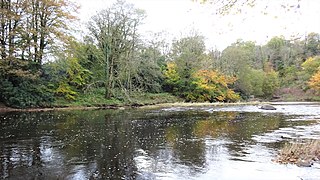
The Castle and Barony of Gadgirth[1] was held by the Chalmer family,[2] originally De Camera, with successive castles and a mansion house overlooking the River Ayr at the border of the Parish of Coylton, the old district of Kyle, now part of South Ayrshire, Scotland.[2][3]
Reginaldus de Camera, later Chalmer, is recorded to have held the Barony of Gadgirth as a hereditary possession,[4] during the reign of William the Lion (1165–1214).[1] The family continued in residence until circa 1761 and in 1800 Colonel Joseph Burnett, retired from the East India Company, purchased part of the old barony, including Gadgirth and the Old Ha' Castles.
The name 'Chalmer' derives from the post of Lord or Great Chamberlain of Scotland, Camerarius Regii a position held by Herbert de Camera from 1124 to 1153,[5] a member of the family who were of Saxon or Norman descent.[4] In 1357 the 'Farthing Land of Gadgard (sic) is recorded its tithe and 50s as the assessed rent.[4] The lands of Gaitgirth (sic) and Culreath were joined to form one Barony in 1468.[6]
In 1424 John Chalmer of Gadgirth fought for King Charles VII of France against the English at the Battle of Vernuie and was awarded the right to use the Fleur de Lis in recognition of his gallantry. He is thought to have died at the Battle of Herrings in 1429.[6]
Gravestone of John or William Chalmer at Coylton, dated 1693
Sir John Chalmer's wife Elizabeth was charged before the King's Council in 1494 as an adherent to the Lollard's, a heretical doctrine promulgated by John Wycliffe. The charge was dismissed by King James IV.[7]
James Chalmer of Gadgirth was a great supporter of the Scottish Reformation and was regarded by Archbishop Spottiswood and John Knox as one of the boldest of the leaders of the movement. In 1558, Mary of Guise, the Queen Regent, a supporter of the Catholic Church, was meeting with the Catholic bishops, when a delegation of reformers entered the privy chamber and James Chalmer addressed her, saying (in updated English) "Madam you know of the malice of the jail birds and that bastard that stands beside you (the bishop of St. Andrews). We swear to God we shall make a fight of it. They oppress us and our tenants, for feeding their idle bellies. They trouble our preachers, and intend to murder them and us. Shall we not put up with this any longer.” The reformers then put on their helmets as if they were about to use force. Mary quickly compromised with the reformers.[8]
Annabelle Cunningham was the wife of James Chalmer and when she died in 1569 her will stated that "I do commend my spirit to Jesus Christ my onlie saviour and redeemer, in quhome and by quhome I luke for eternaljoy and felicite."[9]
The laird of Gadgirth is recorded as having great misgivings relating to the economic control that the clergy had upon him and his tenants.[10]
In 1696 Captain John Chalmers inherited the barony as a minor from his father John, however almost all of the lands had passed into others hands as a result of debts incurred as a result of the Chalmer family supporting King Charles I. John managed to restore some of the barony lands to Chalmer ownership however he died circa 1750 without a male heir and the property passed to his sisters Mary, Anna and Elizabeth.[11]
Mary left her portion to her husband, John Steel of Gadgirth and his daughter by a second marriage, married Lieut-Colonel Joseph Burnett of the Bengal Artillery who purchased his sister-in-laws portion of the barony.[12] James Muir, Elizabeth's eldest son, changed his name to Chalmer and inherited his aunt, Anna Chalmer's, portion of the barony.[12]
Grave of Francis Claude Burnett at Coylton old parish church
Joseph Burnett died in 1833 and his son John Joseph Burnett inherited however he never married and the barony passed to his brother Lieut-Colonel Francis Claude Burnett of the Bengal Artillery who died on August 19, 1897.[12] He was buried with his wife Mary in the family mausoleum at the Coylton Kirk cemetery.
The Chalmer's were connected through marriage with many families in Ayrshire and elsewhere, such as the Campbells of Loudoun, Hamiltons of Cadzow, Cuninghames of Caprington, Wallace of Ellerslie, Craufurd of Craufurdland, Fergusson of Craigdarroch,[13] Farquhar of Gilmilnscroft, etc.[12]
The Chalmer of Gadgirth coat of arms is Argent, a demi-lion rampant, Sable, issuing out of a Fess, and in base, a Fleur-de-Lis: all within a border, Gules. Crest - a falcon, belled, proper. Motto - Non Praeda sed Victoria (Not spoiled by victory).
The Burnett of Gadgirth coat of arms is Argent. Crest - A Holly Branch, green, with red berries. Shield - Three holly leaves on a white ground in the upper division; on the lower, a Hunting Horn. Motto - Nec Fluctu, nec Flatu (Neither by Wave nor Wind)..[14]
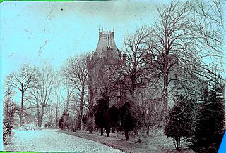
Gadgirth Castle
The castle, probably a typical 14th century[3] tower castle,[1] replaced the earlier Gadgirth Old Ha' that stood around 500 metres or a quarter of a mile downstream on the same southern side of the River Ayr, abandoned when the new castle was built. Gadgirth Castle was itself demolished in 1808[15] when a new mansion house was built on its footprint by Colonel Joseph Burnett who had retired from his post with the East India Company. Joseph had intended to retain the castle however it proved to be unsuitable for modification with walls six feet thick.[15][2][16] Extensive woodlands and a pale or fence are shown on Timothy Pont's map of the early 17th century indicating a deer park.[17] A dwelling is shown on the 1775 Armstrong map that appears to indicate a house rather than a castle with planted woodlands and open parkland, with a road running to it via Enterkine and with a bridge across the River Ayr as confirmed by the dwelling named Bridgend.[18] A print of 1892 by the artist Robert Bryden shows a castle that has been given some Georgian features such as regular windows and ornamental bartizan towers. It not known what source was used to create the print and therefore the accuracy of the image is unknown.[19]
As stated, the first castle, Gadgirth Old Ha', also lay on the southern side of the River Ayr near the B742 road that crosses the River Ayr at Gadgirth Bridge and runs up to Annbank.[3] The castle jutted into the river on a rocky promontory with an islet located within the river at this point. The historian John Smith in the 1890s visited the site and recorded that even at that date only a short stretch of wall could be traced.[2]
Gadgirth House
Gadgirth Holm Cottages
Built in 1808 on a prominent position overlooking the River Ayr and Gadgirth Holm it was purchased in 1949 by the council became a children's home.[16] It was demolished in 1968.[20] It had been built on the site of Gadgirth Castle.[3] As stated, the 1775 William Armstrong map appears to indicate a house rather than a castle with a road running to it via Enterkine and with a bridge across the River Ayr as confirmed by the name Bridgend.[18][19] In 1828 the mansion house is clearly shown with a network of roads.
Gadgirth House is shown on photographs and prints as a mansion with similarities to Logan House near Cumnock and probably designed by the same architect.[19] It had "an advanced, eliptical, bowed projection on the centre of both main fronts, the projection on the garden front being further advanced than that on the entrance front".[19] In 1903 alterations were carried out that were designed by the architects Honeyman, Keppie and Mackintosh.[19]
Gadgirth Holm Cottages - Dated 1906 on their monogram, a terrace of eight estate cottages in Arts and Crafts style were built just downstream from Gadgirth Bridge.[20][16] The 1906 cottages replaced an earlier set cottages, a miner's row, on the site as shown on OS maps with two coal pits nearby.
Gadgirth Mains This was the home farm and was built circa 1807. A courtyard design, it has a central arched entrance with a small dovecot above. An advert in 1807 refers to a set of farm offices that were to be built in the summer of 1808.[20] On the 1750s map by William Roy a 'Gath Gard Mains' is already shown.[21] A gasometer was located here to hold the coal gas made on site.
Estate features - A walled garden survives which once had several greenhouses and other buildings associated with it. The OS maps also record a monument or obelisk built in the centre of one of two old 18th century wooded roundel features[21] on top of the hill that lies above Gadgirth Mains.[22] The monument bore no inscription[16] and given the fashion of early 19th century memorials to Horatio Nelson, the Battle of Trafalgar or the Battle of Waterloo it may relate to one of these or a family linked origin.
John Thomson's map of 1828 indicates an ornamental lake in front of Gadgirth House in the Byre Burn Glen, however this is no longer shown in 1908. In 1908 a sundial was shown on the OS in front of the mansion house. Gadgirth Cottage and Bankfoot Cottages were once situated on the lane to Knockshoggle Holm. The Kennels Cottage also survives as do the gates.[19]
Gadgirth Viaduct
Enterkine or Gadgirth Viaduct
Also known as the Enterkine Viaduct this wrought iron bridge on stone pillars originally carried the old G&SWR line from Ayr to Cronberry over the River Ayr, latterly it was used to carry coal trains to the Killoch washery. It was still in service in 2009.[20]
Etymology
The name 'Gadgirth' is also variously written as 'Gadgard',[4] 'Gaitgirth',[4] 'Galdgirth'.[4] and may either refer to an archaic Scots unit of land measurement[3] or even the personal name 'Galdus', recorded as an ancient King of Scots commemorated at Wigton.[23][24] 'Garth' or 'Girth' refers to an enclosure. The name is given as 'Gaidyant' on Timothy Pont's map of the early 17th century.[17] The same spelling is given in 1745.[25] 'Gath Gard' is the spelling shown on William Roy's map of the 1750s.[21] Armstrongs map of 1775 uses the spelling 'Gadgirth'.[18]
Industry
Remains of a Gadgirth Coal Pit
The ancient Privick Mills are located on the opposite bank of the River Ayr from the castles and mansion house sites with at one time extensive stone weir and lade carrying the water to the mill's wheel. It is marked as 'Preuik Mil' on Timothy Pont's early 17th century map and may have been associated with Privick House, later known as Annbank House, renamed after Lady Ann Montgomery but demolished in the 1970s.[17][26] A charter of 1359 does refer to a mill and grannary belonging to the lands of Gadgirth.[4]
At least two coal pits are recorded,[27] one lying above Gadgirth Mains with some ruins remaining and the other with an engine house in the Byre Burn Glen.[22] In 1875 one miner was killed and a second mortally injured. William Kerr, aged around 50, was working in the No. 1 Gadgirth Pit, Annbank Colliery and had been excavating a wedge-hole when a one ton block of coal fell on him. Taken out of the adit and carried home he died shortly afterwards, leaving a widow and ten offspring. Only two hours later a similar accident happened to a David M'Crorie, a younger man. His left arm was amputated, but his other injuries were so serious that he is not thought to have pulled through.[28]
Chalmerhouses, Irvine
The Chalmer family in 1558 held 52 acres of lands at Thornlibank also known as Chalmerhouses located at the east end of the burgh of Irvine. The burial place of the Chalmers of Chalmerhouses was at the wall of the old churchyard, on the left-hand side when walking towards the church from the Kirkgate.[29]
Related Research Articles
Annbank is a village in South Ayrshire, Scotland. It is around five miles east of Ayr. Originally a mining settlement, it once had a rail link to Ayr via the Auchincruive Waggonway.
Kerelaw Castle is a castle ruin. It is situated on the coast of North Ayrshire, Scotland in the town of Stevenston.
The Barony of Ladyland was in the old feudal Baillerie of Cunninghame, near Kilbirnie in what is now North Ayrshire, Scotland.
Dalmore was a country house and small estate in the Parish of Stair, East Ayrshire, on the River Ayr, East Ayrshire, Scotland
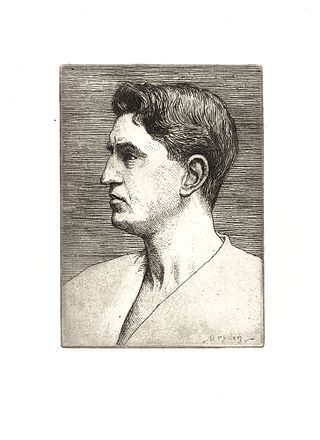
Robert Bryden was a Scots artist and sculptor.
The Lands of Pitcon, previously Potconnel now form a small estate of around 100 acres in the Parish of Dalry, North Ayrshire in the old Barony of Dalry. The present category B listed Georgian mansion house dating from 1787, replaces an older castellated dwelling. Pitcon lies on the outskirts of Drakemyres, now a suburb of Dalry, close to the confluence of the Rye Water, River Garnock, and the Mains Burn, standing on a low knoll. Such a marshy area would have provided a degree of protection to the old castle.
The Loch of Trabboch or Dalrympleston Loch (NS440211) was situated in a low-lying area below the old Castle of Trabboch, once held by the Boyd family in the Parish of Stair, East Ayrshire, Scotland.
Trabboch Castle is a ruined L-plan tower house in the old Barony of Trabboch, Parish of Stair, East Ayrshire, Scotland.
Polkelly Castle, also Pokelly, was an ancient castle located near Fenwick, at NS 4568 4524, in the medieval free Barony of Polkelly, lying north of Kilmarnock, Parish of Fenwick, East Ayrshire, Scotland. The castle is recorded as Powkelly (c1747), Pockelly (c1775), Pow-Kaillie, Ponekell, Polnekel, Pollockelly, Pollockellie, Pokellie, Pothelly, Pathelly Ha' and Polkelly. The name is given circa 1564 as Powkellie when it was held by the Cunninghams of Cunninghamhead.
Baron of Lochmartnaham (extinct) was a title of nobility in the Baronage of Scotland for the holder of the barony with its caput baronium at Martnaham Castle on Martnaham Loch in Ayrshire. The Crauford family held the barony prior to the 14th century, when the Campbells of Loudoun held the lands, followed by the Kennedys of Cassillis.
The Lands of Borland or Boreland formed a castle and land holdings within the old Barony of Cumnock, East Ayrshire, Parish of Old Cumnock, Scotland. Lying two miles south of Cumnock the property was mainly held by a cadet branch of the Hamilton family from around 1400 before passing by marriage to the Montgomeries and others. For consistency the spelling 'Borland' will be used throughout.
Earlston is a hamlet in Riccarton, East Ayrshire, Scotland. The habitation dates from at least the early 18th century and is near Caprington Castle and Todrigs Mill. It was for many years the site of a large sawmill and a mine pumping engine, and had sidings of the Glasgow and South-Western Railway's Fairlie Branch.
What now survives of the old Caprington Loch (NS402352) is situated near Earlston, Riccarton, East Ayrshire, Scotland. The loch was a natural feature, sitting in a hollow on the old Caprington Castle estate. The loch waters drain via the Todrigs Burn that flows into the River Irvine to the east of Gatehead village. It was partly drained, probably sometime after the 1820s, as were so many other lochs, as part of 18th and 19th centuries extensive agricultural improvements and the only area of open water that remains does so as it was once used as a curling pond for the Caprington Castle Estate owners and their employees or tenants.
The site of the old Lefnoreis Castle or Ward of Lochnorris lies about 100 yards north-west of the old stable block of Dumfries House in East Ayrshire, Parish of Old Cumnock, Scotland. The old castle stood on a natural rise overlooking the Lugar Water, built and held for many years by the Craufurd family. For consistency the spelling Craufurd will be used throughout and Lefnoreis for the castle.
Minishant is a village bordering the A77 in the old county of Carrick, South Ayrshire, Scotland. It is located in Maybole Parish, 3+1⁄2 miles from Maybole and standing close to the River Doon. The village was originally named Culroy after the Culroy Burn that runs through it.
The ruins of the large courtyard style Kyle Castle, once also known as Cavil Castle or occasionally Dalblair Castle lie close to the hamlet of Dalblair in Auchinleck parish near Muirkirk in the East Ayrshire council area, Scotland. The castle stands at the confluence of the Guelt Water and the Glenmuir Water on a peninsula carved out by these rivers. Its name suggests that it was once of some significance.
The castle known as Gadgirth Old Ha' or Gadgirth Old Hall, was the first castle at Gadgirth, held by the Chalmer family, standing on a whinstone promontory overlooking the River Ayr in the Parish of Coylton, the old district of Kyle, now part of South Ayrshire, Scotland.
The Lands of Templehouse formed a small estate lying between Aiket Castle and the town of Dunlop, East Ayrshire, Parish of Dunlop, Scotland. The laird's house at Templeland of Dunlop Hill, to give it its formal name, stood near to the ancient road leading from Dunlop to Kirkwood and on to Kennox. The lands were held by the Knights Templar until a date prior to 1570 when the Gemmells of Templehouse were granted the property and remained there until 1962, a period of around 500 years. The spelling 'Gemmell' is used for consistency except where otherwise denoted.
The Lands of Dallars or Auchenskeith (NS463337) form a small estate in East Ayrshire, Hurlford, Kilmarnock, Parish of Riccarton, Scotland. The present mansion house is mainly late 18th-century, located within a bend of the Cessnock Water on the site of older building/s. "Dullers or Dillers" was changed to "Auchenskeith" or "Auchinskeigh" (sic) as well as other variants and then the name reverted nearer to the original form as "Dollars" and then finally "Dallars". Dallars lies 3.25 km south of Hurlford.
The Castle and Lands of Auchruglen (NS5365436797) was a peel tower in the old district of Kyle held at different times by the Nesbitt and Campbell Clans and located near Newmilns, Parish of Galston, East Ayrshire, Scotland.
Campbell, Thorbjorn (2003). Ayrshire. A Historical Guide. Edinburgh: Birlinn. ISBN1-84158-267-0.
Davis, Michael (1991). The Castles and Mansions of Ayrshire. Pub. privately.
Love, Dane (2003). Ayrshire: Discovering a County. Fort Publishing Ltd. ISBN0-9544461-1-9.
McJannet, Arnold F. (1938). Royal Burgh of Irvine. Glasgow: Civic Press.
Paterson, James (1863). History of the Counties of Ayr and Wigton. V.1. Kyle. Edinburgh: James Stillie.
RCAHMS. (1985b) The Royal Commission on the Ancient and Historical Monuments of Scotland. The archaeological sites and monuments of North Kyle, Kyle and Carrick District, Strathclyde Region, The archaeological sites and monuments of Scotland series no 25. Edinburgh. Page(s): 24, No.114 RCAHMS Shelf Number: A.1.2.ARC/25.
Close, Robert (1992). Ayrshire and Arran: An Illustrated Architectural Guide. Pub. Roy Inc Arch Scot. ISBN1873190-06-9.
Smith, J. (1895) Prehistoric man in Ayrshire. London: Elliot Stock.
This page is based on this Wikipedia article Text is available under the CC BY-SA 4.0 license; additional terms may apply. Images, videos and audio are available under their respective licenses.