Culross (/ˈkurəs/) is a village and former royal burgh, and parish, in Fife, Scotland.

Penrith is a market town and civil parish in the Westmorland and Furness district of Cumbria, England. It is less than 3 miles (5 km) outside the Lake District National Park and about 17 miles (27 km) south of Carlisle. It is between the Rivers Petteril and Eamont and just north of the River Lowther. The town had a population of 15,181 at the 2011 census. It is part of historic Cumberland.

Houston, is a village in the council area of Renfrewshire and the larger historic county of the same name in the west central Lowlands of Scotland.

Carnbee is a village and rural parish in the inland part of the East Neuk of Fife, Scotland.

Aberdalgie is a small village in the Scottish council area of Perth and Kinross. It is 3 miles southwest of Perth, and lies between the B9112 road, to the north, and the River Earn, to the south. Milltown Burn and Cotton Burn streams meet in the village centre, The village contains Aberdalgie Parish Church, the present building of which dates to 1773. The historic Dupplin Castle is 1+1⁄2 miles east of the village.
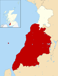
Kilmacolm is a village and civil parish in the Inverclyde council area, and the historic county of Renfrewshire in the west central Lowlands of Scotland. It lies on the northern slope of the Gryffe Valley, 7+1⁄2 miles southeast of Greenock and around 15 miles (24 km) west of the city of Glasgow. The village has a population of around 4,000 and is part of a wider civil parish which covers a large rural hinterland of 15,000 hectares containing within it the smaller settlement of Quarrier's Village, originally established as a 19th-century residential orphans' home.

St Monans, sometimes spelt St Monance, is a village and parish in the East Neuk of Fife and is named after the legendary Saint Monan.
Barr is a village in South Ayrshire, Scotland, approximately 8 miles (13 km) from the town of Girvan. There are various opinions as to the origins of the name. The most likely is the Gaelic bàrr meaning 'a hill-top, a height'. It is believed to have been established in the 17th century by smugglers who needed a safe place close to the secluded bays of the Ayrshire coast while having access to the Raiders Road which runs close by. Barr has not grown much since that time. Currently Barr Village has a population of approximately 110, while the total for the Parish of Barr is in the region of 260.

Sir Robert Stodart Lorimer, KBE was a prolific Scottish architect and furniture designer noted for his sensitive restorations of historic houses and castles, for new work in Scots Baronial and Gothic Revival styles, and for promotion of the Arts and Crafts movement.
Currie is a village and suburb on the outskirts of Edinburgh, Scotland, situated 7 miles south west of the city centre. Formerly within the County of Midlothian, it now falls within the jurisdiction of the City of Edinburgh Council. It is situated between Juniper Green to the northeast and Balerno to the southwest. It gives its name to a civil parish.

Strathblane is a village and parish in the registration county of Stirling, situated in the southwestern part of the Stirling council area, in central Scotland. It lies at the foothills of the Campsie Fells and the Kilpatrick Hills on the Blane Water, 12 miles (19 km) north of Glasgow, 14 miles (23 km) east-southeast of Dumbarton, and 20 miles (32 km) southwest of Stirling. Strathblane is a dormitory village for Greater Glasgow, and has a total resident population of 1,811.
Longforgan is a village and parish in the Carse of Gowrie, in Perth and Kinross, Scotland. It lies 5 miles west of Dundee on the main A90 road.
Whitekirk is a small settlement in East Lothian, Scotland. Together with the nearby settlement of Tyninghame, it gives its name to the parish of Whitekirk and Tyninghame.
Minto is a village and parish in the Scottish Borders area of Scotland in Roxburghshire county. It is located 6 miles north-east of Hawick, north of the River Teviot.

Greystoke is a village and civil parish on the edge of the Lake District National Park in Cumbria, England, about 4 miles (6.4 km) west of Penrith. At the 2001 census the parish had a population of 642, increasing marginally to 654 at the 2011 Census. The village centres on a green surrounded by stone houses and cottages.

Torthorwald is a village and civil parish in Dumfries and Galloway, south-west Scotland. It is located 6 kilometres (3.7 mi) east of Dumfries on the A709 road to Lochmaben. The area was the property of the de Torthorwald family until the end of the 13th century, when the estate passed by marriage to the Kirkpatricks. In 1418, William de Carleil married the Kirkpatrick heiress. He may have been the builder of Torthorwald Castle, which was erected around this time, possibly on top of an earlier a motte. Torthorwald was erected as a burgh of barony in 1473. Torthorwald Castle was occupied until 1715; only two of its walls still stand, to a height of around 18 metres (59 ft).
Heronsford is a village located in South Ayrshire, South-West Scotland.

Skirling is a parish, community council area and village in Peeblesshire in the Scottish Borders situated 2+1⁄2 miles east of Biggar in Lanarkshire. Biggar Water, a tributary the River Tweed forms the southern boundary of the parish with the parish of Broughton, Glenholm and Kilbucho. It is also bounded by that parish on the east, namely the Broughton part of it. On the north it is bounded by the parish Kirkurd in Peeblesshire. Spittal Burn forms most of its western boundary with Lanarkshire.

Lendalfoot is a small village located on Carleton Bay, parish of Colmonell in the old district of Carrick, now South Ayrshire, about six miles south of Girvan, Scotland. This is mainly a farming district, lacking in woodland, with a low population density. The village sits astride the A77 that runs north to Girvan and south to Cairnryan and Stranraer. Carleton Hill rises to 520 feet or 158 metres from the road and is the site near its summit of earth banks, an ancient fort.

The ruins of the five storey high 15th century Carleton Castle lie in a prominent position above the village of Lendalfoot located on Carleton Bay, parish of Colmonell in the old district of Carrick, now South Ayrshire, about 6 miles south of Girvan, Scotland.