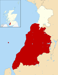
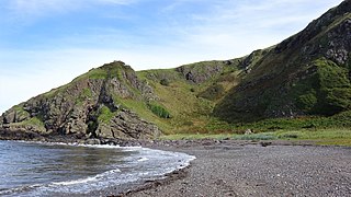
Lendalfoot is a small village located on Carleton Bay, parish of Colmonell in the old district of Carrick, now South Ayrshire, about six miles (ten kilometres) south of Girvan, Scotland.[1] This is mainly a farming district, lacking in woodland, with a low population density. The village sits astride the A77 that runs north to Girvan and south to Cairnryan and Stranraer. Carleton Hill rises to 520 feet or 158 metres from the road and is the site near its summit of earth banks, an ancient fort.[1]
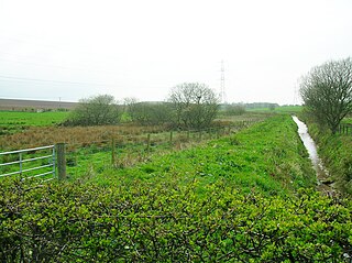
The Lendal Water rises from Loch Lochton and runs around four miles (six kilometres) before reaching the village and the sea at Carleton Bay.[2]
Lendalfoot is the closest Mainland Scotland village to Ailsa Craig.[3]
History
The memorial to Archie Hamilton and his crew
The village once had a post office and also a school that now serves as the community centre. A row of old farm workers cottages stands on the side of the road with back walls facing the sea. Carleton Terrace lies to the south of the village centre and dates from around 1933 when the Hamilton Estates made land available for what were then holiday homes, mostly built from wood at first, later on many were rebuilt in stone.[4] The village has no church of its own however, as stated, it is part of the Colmonell Parish.
The Kittyfrist Well stands on the old coast road from Girvan, once a reliable source of water for travellers. This inland route was replaced by the modern day coastal course made possible by "Kennedy's Pass" forced through the rocks using explosives. The "Forest of Rocks" is a term used for the numerous sea stacks along this section of the coastline. Two of the sea stacks had the appearance of human figures and were called the 'Old and the young Laird'.[5]
Next to the ruins of one of several hay rees on the raised beach area near the Lendal Water stands an old sea stack that is named on the OS map as the 'Deafstone'.[6] Many Cornish miners came to Scotland and in Cornwall this term referred to rock that was deaf or useless.[7]
A memorial stands on the side of the road with its back to the sea, consisting of a gravestone-like carved stone surrounded by a white painted wall. This structure commemorates the wrecking of a ship on this rocky shore and the drowning of Archie Hamilton and his crew from King's Cross on Arran on 11 September 1711.[8]
Charles Berry (1852–1909) was an ornithologist and naturalist with a particular interest in the migratory behaviour of wheatears (Oenanthe oenanthe) who lived in the area and is commemorated on a memorial standing close to the Lendal Water on a low mound.[4]
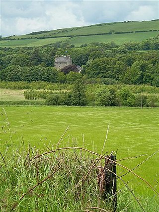
Carleton Castle is a 15th-century five-storey tower and barmakin, once held by the Cathcarts of Killochan that stands in a prominent position overlooking the village close to the Games Loup cliffs. The tower ruins still stand, apart from a collapsed section of wall that has been partly rebuilt at some stage and internal plastering suggests a later use as a dwelling. At the back of the tower pigsties type ruins survive that were still roofed in the 19th century according to OS maps. The barmakin or walled courtyard existed with towers at the angles on the area between the two glens and their burns.[4] It guarded and controlled a mountain pass as well as the road along the raised beach.[9] The tower had two vaults, one over the great hall and the second over the ground floor.[10]
A substantial earth mound, the Carleton Fort or Motte with a circular ditch and palisaded bank built some centuries prior to the stone castle stands across from Little Carleton Farm, damaged by the construction of the lane to the village.[4] Standing close to the castle the motte may nave served as the moot hill where the laird's barony court met. No place name evidence for a gallows hill has been noted.
Sir John Cathcart and the murdered heiresses
Carleton Castle tower
A legend derived from the ballad May or Mary Culzean[11] exists in several versions in different books.[12] The essence of the story is that Sir John Cathcart of Carleton Castle was in the habit of enriching his estate through marrying heiresses. The steep Games Loup cliffs stand close to the castle and one by one his brides met their end by accidentally falling from the path that ran along the edge. Mary Kennedy of Culzean was his ninth heiress bride and one evening whilst walking along the Games Loup her husband informed her that she was to meet her end, but that he would keep her valuable jewel and gold thread enriched clothes. Mary told her husband to act like a gentlemen and to turn his back to preserve her dignity whilst she undressed. Upon his turning she grabbed his arm, spun him around and cast him off the cliff to his death.[13]
A John Cathcart of Carleton did exist, however he lived at Killochan Castle and it is not known how the legend became attached to his name. John's wife was Helen Wallace and he had at least two sons, John of Killochan and Robert of Nether Pinmore.[14]
The Lousey or Lausey Knowe
On the south side of the Lendal Water stands an artificial mound that is recorded as the Lousey or Lausey Knowe. A local tradition has it that the women of the district used this site to de-louse their children's hair whilst another interpretation is that the name derives from the Scots language for a fire or signal hill, linked to the security and military activities of the castle.[15]
Placenames
The settlement name refers to its location at the confluence of the Lendal Water with the sea at Carleton Bay. Lendal is said to derive from the Scottish Gaelic: lean dail, meaning "marsh meadow".[16] Carleton may derive from "carl" or "churl" (serfs') dwelling, however in the Whithorn Priory records it is recorded as "Cairiltoun", the "dwelling of the Cairils" who in 1095 it is said emigrated from Antrim to Carrick.[17]
Carleton Port and fishery
The old Salmon or Black HutCarleton Port and Carleton Fishery
A small port was located at Carleton Port, used until the 1950s judging from old photographs, consisting once of a mast for drying nets, a concrete slip way, a winch, break waters built from stones cleared to give a sandy landing area and the "Black or Salmon hut" built onto an old sea stack, dating from at least 1938 where the fishermen kept their nets, etc. In 1832 the Carleton Fishery was built, consisting of a row of fishermens cottages that survive as private dwellings.[4] One of the last fishermen had the nickname 'Mahogany', presumably from his sun and weather beaten skin colour.[18] The remains of an old boat still lies close to the black hut (datum 2018).
The Varyag Memorial
This memorial with parking area, preserved anchor, seating, etc. stands just beyond the Carleton Fishery and has a plaque that reads:-
"Here 500 metre off the coast, the Russian Cruiser Varyag, which won glory in the Russo-Japanese War of 1904–1905, found its last resting place.
The Imperial battle cruiser Varyag Memorial
On January 27, 1904, the 1st Rank Cruiser Varyag and the Gunboat Koreets were blockaded by a Japanese squadron of 15 vessels at the Korean port of Cremulopo. They were offered the opportunity to surrender and turn down the flag. But the Russian seamen rejected the ultimatum and accepted an uneven battle. Varyag and Koreets suffered extensive damage during the battle. With no apparent possibility of continued resistance, the Russian seamen scuttled the ships and returned to Russia on board foreign vessels.
In 1905 Varyag was raised by the Japanese and was introduced into their navy under the name of Soya, in 1916 the cruiser was repurchased by Russia and got back its previous name. In 1917 she was sent to Britain for repair, but because of the revolution and civil war in Russia, the legendary ship was set adrift. In 1920 Varyag was sold by Britain for scrap. En route for dismantling she grounded near Lendalfoot and subsequently sunk.
The exploits of the cruiser Varyag, which makes us bow our heads to the valor of Russian seamen, will always remain in the memory of grateful future generations.[19]
Notes
1 2 Groome, Francis H. (1886). Ordnance Gazetteer of Scotland. Vol. 1. Edinburgh: Thomas C. Jack. p.236.
↑ Groome, Francis H. (1886). Ordnance Gazetteer of Scotland. Vol. IV. Edinburgh: Thomas C. Jack. p.494.
↑ MacGibbon, T. & Ross, D. (1887). The castellated and domestic architecture of Scotland from the twelfth to the eighteenth centuries. Edinburgh: James Thin. p.209.
↑ The historical ballad of May Culzean: founded on fact. With, A poem on the times. OCLC316397477.
Campbell, Thorbjørn (2003). Ayrshire. A Historical Guide. Edinburgh: Birlinn. ISBN1-84158-267-0
Dobie, James D. (ed Dobie, J.S.) (1876). Cunninghame, Topographized by Timothy Pont 1604–1608, with continuations and illustrative notices. Glasgow: John Tweed.
Love, Dane (2003). Ayrshire: Discovering a County. Ayr: Fort Publishing. ISBN0-9544461-1-9.
Love, Dane (2009). Legendary Ayrshire. Custom: Folklore: Tradition. Auchinleck: Carn.
MacKenzie, W.C. (1931). Scottish Place-Names. London: Kegan Paul
Smith, John (1895). Prehistoric Man in Ayrshire. London: Elliot Stock.
The letter yogh (ȝogh) was used in Middle English and Older Scots, representing y and various velar phonemes. It was derived from the Insular form of the letter g, Ᵹᵹ.
South Ayrshire is one of thirty-two council areas of Scotland, covering the southern part of Ayrshire. It borders onto Dumfries and Galloway, East Ayrshire and North Ayrshire. South Ayrshire had an estimated population in 2021 of 112,450, making it the 19th–largest subdivision in Scotland by population. With an area of 472 sq mi, South Ayrshire ranks as the 15th largest subdivision in Scotland.
Varyag sometimes also spelled Variag, was a Russian protected cruiser. Varyag became famous for her crew's stoicism at the Battle of Chemulpo Bay. She was acquired as a prize of war during the Russo-Japanese War by the Imperial Japanese Navy, who renamed her Soya and was later returned to the Russian Imperial Navy during World War I.
Girvan is a burgh and harbour town in Carrick, South Ayrshire, Scotland. Girvan is situated on the east coast of the Firth of Clyde, with a population of about 6,450. It lies 21 miles (34 km) south of Ayr, and 29 miles (47 km) north of Stranraer, the main ferry port from Scotland to Northern Ireland.
Trabboch is a hamlet in East Ayrshire, Scotland. Built as a miners village in the 1880s, it was owned and leased by Wm. Baird & Co., Ltd. and at one time had 94 dwellings. The miners rows stood, until demolition in 1969, on the Stair and Littlemill road, about two miles south of Stair, in that parish. The name is locally pronounced 'Traaboch'.
Dunure is a small village in the South Ayrshire area of Scotland about five miles from Ayr, Scotland. It is located on the coast of the Firth of Clyde, and is near to Maybole, south of Ayr.
Colmonell is a small village and civil parish in the Stinchar Valley, South Ayrshire, Scotland. The nearest town is Girvan, 11 miles away.
Dunduff Castle is a restored stair-tower in South Ayrshire, Scotland, built on the hillside of Brown Carrick Hills above the Drumbane Burn, and overlooking the sea above the village of Dunure.
Lady Emily Eliza Steele Gordon Cathcart was born in 1845. Her father was John Robert Pringle. Her first marriage was to Captain John Gordon in 1865. The illegitimate son of Colonel John Gordon "the richest commoner in the northern kingdom" he had inherited his father's extensive assets, valued at £2-3 million in 1858, on the lower estimate equivalent to £214,000,000 in 2021. The estate included Cluny Castle, North and South Uist, Benbecula, Eriskay, and Barra.
Dalquharran Castle is a category A listed building in South Ayrshire, Scotland, designed by Robert Adam and completed around 1790. The first recorded lord of the property which already included a castle, was Gilbert Kennedy, as stated in a 1474 Charter for the nearby Crossraguel Abbey; the estate was later owned by the Kennedy family for centuries.
Killochan Castle is a 16th-century L-plan tower house about 3 miles (4.8 km) north east of Girvan, South Ayrshire, Scotland, north of the Water of Girvan, and south of Burnhead.
Killochan railway station was located in a rural part of South Ayrshire, Scotland and mainly served the nearby Killochan Castle estate. The Killochan bank is the name given to this section of the line, running from Girvan on an uphill gradient to just north of the old station site. Maybole is around nine miles away and Girvan two miles.
Craigie is a small village and parish of 6,579 acres in the old district of Kyle, now South Ayrshire, four miles south of Kilmarnock, Scotland. This is mainly a farming district, lacking in woodland, with a low population density, and only one village. In the 19th century, high quality lime was quarried here with at least three sites in use in 1832.
The ruins of the five storey high 15th century Carleton Castle lie in a prominent position above the village of Lendalfoot located on Carleton Bay, parish of Colmonell in the old district of Carrick, now South Ayrshire, about 6 miles south of Girvan, Scotland.
Minishant is a village bordering the A77 in the old county of Carrick, South Ayrshire, Scotland. It is located in Maybole Parish, 3+1⁄2 miles from Maybole and standing close to the River Doon. The village was originally named Culroy after the Culroy Burn that runs through it.
The ruins of the large courtyard style Kyle Castle, once also known as Cavil Castle or occasionally Dalblair Castle lie close to the hamlet of Dalblair in Auchinleck parish near Muirkirk in the East Ayrshire council area, Scotland. The castle stands at the confluence of the Guelt Water and the Glenmuir Water on a peninsula carved out by these rivers. Its name suggests that it was once of some significance.
Meigle or Meagle is a hamlet on the Meigle Burn in North Ayrshire, Parish of Largs, Scotland. The settlement lies close to the road to Greenock and is named after the bay where the Skelmorlie Burn flows into the Firth of Clyde. Meigle once stood on the old toll road from Largs to Greenock. It lies 41 m (135 ft) above sea level. Skelmorlie Castle and glen lie nearby. The Meigle Burn has its confluence with the Skelmorlie Burns to the east of Skelmorlie Bridge. The modern spelling 'Meigle' will be used for consistency. There is also a village called Meigle in Perth & Kinross.
Balcreuchan Port or Balcruachan Port (NX0908878) is a bay and raised beach site in the parish of Colmonell, close to Bennane Head and Port Vad (NX091870) in South Ayrshire, Scotland. It is well known for its cave (NX099876) with its links to the legend of Sawney Bean and also for the unusual geology that is found in the bay. It was a minor fishing harbour up until the mid to late 19th century.
Margaret Kennedy, Countess of Cassilis was a Scottish aristocrat.
This page is based on this Wikipedia article Text is available under the CC BY-SA 4.0 license; additional terms may apply. Images, videos and audio are available under their respective licenses.