Carrick, Cumnock and Doon Valley (UK Parliament constituency)

Last updated

Carrick, Cumnock and Doon Valley
Former County constituency
for the House of Commons
CarrickCumnockDoonValley1997Constituency.svg
Boundary of Carrick, Cumnock and Doon Valley in Scotlandfor the 1997 general election
Subdivisions of Scotland East Ayrshire & South Ayrshire
Major settlementsCumnock, Dalmellington, Maybole, Patna, etc…
19832005
SeatsOne
Created from Ayr and South Ayrshire [1]
Replaced by Ayr, Carrick & Cumnock
Central Ayrshire
Kilmarnock & Loudoun

Carrick, Cumnock and Doon Valley was a county constituency represented in the House of Commons of the Parliament of the United Kingdom from 1983 until 2005. Half of the constituency was incorporated into the new Ayr, Carrick and Cumnock constituency, with the remainder incorporated into the new Central Ayrshire constituency and the expanded Kilmarnock and Loudoun constituency.

Contents

Boundaries

1983–1997: Cumnock and Doon Valley District, and the Kyle and Carrick District electoral divisions of Annbank Mossblown and St Quivox, Carrick, and Coylton and Kincaidston.

1997–2005: Cumnock and Doon Valley District, and the Kyle and Carrick District electoral divisions of Ayr South Coylton and Annbank, and Carrick.

History

The Carrick, Cumnock and Doon Valley constituency was created as part of the Third Periodical Review of Parliamentary constituencies in 1983. It was a direct successor to the former South Ayrshire constituency which covered the modern electoral wards of Doon Valley, Cumnock & New Cumnock, Ballochmyle, Girvan & South Carrick and Maybole, North Carrick & Coylton alongside Annbank which forms part of the Kyle electoral ward. [2] The new constituency stretched across the former South Ayrshire constituency whilst also incorporating the council estate of Kincaidston in Ayr and a large, unpopulated section of Prestwick, east of Prestwick airport. [3]

Significant boundary change took place as part of the Fourth Periodical Review in time for the 1997 general election. Large swathes of the Ayr constituency were transferred to the Carrick, Cumnock and Doon Valley constituency, altering the demographic of both seats. The Conservative-voting suburbs of Alloway, Doonfoot, Castlehill, Masonhill and Holmston were incorporated into Carrick, Cumnock and Doon Valley alongside the council estates of south Belmont and part of Forehill. The east section of Prestwick which was previously contained within Carrick, Cumnock and Doon Valley was transferred back to Ayr. [4]

For the 2005 general election the Carrick, Cumnock and Doon Valley constituency was divided into three constituencies, with Mossblown, Annbank and St. Quivox forming part of the Central Ayrshire constituency alongside Irvine, Kyle, Prestwick, Troon and part of Ayr (Heathfield) and Kilwinning. [5] The Ballochmyle electoral ward was added to Kilmarnock and Loudoun [6] whilst the remainder of the constituency was joined to the Labour-Conservative marginal town of Ayr to form the Ayr, Carrick and Cumnock seat. [7] These boundaries currently remain in place today.

Constituency profile and voting patterns

Members of Parliament

As South Ayrshire:

YearMember [8] Whip
1868 constituency created, see Ayrshire
1868 Sir David Wedderburn Liberal
1874 Claud Alexander Conservative
1885 Eugene Wason Liberal
1886 Greville Richard Vernon Liberal Unionist
1892 Eugene Wason Liberal
1895 Sir William Arrol Liberal Unionist
1906 Sir William Beale Liberal
1918 James Brown Labour
1931 James Orr MacAndrew Unionist
1935 James Brown Labour
1939 Alexander Sloan Labour
1946 Emrys Hughes Labour
1970 Jim Sillars Labour
1976 Scottish Labour
1979 George Foulkes Labour
1983 constituency abolished

As Carrick, Cumnock and Doon Valley:

ElectionMember [9] Party
1983 constituency created, see South Ayrshire
1983 George Foulkes Labour Co-operative
1987
1992
1992
2001
2005 constituency abolished, see Ayr, Carrick and Cumnock,
Central Ayrshire and Kilmarnock and Loudoun

Elections

South Ayrshire electoral history South Ayrshire electoral history.png
South Ayrshire electoral history

Elections of the 1980s

General election 1983: Carrick, Cumnock and Doon Valley [10]
PartyCandidateVotes%±%
Labour Co-op George Foulkes 21,394 51.5 +14.8
Conservative James McInnes10,02424.1−2.1
SDP Robert Logan7,42117.9New
SNP Ron Wyllie2,6946.5−1.5
Majority11,37027.4+16.9
Turnout 41,53374.3
Labour Co-op win (new seat)
General election 1987: Carrick, Cumnock and Doon Valley [11]
PartyCandidateVotes%±%
Labour Co-op George Foulkes 25,669 60.1 +8.6
Conservative Struan Stevenson 8,86720.7−3.4
SDP Maryum Ali4,1069.6−8.3
SNP Charles Calman4,0949.6+3.1
Majority16,80239.4+12.0
Turnout 42,73675.8+1.5
Labour Co-op hold Swing +6.0

Elections of the 1990s

General election 1992: Carrick, Cumnock and Doon Valley [12]
PartyCandidateVotes%±%
Labour Co-op George Foulkes 25,142 59.1 −1.0
Conservative James A.D. Boswell8,51620.0−0.7
SNP Charles E. Douglas6,91016.2+6.6
Liberal Democrats Mary C. Paris2,0054.7−4.9
Majority16,62639.1−0.3
Turnout 42,57376.9+1.1
Labour Co-op hold Swing −0.2
General election 1997: Carrick, Cumnock and Doon Valley [13]
PartyCandidateVotes%±%
Labour Co-op George Foulkes 29,398 59.8 +5.8
Conservative Alistair J. Marshall8,33617.0−8.7
SNP Christine Hutchison8,19016.7+1.6
Liberal Democrats Derek G. Young2,6135.3+0.1
Referendum John K. Higgins6341.3New
Majority21,06242.8+3.7
Turnout 49,17175.0−1.9
Labour Co-op hold Swing

Elections of the 2000s

General election 2001: Carrick, Cumnock and Doon Valley [14]
PartyCandidateVotes%±%
Labour Co-op George Foulkes 22,174 55.3 −4.5
Conservative Gordon Millar7,31818.2+1.2
SNP Tom Wilson6,25815.6−1.1
Liberal Democrats Rebecca Rodger2,9327.3+2.0
Scottish Socialist Amanda McFarlane1,0582.6New
Socialist Labour James McDaid3670.9New
Majority14,85637.1−5.7
Turnout 40,10761.8−13.2
Labour Co-op hold Swing

Related Research Articles

<span class="mw-page-title-main">Ayrshire</span> Historic county in Scotland

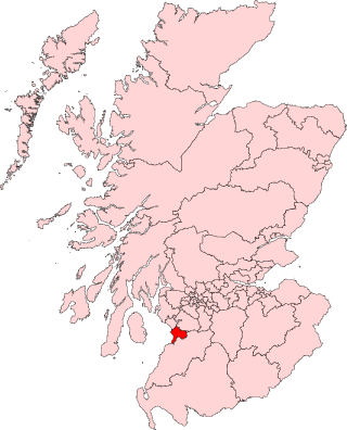
Ayrshire is a historic county and registration county, in south-west Scotland, located on the shores of the Firth of Clyde. The lieutenancy area of Ayrshire and Arran covers the entirety of the historic county as well as the island of Arran, formerly part of the historic county of Buteshire. Its principal towns include Ayr, Kilmarnock and Irvine and it borders the counties of Renfrewshire and Lanarkshire to the north-east, Dumfriesshire to the south-east, and Kirkcudbrightshire and Wigtownshire to the south. Like many other counties of Scotland, it currently has no administrative function, instead being sub-divided into the council areas of East Ayrshire, North Ayrshire and South Ayrshire. It has a population of approximately 366,800.

<span class="mw-page-title-main">South Ayrshire</span> Council area of Scotland

South Ayrshire is one of thirty-two council areas of Scotland, covering the southern part of Ayrshire. It borders onto Dumfries and Galloway, East Ayrshire and North Ayrshire. South Ayrshire had an estimated population in 2021 of 112,450, making it the 19th–largest subdivision in Scotland by population. With an area of 472 sq mi, South Ayrshire ranks as the 15th largest subdivision in Scotland.

<span class="mw-page-title-main">Ayr</span> Administrative centre and town in Scotland

Ayr is a town situated on the southwest coast of Scotland. A former royal burgh, today it is the administrative centre of the South Ayrshire Council, and the historic county town of Ayrshire. With a population of 46,982, Ayr is the 15th largest settlement in Scotland and second largest town in Ayrshire by population. The town is contiguous with the smaller town of Prestwick to the north. Ayr submitted unsuccessful bids for city status in 2000 and 2002, and as part of the wider South Ayrshire area in 2022.

<span class="mw-page-title-main">Cumnock</span> Town and former civil parish in Scotland

Cumnock is a town and former civil parish located in East Ayrshire, Scotland. The town sits at the confluence of the Glaisnock Water and the Lugar Water. There are three neighbouring housing projects which lie just outside the town boundaries, Craigens, Logan and Netherthird, with the former ironworks settlement of Lugar also just outside the town, contributing to a population of around 13,000 in the immediate locale. A new housing development, Knockroon, was granted planning permission on 9 December 2009 by East Ayrshire Council.

<span class="mw-page-title-main">Cumnock and Doon Valley</span> Local government district in Scotland

Cumnock and Doon Valley was one of nineteen local government districts in the Strathclyde region of Scotland from 1975 to 1996.

<span class="mw-page-title-main">Kyle and Carrick</span>

Kyle and Carrick was one of nineteen local government districts in the Strathclyde region of Scotland from 1975 to 1996.

<span class="mw-page-title-main">Kyle, Ayrshire</span>

Kyle is a former comital district of Scotland which stretched across parts of modern-day East Ayrshire and South Ayrshire. It is supposedly named after Coel Hen, a legendary king of the Britons, who is said to be buried under a mound at Coylton.

<span class="mw-page-title-main">Ayr, Carrick and Cumnock (UK Parliament constituency)</span> Parliamentary constituency in the United Kingdom, 2005 onwards

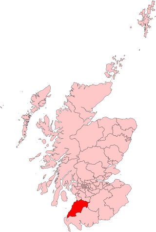
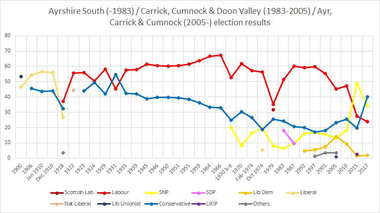
Ayr, Carrick and Cumnock is a county constituency represented in the House of Commons of the Parliament of the United Kingdom. It was created for the 2005 general election from parts of the old Ayr and Carrick, Cumnock and Doon Valley constituencies. It has been represented since 2024 by Elaine Stewart of Scottish Labour.

<span class="mw-page-title-main">Central Ayrshire (UK Parliament constituency)</span> Parliamentary constituency in the United Kingdom, 2005 onwards

Central Ayrshire is a constituency of the British House of Commons, located in the south-west of Scotland within the North Ayrshire and South Ayrshire council areas. It elects one Member of Parliament (MP) at least once every five years using the first-past-the-post system of voting.

<span class="mw-page-title-main">Kilmarnock and Loudoun (UK Parliament constituency)</span> Parliamentary constituency in the United Kingdom, 1983 onwards

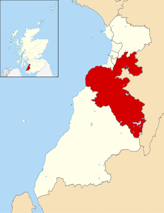
Kilmarnock and Loudoun is a county constituency of the House of Commons of the Parliament of the United Kingdom. It elects one Member of Parliament (MP), using the first-past-the-post voting system.

<span class="mw-page-title-main">Ayr (UK Parliament constituency)</span> Parliamentary constituency in the United Kingdom, 1950–2005

Ayr was a county constituency of the House of Commons of the Parliament of the United Kingdom from 1950 to 2005. It elected one Member of Parliament (MP) by the first-past-the-post system of election.

South Ayrshire was a county constituency of the House of Commons of the Parliament of the United Kingdom from 1868 until 1983, when it was abolished. It returned one Member of Parliament (MP), elected by the first past the post voting system.

<span class="mw-page-title-main">Ayr (Scottish Parliament constituency)</span> Constituency of the Scottish Parliament

Ayr is a burgh constituency of the Scottish Parliament (Holyrood) covering the town of Ayr in the council area of South Ayrshire. It elects one Member of the Scottish Parliament (MSP) via the plurality electoral system. It is also one of nine constituencies in the South Scotland electoral region which elects seven additional members to the Scottish Parliament via a proportional electoral system known as the Additional Members System which allows for greater accuracy in representation for the region as a whole.

<span class="mw-page-title-main">Carrick, Cumnock and Doon Valley (Scottish Parliament constituency)</span> Region or constituency of the Scottish Parliament

Carrick, Cumnock and Doon Valley is a county constituency of the Scottish Parliament at Holyrood, covering parts of the council areas of South Ayrshire and East Ayrshire. It elects one Member of the Scottish Parliament (MSP) by the plurality method of election. Also, it is one of nine constituencies in the South Scotland electoral region, which elects seven additional members, in addition to the nine constituency MSPs, to produce a form of proportional representation for the region as a whole.

<span class="mw-page-title-main">Cunninghame South (UK Parliament constituency)</span> Parliamentary constituency in the United Kingdom, 1983–2005

Cunninghame South was a constituency of the House of Commons of the Parliament of the United Kingdom from 1983 until 2005. It was represented by one Member of Parliament (MP) elected by the first-past-the-post system of election.

Doonfoot is a suburb in the south-west of Ayr, South Ayrshire.

<span class="mw-page-title-main">Kilmarnock and Irvine Valley (Scottish Parliament constituency)</span> Region or constituency of the Scottish Parliament

Kilmarnock and Irvine Valley is a constituency of the Scottish Parliament (Holyrood) covering part of the council area of East Ayrshire. It elects one Member of the Scottish Parliament (MSP) by the plurality method of election. It is also one of nine constituencies in the South Scotland electoral region, which elects seven additional members, in addition to the nine constituency MSPs, to produce a form of proportional representation for the region as a whole.

Mauchline was one of 32 electoral wards of East Ayrshire Council. Originally created in 1974, the ward was initially within Cumnock and Doon Valley District Council before the local government reforms in the 1990s. The ward elected one councillor using the first-past-the-post voting electoral system.

Patna and Dalrymple was one of 32 electoral wards of East Ayrshire Council. Originally created in 1974, the ward was initially within Cumnock and Doon Valley District Council before the local government reforms in the 1990s. The ward elected one councillor using the first-past-the-post voting electoral system.

<span class="mw-page-title-main">Maybole, North Carrick and Coylton (ward)</span> Electoral ward in South Ayrshire, Scotland

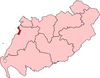
Maybole, North Carrick and Coylton is one of the eight electoral wards of South Ayrshire Council. Originally a four-member ward, Maybole, North Carrick and Coylton was reduced in size following a boundary review and has elected three councillors since the 2017 South Ayrshire Council election.

References

  1. "'Carrick, Cumnock and Doon Valley', June 1983 up to May 1997". ElectionWeb Project. Cognitive Computing Limited. Archived from the original on 11 March 2016. Retrieved 10 March 2016.
  2. 'Second Review of UK Parliament Constituencies (1969) South Ayrshire county constituency'
  3. 'Third Review of UK Parliament Constituencies (1983 - 1997) Carrick, Cumnock and Doon Valley county constituency'
  4. 'Fourth Review of UK Parliament Constituencies (1997-2005) Carrick, Cumnock and Doon Valley county constituency'
  5. 'Boundary Commission for Scotland UK Parliament 2005 onwards Central Ayrshire county constituency'
  6. "Archived copy" (PDF). www.bcomm-scotland.independent.gov.uk. Archived from the original (PDF) on 23 September 2015. Retrieved 22 May 2022.{{cite web}}: CS1 maint: archived copy as title (link)
  7. 'Boundary Commission for Scotland First Periodic Review of Scottish Parliament Boundaries Recommended Scottish Parliament constituencies Ayr County Constituency'
  8. Leigh Rayment's Historical List of MPs – Constituencies beginning with "A" (part 3)
  9. Leigh Rayment's Historical List of MPs – Constituencies beginning with "C" (part 3)
  10. "Election Data 1983". Electoral Calculus. Archived from the original on 15 October 2011. Retrieved 18 October 2015.
  11. "Election Data 1987". Electoral Calculus. Archived from the original on 15 October 2011. Retrieved 18 October 2015.
  12. "Election Data 1992". Electoral Calculus. Archived from the original on 15 October 2011. Retrieved 18 October 2015.
  13. "Election Data 1997". Electoral Calculus. Archived from the original on 15 October 2011. Retrieved 18 October 2015.
  14. "Election Data 2001". Electoral Calculus. Archived from the original on 15 October 2011. Retrieved 18 October 2015.