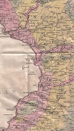
Monkton is a small town[3] in the parish of Monkton and Prestwick in South Ayrshire, Scotland. The town of Prestwick is around 1+1⁄2 miles (2.5 kilometres) south of the village, and it borders upon Glasgow Prestwick Airport.
The town was originally known as Prestwick Monachorum.[4]
The Windmill
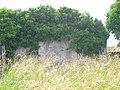
The tower-like building on the hill was originally a windmill and later a doocot. It is not to be confused with the structure on the opposite side of Prestwick Airport runway, the Shaw Monument, which was originally used by the then landowner to follow hunting with falcons on his land.[5] This vaulted windmill dates from the 17th century, converted to a dovecot in the 18th century when conical slated roof slot for potence and fireclay nesting boxes added. It had two doorways, one blocked.[6]
Views of the area
old Windmill; also called the Dovecot.
The MacRae of Orangefield Memorial above the Dutch Barn Caravan Park.
Fairfield Lodge.
Monktonhead Lodge. The driveway to Monktonhead House has been truncated by the bypass.
Climate
Monkton has an oceanic climate (Köppen: Cfb). The nearest weather station to Monkton is at Prestwick Airport, around 1km (5⁄8mi) east, and is 27m (89ft)above sea level.
Climate data for Prestwick RNAS (27 m asl, averages 1981–2010)
The church was dedicated to St. Cuthbert and dates from the 13th century.[8] It was in use up until 1837,[4] being suppressed by the Court of Teinds in 1834 and a new united church built near the Pow Burn. The poet Robert Burns' nephew, the Rev Thomas Burns was instrumental in the building of the new church and for a time it was locally known as "Burns's Folly".[9] Burns also wrote the Statistical Account of the parish.[10] It was in Monkton church that Blind Harry's poem The Actes and Deidis of the Illustre and Vallyeant Campioun Schir William Wallace bases the story that William Wallace went to pray, fell asleep and had an inspirational dream which revived his flagging resolve to rescue Scotland from Edward I.[11]
Views of Monkton church and cemetery
The south side.
The 17th century northern transept.
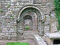
The ornate 17th century entrance to Saint Cuthbert church.
An ornate carved cross on the 17th century transept.
The mausoleum of William Weir of Adamton and Kildonan.
The Angus of Ladykirk aisle.
Monkton station
Monkton station opened on 5 August 1859 as part of the Glasgow, Paisley, Kilmarnock and Ayr Railway, later the Glasgow and South Western Railway. The station, now represented by the Prestwick airport fuel unloading sidings, was closed on 28 October 1940 by the London, Midland and Scottish Railway, therefore not even surviving into British Railways. The closest railway station to the town today is Prestwick International Airport Railway Station, which opened in 1994.
Fairfield House
The old walled garden.The cemetery gates
Colonel William Fullarton of that Ilk had owned Fairfield, however he sold it before he took up an appointment in Trinidad circa 1803.[12] The property was held in 1851 by William Gunning Campbell at which time the house had a housekeeper, an undergardner, and two housemaids, in addition to the gardener and his laundress wife who lived at Fairfield Cottage.[13] The property had a walled garden which survives as a ruin (2025) and a cemetery garden which remains in fair condition; the old Scottish unit of land measurement called a "fall" is recorded in the inscription. The last Campbell to live at the estate was W. G. Campbell and from the 1860s the property was run by trustees. Fairfield had been known as "Overmains" and had been a part of the lands of Monkton Castle, latterly known as Monkton House.[14]
In the 1860s James Sinclair of Orangefield died and this 106-acre (43-hectare) estate was added to the 685 acres (277 hectares) of Fairfield. The associated farms were Fairfield Mains, Monktonmiln, Muirhouse, Orangefield and West Orangefield.[15] Fairfield was sold in 1950 and demolished by the new owner who had planned to build villas and racing stables.[16]
Campbell family Cemetery Garden and Lodge
The 1835 dedication stone
The '2 falls' cemetery garden Christian dedication stone.
The 'Jesus wept' gravestone and inscription of William and Diana Campbell
Monkton House was rebuilt by James MacRae (1684–1746) who had been the President of Madras, 1725–1730 and came back with a fortune amounting to £100,000. He purchased the estate of Monkton in 1736[17] and renamed the house 'Orangefield' as he was a great admirer of William of Orange, William III; he died here in 1746[18]
The MacRae monument
The MacRae Monument or 'Orangefield Family Burial Ground' near the village was built around 1750 by John Swan and is of the Corinthian style, with alcove, urns and obelisk.[8] The site has been referred to as the Orangefield family burial-plot.[17]
This page is based on this Wikipedia article Text is available under the CC BY-SA 4.0 license; additional terms may apply. Images, videos and audio are available under their respective licenses.