Carleton Castle

Last updated

Carleton Castle
Lendalfoot, South Ayrshire, Scotland
UK grid reference NX 13302 89521
Carleton Castle tower ruins from the south-east, Little Carleton Farm, Lendalfoot, South Ayrshire.jpg
Remnants of the castle's keep
Scotland relief location map.jpg
Red pog.svg
Carleton Castle
Coordinates 55°09′53″N4°55′57″W / 55.1647°N 4.9325°W / 55.1647; -4.9325
TypeA tower castle and barmakin
Site information
OwnerLittle Carleton Farm
Open to
the public
No
ConditionA ruin
Site history
Built15th century
Built byCathcarts of Killochan
In use15th to early 18th century
MaterialsStone

The ruins of the five storey high 15th century Carleton Castle lie in a prominent position above the village of Lendalfoot located on Carleton Bay, parish of Colmonell in the old district of Carrick, now South Ayrshire, about 6 miles (9.7 Km) south of Girvan, Scotland. [1]

Contents

History

Carleton Castle and Little Carleton Fort or Motte

The Little Carleton Motte. Carleton Motte from Little Carleton Farm, Lendalfoot, South Ayrshire.jpg
The Little Carleton Motte.

Carleton Castle is a Category B Listed Building of the 15th-century five-storey tower and barmakin, once held by the Cathcarts of Killochan [2] that stands overlooking the village close to the Games Loup cliffs. The long abandoned tower ruins still stand, minus the parapet and a collapsed section of wall that has been partly rebuilt at some more recent stage with internal plastering applied that suggests a later use as a dwelling or store. At the back of the tower pigsties-type ruins survive that were still roofed in the 19th century according to OS maps. This small tower had only one private apartment reached via a stair from a window in the great hall, the entry to the oblong tower itself being originally via a door at first floor level with a wooden ladder or stair. The six-foot-thick (1.8 m) wall at the entrance may have had a stair within it that gave access to the cellar, great hall and a probable kitchen level. In the south-east corner a wheel stair connected the hall to the cellar. [3] A prominent feature on the side facing the farm is a garderobe or privy shute.

The barmakin or walled courtyard existed with towers at the angles on the area between the two relatively deep glens created by small un-named rivulets. [4] [5] The castle guarded and controlled a mountain pass as well as the old road Portpatrick road that then ran along the high ground. [4] The tower had two vaults, one over the great hall and the second over the ground floor. 19th century engravings show that substantially more of the great hall vaulted ceiling survived at that time. [5] [6] Red sandstone appears to have been selectively used as a decorative feature in the upper vault, window arches, etc.

Details of the upper storey of the tower Carleton Castle ruin construction details, Little Carleton Farm, Lendalfoot, South Ayrshire.jpg
Details of the upper storey of the tower

Blaeu's map of the 1660s shows the castle as intact with a pale or fence on the side of the castle not demarcated by the two deep glens. A Karltoun Mill and Mains are shown, both probably associated with the Cathcarts as lairds, the mains farm being, as was usually the case, set aside for supplying food to the laird, his family and servants. [7] John Adair records the castle in his map of 1685. [8] Herman Moll's map of 1745 records Karleton (sic) and shows the old inland road to Portpatrick running close by. [9] In 1775 Carlton (sic) is shown, not seemingly as a ruin, with the Portpatrick road now following the coastline. [10] The 1775 road map by Taylor and Skinner is the first to clearly record the castle as a ruin although still held by a Cathcart baronet. [11]

Carleton is typical of the other Carrick castles such as Dinvin, Dow Hill, Duniewick. The Cathcarts also held Little Rigend and Camregan castles in East Ayrshire. [4]

Little Carleton Motte

A substantial 5-metre-high (16 ft) earth mound, 20 metres across, is known as the Little Carleton Fort or Motte with a circular ditch and a once palisaded bank built some centuries prior to the stone castle stands across from Little Carleton Farm, damaged by the construction of the lane to the village. It was also held by the Cathcarts. [4] Standing close to the castle the motte may have served as the moot hill where the laird's barony court met. No place name evidence for a gallows hill has been noted. [12] [3]

Carleton's name may derive from 'carl or churl' the serfs' dwelling, however in the Whithorn Priory records it is recorded as 'Cairiltoun', the 'dwelling of the Cairils' who in 1095 it is said emigrated from County Antrim to Carrick. [13]

The legend of Sir John Cathcart and the murdered heiresses

Carleton Castle tower showing the collapsed area and rebuilt section with new entry door. Carleton Castle ruin from the north-east, Little Carleton Farm, Lendalfoot, South Ayrshire.jpg
Carleton Castle tower showing the collapsed area and rebuilt section with new entry door.

A legend derived from the ballad May or Mary Culzean [14] exists in several versions in different books. [15] The essence of the story is that Sir John Cathcart of Carleton Castle was in the habit of enriching his estate through marrying heiresses. The steep Games Loup cliffs stand close to the castle and one by one his brides met their end by accidentally falling from the path that ran along the edge.

Mary Kennedy of Culzean was Sir John's ninth heiress bride and one evening whilst walking along the Games Loup her husband informed her that she was to meet her end, but that he would keep her valuable jewel and gold thread enriched clothes. Mary told her husband to act like a gentlemen and to turn his back to preserve her dignity whilst she undressed. Upon his turning she grabbed his arm, spun him around and cast him off the cliff to his death. [16] The ghostly screams of Sir John or his eight murdered wives are said to have been heard emanating from the castle. [17] [18]

The Cathcart lairds

A John Cathcart of Carleton did exist, however he lived at Killochan Castle and it is not known how the legend became attached to his name. John's wife was Helen Wallace and he had at least two sons, John and Robert who were probably born at Killochan Castle. [19] [20] Robert Cathcart is considered to have been the author of the scholarly "Historie of Kennedyis". [21]

Carleton was a possession of the Cathcarts from the time of King Robert I (11 July 1274 – 7 June 1329) and in the 1860s Sir Reginald Cathcart of Killochan had charters dated 1324 and another from King Robert II dated 1386. [5]

The Lousey or Lausey Knowe

On the south side of the Lendal Water stands an artificial mound that is recorded as the Lousey or Lausey Knowe. A local tradition has it that the women of the district used this site to de-louse their children's hair whilst another interpretation is that the name derives from the Scots language for a fire or signal hill, linked to the security and military activities of the castle. [22]

Carleton Hill

Carleton Hill rises to 520 feet or 158 metres from the coastal road and is the site near its summit of earth banks, a probable ancient fort. [1] [23]

Related Research Articles

<span class="mw-page-title-main">Maybole</span> Human settlement in Scotland

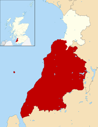
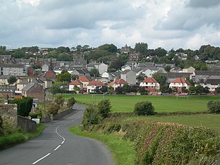
Maybole is a town and former burgh of barony and police burgh in South Ayrshire, Scotland. It had an estimated population of 4,580 in 2020. It is situated 9 miles (14 km) south of Ayr and 50 miles (80 km) southwest of Glasgow by the Glasgow and South Western Railway. The town is bypassed by the A77.

<span class="mw-page-title-main">Busbie Castle</span>

Busbie Castle was situated in what is now known as Knockentiber, a village in East Ayrshire, Parish of Kilmaurs, Scotland. Knockentiber is 2 miles (3.2 km) WNW of Kilmarnock and 1/2 mile NE of Crosshouse. The castle overlooked the Carmel Glen and its Burn, which runs into the River Irvine, a mile or so to the south, after passing through the old Busbie Mill.

<span class="mw-page-title-main">Craigie Castle</span>

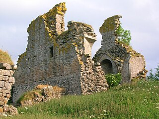
Craigie Castle, in the old Barony of Craigie, is a ruined fortification situated about 4 miles (6.4 km) southeast of Kilmarnock and 1 mile (1.6 km) southeast of Craigie village, in the Civil Parish of Craigie, South Ayrshire, Scotland. The castle is recognised as one of the earliest buildings in the county. It lies about 1.25 miles (2 km) west-south-west of Craigie church. Craigie Castle is protected as a scheduled monument.

<span class="mw-page-title-main">Dunduff Castle</span> Castle in Ayrshire, Scotland

Dunduff Castle is a restored stair-tower in South Ayrshire, Scotland, built on the hillside of Brown Carrick Hills above the Drumbane Burn, and overlooking the sea above the village of Dunure.

<span class="mw-page-title-main">Terringzean Castle, East Ayrshire</span>

Terringzean Castle, also Taringzean, pronounced 'Tringan', is a Category B listed castle ruin lying above the River Lugar and the Terringzean Holm in the policies of Dumfries House, Parish of Cumnock, Scotland. The name Craufordstone or Craufurdstoun, has also been used, echoing that it and these lands originally belonged to the Crawfords, as did Lefnoreis Castle or Lochnorris Castle which once stood near the site of the Dumfries House stables.

<span class="mw-page-title-main">Loch of Trabboch</span> Body of water

The Loch of Trabboch or Dalrympleston Loch (NS440211) was situated in a low-lying area below the old Castle of Trabboch, once held by the Boyd family in the Parish of Stair, East Ayrshire, Scotland.

Trabboch Castle is a ruined L-plan tower house in the old Barony of Trabboch, Parish of Stair, East Ayrshire, Scotland.

<span class="mw-page-title-main">Killochan Castle</span>

Killochan Castle is a 16th-century L-plan tower house about 3 miles (4.8 km) north east of Girvan, South Ayrshire, Scotland, north of the Water of Girvan, and south of Burnhead.

<span class="mw-page-title-main">Killochan railway station</span> Former railway station in Scotland

Killochan railway station was located in a rural part of South Ayrshire, Scotland and mainly served the nearby Killochan Castle estate. The Killochan bank is the name given to this section of the line, running from Girvan on an uphill gradient to just north of the old station site. Maybole is around nine miles away and Girvan two miles.

<span class="mw-page-title-main">Alloway Mote</span> Medieval castle in South Ayrshire, Scotland

The Scheduled Ancient Monument of Alloway Mote, also known as the Alloway Moat or Alloway Motte, is a roughly circular earthwork that is regarded as a possible early medieval ringwork, located near the village of Alloway in South Ayrshire, Scotland.

<span class="mw-page-title-main">Craigie, South Ayrshire</span> Human settlement in Scotland

Craigie is a small village and parish of 6,579 acres in the old district of Kyle, now South Ayrshire, four miles south of Kilmarnock, Scotland. This is mainly a farming district, lacking in woodland, with a low population density, and only one village. In the 19th century, high quality lime was quarried here with at least three sites in use in 1832.

<span class="mw-page-title-main">Lendalfoot</span> Human settlement in Scotland

Lendalfoot is a small village located on Carleton Bay, parish of Colmonell in the old district of Carrick, now South Ayrshire, about six miles south of Girvan, Scotland. This is mainly a farming district, lacking in woodland, with a low population density. The village sits astride the A77 that runs north to Girvan and south to Cairnryan and Stranraer. Carleton Hill rises to 520 feet or 158 metres from the road and is the site near its summit of earth banks, an ancient fort.

<span class="mw-page-title-main">Minishant</span> Human settlement in Scotland

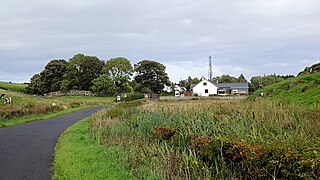
Minishant is a village bordering the A77 in the old county of Carrick, South Ayrshire, Scotland. It is located in Maybole Parish, 3+12 miles from Maybole and standing close to the River Doon. The village was originally named Culroy after the Culroy Burn that runs through it.

Gilbert Kennedy of Bargany and Ardstinchar was a Scottish landowner and murder victim. Kennedy had inherited a long-standing family feud with John Kennedy, 5th Earl of Cassilis, on the death of his father, Thomas Kennedy of Bargany. On 11 December 1601 he met the Earl and his followers at Pennyglen near Maybole and was murdered with a lance thrust in his back.

<span class="mw-page-title-main">Kyle Castle</span>

The ruins of the large courtyard style Kyle Castle, once also known as Cavil Castle or occasionally Dalblair Castle lie close to the hamlet of Dalblair in Auchinleck parish near Muirkirk in the East Ayrshire council area, Scotland. The castle stands at the confluence of the Guelt Water and the Glenmuir Water on a peninsula carved out by these rivers. Its name suggests that it was once of some significance.

<span class="mw-page-title-main">Castle and Barony of Gadgirth</span>

The Castle and Barony of Gadgirth was held by the Chalmer family, originally De Camera, with successive castles and a mansion house overlooking the River Ayr at the border of the Parish of Coylton, the old district of Kyle, now part of South Ayrshire, Scotland.

<span class="mw-page-title-main">Lawthorn</span> Human settlement in Scotland

Lawthorn is a hamlet near Perceton in Strathannick, Irvine, North Ayrshire, Scotland. The settlement lies on the old Irvine to Stewarton toll road.

The Lands of Dallars or Auchenskeith (NS463337) form a small estate in East Ayrshire, Hurlford, Kilmarnock, Parish of Riccarton, Scotland. The present mansion house is mainly late 18th-century, located within a bend of the Cessnock Water on the site of older building/s. "Dullers or Dillers" was changed to "Auchenskeith" or "Auchinskeigh" (sic) as well as other variants and then the name reverted nearer to the original form as "Dollars" and then finally "Dallars". Dallars lies 3.25 km south of Hurlford.

<span class="mw-page-title-main">Maybole Castle</span> Castle in South Ayrshire, Scotland

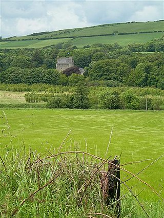
Maybole Castle is a 16th-century castle located on High Street in Maybole, South Ayrshire, Scotland. Originally built for the Earls of Cassillis, it is an L-shaped construction with Victorian two-storey extensions. It is associated with a legend of John Faa, in which an earl killed Faa and imprisoned his wife, the Countess of Cassilis, in the castle.

References

Notes
  1. 1 2 Francis H. Groome (1886). Ordnance Gazetteer of Scotland. Vol.1. Edinburgh : Thomas C. Jack. p. 236.
  2. British Listed Buildings - Carleton Castle
  3. 1 2 Mike Salter (2006). The Castles of South-West Scotland. Malvern:Folly Publications. p. 31.
  4. 1 2 3 4 Thorbjorn Campbell (2003). Ayrshire. A Historical Guide. Edinburgh:Birlinn. p. 150.
  5. 1 2 3 MacGibbon, T. and Ross, D. (1887). The castellated and domestic architecture of Scotland from the twelfth to the eighteenth centuries. Edinburgh:James Thin. p. 209.{{cite book}}: CS1 maint: multiple names: authors list (link)
  6. Carleton Castle in 1951
  7. Blaeu Atlas Maior 1662-5, Volume 6. Carricta Meridionalis
  8. A mape of the west of Scotland containing Clydsdail, Nithsdail, Ranfrew, Shyre of Ayre, & Galloway / authore Jo. Adair.
  9. The South Part of the Shire of Air, containing Kyle and Carrick / by H. Moll
  10. Andrew Armstrong - A New Map of Ayrshire
  11. G Taylor and A Skinner's Survey and maps of the roads of North Britain or Scotland, 1776
  12. Thorbjorn Campbell (2003). Ayrshire. A Historical Guide. Edinburgh:Birlinn. p. 151.
  13. James B. Johnston (1934). PLace Names of Scotland. London : John Murray. p. 125.
  14. The historical ballad of May Culzean : founded on fact. With, A poem on the times.
  15. Dane Love (2009). Legendary Ayrshire. Custom : Folklore : Tradition. Carn. p. 205.
  16. Anna Blair (1983). Tales of Ayrshire. Shepheard-Walwyn. p. 28.
  17. Scottish Places - Carleton Castle
  18. Haunted Castles Ghost Hauntings Sorted by Name
  19. Sir James Ferguson (2004). By the Water of Girvan. The Grimsay Press. p. 86.
  20. Sir James Ferguson (2004). By the Water of Girvan. The Grimsay Press. p. 88.
  21. Sir James Ferguson (2004). By the Water of Girvan. The Grimsay Press. p. 94.
  22. John Smith (1895). Prehistoric Man in Ayrshire. London:Elliot Stock. p. 218.
  23. Francis H. Groome (1886). Ordnance Gazetteer of Scotland. Vol.IV. Edinburgh : Thomas C. Jack. p. 494.
Sources
  1. Campbell, Thorbjørn (2003). Ayrshire. A Historical Guide. Edinburgh : Birlinn. ISBN   1-84158-267-0
  2. Dobie, James D. (ed Dobie, J.S.) (1876). Cunninghame, Topographized by Timothy Pont 1604–1608, with continuations and illustrative notices. Glasgow: John Tweed.
  3. Love, Dane (2003). Ayrshire : Discovering a County. Ayr : Fort Publishing. ISBN   0-9544461-1-9.
  4. Love, Dane (2009). Legendary Ayrshire. Custom : Folklore : Tradition. Auchinleck : Carn.
  5. MacKenzie, W.C. (1931). Scottish Place-Names. London : Kegan Paul.
  6. Salter, Mike (2006). The Castles of South-West Scotland. Malvern : Folly Publicationa.
  7. Smith, John (1895). Prehistoric Man in Ayrshire. London : Elliot Stock.