Stair is a village in Ayrshire, Scotland. It lies at the bottom of a glen beside the River Ayr at the north-west border of the 5,376 acre (22 km2) Parish of Stair where the River Ayr is joined by the Glenstang Burn.

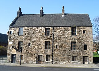
The Provand's Lordship of Glasgow, Scotland, is a medieval historic house museum located at the top of Castle Street within sight of the Glasgow Cathedral and Glasgow Royal Infirmary, and next to the St Mungo Museum of Religious Life and Art.

Thomaston Castle is a medieval castle located west of Maybole, South Ayrshire, Scotland. It looks much as it did hundreds of years ago. Little has changed, except for the addition of a house located on the property. The castle is run down and has debris falling in on it.

Lochend is a mainly residential suburb of Edinburgh, the capital of Scotland. It is named after Lochend Castle and the adjacent Lochend Loch, located in the western part of Restalrig on the boundary between Leith and The Canongate, approximately two miles from Edinburgh city centre. The suburb consists largely of a 1930s public housing estate, and is bounded on the west by Easter Road.
The Paibian is the lowest stage of Furongian series of the Cambrian. It follows the Guzhangian and is succeeded by the Jiangshanian Stage. The base is defined as the first appearance of the trilobite Glyptagnostus reticulatus around 497 million years ago. The top, or the base of the Jiangshanian is defined as the first appearance of the trilobite Agnostotes orientalis around 494 million years ago.
Honolulu Waldorf School, established in 1961, is a coeducational, independent school serving more than 300 children from early childhood through middle school located on the island of Oahu in the State of Hawaii. It previously included high school levels.

Ampudia is a municipality located in the province of Palencia, Castile and León, Spain. According to the 2004 census (INE), the municipality has a population of 677 inhabitants.
A moot hill or mons placiti is a hill or mound historically used as an assembly or meeting place, as a moot hall is a meeting or assembly building, also traditionally to decide local issues. In early medieval Britain, such hills were used for "moots", meetings of local people to settle local business. Among other things, proclamations might be read; decisions might be taken; court cases might be settled at a moot. Although some moot hills were naturally occurring features or had been created long before as burial mounds, others were purpose-built.

Rufus Castle, also known as Bow and Arrow Castle, is a partially ruined castle overlooking Church Ope Cove on Portland, England. Its name derives from King William II, known as William Rufus, for whom the original castle was built.

Rutherglen Castle was located where Castle Street meets King Street in Rutherglen, Scotland. It was a large and important castle, having been built in the 13th century; the walls were reportedly 5 feet thick.

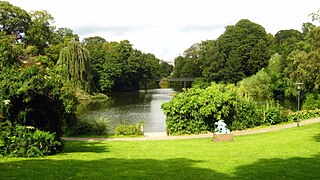
Copenhagen is a green city well endowed with open spaces. It has an extensive and well-distributed system of parks that act as venues for a wide array of events and urban life. As a supplement to the regular parks, there are a number of congenial public gardens and some cemeteries doubling as parks. It is official municipal policy in Copenhagen that all citizens by 2015 must be able to reach a park or beach on foot in less than 15 minutes.
Banner Marsh State Fish and Wildlife Area is an Illinois state park covering 4,363 acres (1,766 ha) in Fulton County, Illinois, United States.

Glenapp Castle, formerly the family seat of the Earl of Inchcape, is now a luxury hotel and restaurant located about 1+1⁄2 miles southeast of Ballantrae, South Ayrshire, Scotland.

Barnweill Church or Barnweil Church is a ruined pre-reformation kirk situated on rising ground on the slopes of Barnweill Hill, Parish of Craigie, South Ayrshire, Scotland; about 3 km from Tarbolton. The church was known locally as the "Kirk in the Wood". It lies about 170m North North-East of Kirkhill Farm. Barnweill was central to the Protestant Reformation in Ayrshire through its association with John Knox. The spelling 'Barnweill' is used throughout for consistency.

Sorn Castle is located by the River Ayr just outside the village of Sorn in East Ayrshire, Scotland. The castle comprises a medieval tower house, which was extended over the years, and remodelled in the Scots Baronial style by David Bryce in the 1860s. The castle is protected as a category A listed building.

Wallace's Monument, the Wallace Tower, or the Barnweil Monument is a category-A-listed building dedicated to the memory of William Wallace located on Barnweil Hill, a prominent location in the parish of Craigie, South Ayrshire, Scotland.
Wigtown Castle was a royal castle that was located on the banks of the River Bladnoch, south of Wigtown in Dumfries and Galloway, Scotland.
Swindridgemuir House and estate were composed of the 'Lands of Swindridgemuir' and the dwelling house about two miles north-east of Dalry in the old Barony of Kersland, about a mile and a half north of the Blair Estate, North Ayrshire, Scotland. The spelling on the family memorials at Ayr Auld Kirk is 'Swindrigemuir'.

Inch Castle is a ruined castle located on the southern tip of Inch Island in County Donegal in Ulster, the northern province in Ireland. The castle was constructed around 1430 by the Gaelic Irish lord Neachtain O'Donnell for his father-in-law, Cahir O'Doherty. The Ó Dochartaigh (O'Doherty) clan were the dominant family on the nearby peninsula of Inishowen and had close links with the O'Donnells. It came to form part of the defensive network of O'Doherty fortifications designed to protect them from rival clans and to overawe those who accepted their overlordship.


