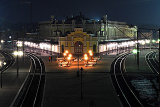
Koziatyn is a town in the Vinnytsia Oblast (province) of western Ukraine. Serving as the administrative center of the Koziatyn Raion (district), the town itself is not a part of the district and is separately incorporated as the town of oblast significance, and is located 75 kilometres (47 mi) from oblast capital, Vinnytsia, at around 49°43′00″N28°50′00″E. It lies on the banks of the Huyva River. Population: 24,175 (2015 est.)
East Pine Provincial Park is a provincial park in British Columbia, Canada, located east of Chetwynd in the Peace River Block at the junction of the Pine and Murray Rivers. The park was established in 1982 and is 14.2 hectares in size.

Great Glacier Provincial Park is a provincial park in British Columbia, Canada, created to protect the Great Glacier, one of the major sights along the lower Stikine River. The park lies on the river's west (right) bank inland from the British Columbia-Alaska boundary, which lies a few miles downstream. Immediately across the river from the Great Glacier and its park is Choquette Hot Springs Provincial Park, which protects the Stikine River Hot Springs. Both parks are in the traditional territory of the Tahltan people. and lie about 120 km southwest of the Tahltan community of Telegraph Creek, which lies at the upper, opposite, end of the Grand Canyon of the Stikine from the area of the Great Glacier.
Ruth Lake Provincial Park is a provincial park in British Columbia, Canada, located northeast of 100 Mile House.
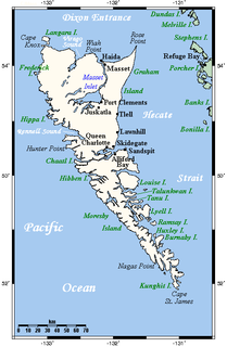
The San Christoval Range is a 50 km long, jagged mountain range located on the west coast of Moresby Island, British Columbia, Canada. It is the only lineal mountain range in the Queen Charlotte Mountains and the highest peaks are just above 1000 m. The mountain range was named by Juan José Pérez Hernández in 1774.
The Alkali Lake Indian Band, also known as the Esketemc First Nation, is a First Nations government of the Secwepemc (Shuswap) people, located at Alkali Lake in the Cariboo region of the Central Interior of the Canadian province of British Columbia. It was created when the government of the then-Colony of British Columbia established an Indian Reserve system in the 1860s. It is one of three Secwepemc bands that is not a member of either the Shuswap Nation Tribal Council or the Northern Shuswap Tribal Council.
The Lytton First Nation, a First Nations government, has its headquarters at Lytton in the Fraser Canyon region of the Canadian province of British Columbia. While it is the largest of all Nlaka'pamux bands, unlike all other governments of the Nlaka'pamux (Thompson) people, it is not a member of any of the three Nlaka'pamux tribal councils, which are the Nicola Tribal Association, the Fraser Canyon Indian Administration and the Nlaka'pamux Nation Tribal Council.
The Kluskus First Nation is the band government of the Lhoosk’uz, a Dakelh people whose main reserve located on the Chilcotin Plateau 130 km west of the city of Quesnel, British Columbia, Canada. The First Nation is a member of the Carrier-Chilcotin Tribal Council, which includes both Tsilhqot'in and Carrier (Dakelh) communities.
The Porcupine River is a left tributary of the Stikine River in northwestern British Columbia, Canada, entering that stream south of the confluence of the Anuk River and above the confluence of the Iskut.
Sea Bird Island is an island in the Fraser River just east of Agassiz, British Columbia, Canada, in the Upper Fraser Valley region of that province, about 75 miles east of Vancouver. Though within the District of Kent, most of the island is the Seabird Island Indian Reserve and is the community of the Seabird Island First Nation, a member government of the Sto:lo Tribal Council.
Kimsquit is a former village of the Nuxalk at the mouth of the Dean River on the northeast side of Dean Channel in the Central Coast region of British Columbia, Canada. Kemsquit Indian Reserve No. 1 is nearby at 52°49′00″N126°58′00″W, which is on Kimsquit Bay; Kimsquit Mountain is nearby.

Grenville Channel is a strait on the North Coast of British Columbia, Canada, located between Pitt Island and the mainland to the south of Prince Rupert. It is part of the Inside Passage shipping route.
Darwin Sound is a sound in the Queen Charlotte Islands of British Columbia, Canada. It is located between Moresby Island (W) and Lyell Island (E) and was named in 1878 by Canada's then-Chief Geographer George M. Dawson in honour of Charles Darwin, the eminent naturalist.
Goose Lake refers to several lakes in close vicinity in Halifax County, Nova Scotia, Canada.
The Tower of London Range is a sub-range of the Northern Rocky Mountains in northern British Columbia, Canada, located northwest of the Tuchodi Lakes at the northwest end of the Northern Rocky Mountains Provincial Park to the southwest of Fort Nelson.
Pooley Island is an island in the North Coast region of British Columbia, Canada. To its west and southwest is Roderick Island, to its east Mathieson Channel. James Johnstone, one of George Vancouver's lieutenants during his 1791-95 expedition, first charted its north and east coasts in 1793. The island was later named after Charles Edward Pooley.
Atnarko is a locality on the Atnarko River, at the south end of Tweedsmuir Provincial Park in the Bella Coola Valley region of British Columbia, Canada. The original name of the post office located here was Anaham, a name associated with the Tsilhqot'in people of the neighbouring Chilcotin Country region. Opened under that name in 1907, it was changed to Atnarko in 1913, with the post office itself closing in 1932.
Jedway is a landing and erstwhile settlement and mining camp on Harriet Harbour, part of Skincuttle Inlet, on the east coast of Moresby Island in Haida Gwaii, British Columbia, Canada. Jedway was once a hub for mines in the area during a mining boom on South Moresby, including mines at Ikeda and Lockeport, though a mine at the Jedway iron-magnetite deposit, known as the Jessie showings, did not open until 1961. In the earlier period, Jedway had been the "capital" of the Queen Charlotte Islands until that (the headquarters of the provincial Gold Commissioner, E.M. Sandilands, whose position carried with it all the functions of and powers of government, to Queen Charlotte City in 1910. A 1908 in The Ledge, a mining newspaper based in Greenwood, said "there is room for another hotel in Jedway". Jedway remained a local service centre after that, however, with two Chinese sentenced to months-long imprisonment being relocated there from Queen Charlotte City in 1912 indicating the presence of jail facilities there.
Lipovtsy is an urban locality in Oktyabrsky District, Primorsky Krai, Russia. Population: 6,402 (2010 Census); 6,742 (2002 Census);