Related Research Articles
The Detroit River flows west and south for 24 nautical miles from Lake St. Clair to Lake Erie as a strait in the Great Lakes system. The river divides the metropolitan areas of Detroit, Michigan, and Windsor, Ontario—an area collectively referred to as Detroit–Windsor—and forms part of the border between Canada and the United States. The Ambassador Bridge, the Detroit–Windsor Tunnel, and the Michigan Central Railway Tunnel connect the cities.

The Athabasca River is a river in Alberta, Canada, which originates at the Columbia Icefield in Jasper National Park and flows more than 1,231 km (765 mi) before emptying into Lake Athabasca. Much of the land along its banks is protected in national and provincial parks, and the river is designated a Canadian Heritage River for its historical and cultural importance. The scenic Athabasca Falls is located about 30 km (19 mi) upstream from Jasper.

The Mackenzie River is a river in the Canadian boreal forest. It forms, along with the Slave, Peace, and Finlay, the longest river system in Canada, and includes the second largest drainage basin of any North American river after the Mississippi.
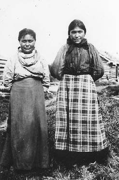
The Slavey are a First Nations indigenous peoples of the Dene group, indigenous to the Great Slave Lake region, in Canada's Northwest Territories, and extending into northeastern British Columbia and northwestern Alberta.

Lake Athabasca is in the north-west corner of Saskatchewan and the north-east corner of Alberta between 58° and 60° N in Canada. The lake is 26% in Alberta and 74% in Saskatchewan.

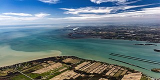
Great Slave Lake, known traditionally as Tıdeè in Tłı̨chǫ Yatıì (Dogrib), Tinde’e in Wıìlıìdeh Yatii / Tetsǫ́t’ıné Yatıé, Tu Nedhé in Dëne Sųłıné Yatıé (Chipewyan), and Tucho in Dehcho Dene Zhatıé (Slavey), is the second-largest lake in the Northwest Territories of Canada, the deepest lake in North America at 614 m (2,014 ft), and the tenth-largest lake in the world by area. It is 469 km (291 mi) long and 20 to 203 km wide. It covers an area of 27,200 km2 (10,500 sq mi) in the southern part of the territory. Its given volume ranges from 1,070 km3 (260 cu mi) to 1,580 km3 (380 cu mi) and up to 2,088 km3 (501 cu mi) making it the 10th or 12th largest by volume.

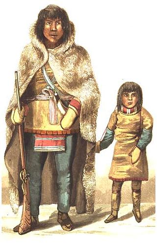
The Dene people are an indigenous group of First Nations who inhabit the northern boreal and Arctic regions of Canada. The Dene speak Northern Athabaskan languages. Dene is the common Athabaskan word for "people". The term "Dene" has two usages. More commonly, it is used narrowly to refer to the Athabaskan speakers of the Northwest Territories and Nunavut in Canada, especially including the Chipewyan (Denesuline), Tlicho (Dogrib), Yellowknives (T'atsaot'ine), Slavey, and Sahtu. However, it is sometimes also used to refer to all Northern Athabaskan speakers, who are spread in a wide range all across Alaska and northern Canada. The Southern Athabaskan speakers, however, also refer to themselves by similar words: Diné (Navajo) and Indé (Apache).

The Slave River is a Canadian river that flows from the confluence of the Rivière des Rochers and Peace River in northeastern Alberta and empties into Great Slave Lake in the Northwest Territories. The river's name is thought to derive from the name for the Slavey group of the Dene First Nations, Deh Gah Got'ine, in the Athabaskan language. The Chipewyan had displaced other native people from this region.

The Coppermine River is a river in the North Slave and Kitikmeot regions of the Northwest Territories and Nunavut in Canada. It is 845 kilometres (525 mi) long. It rises in Lac de Gras, a small lake near Great Slave Lake, and flows generally north to Coronation Gulf, an arm of the Arctic Ocean. The river freezes in winter but may still flow under the ice.

The Mackenzie Northern Railway is a 602-mile (969 km) Canadian railway operating in Alberta and the Northwest Territories. It is the northernmost trackage of the contiguous North American railway network. Since being purchased by CN in 2006, it has been officially known as the Meander Subdivision.

Fort Resolution is a hamlet in the South Slave Region of the Northwest Territories, Canada. The community is situated at the mouth of the Slave River, on the shores of Great Slave Lake, and at the end of the Fort Resolution Highway. It is the headquarters of the Deninu Kųę́ First Nation, whose Chief is Louis Balsillie.

Lake Claire is the largest lake which is entirely in Alberta, Canada. It is located entirely in Wood Buffalo National Park, west of Lake Athabasca. It lies between the mouths of Peace River and Athabasca River, and is part of the Peace-Athabasca Delta system.
The Yellowknives, Yellow Knives, Copper Indians, Red Knives or T'atsaot'ine are indigenous peoples of Canada, one of the five main groups of the First Nations Dene who live in the Northwest Territories of Canada. The name, which is also the source for the later community of Yellowknife, derives from the colour of the tools made from copper deposits.

Northern Alberta is a geographic region located in the Canadian province of Alberta.

Marine Transportation Services (MTS) formerly Northern Transportation Company Limited (NTCL) is a marine transportation company operating primarily in the Mackenzie River watershed of the Northwest Territories and northern Alberta, and the Arctic Ocean using a fleet of diesel tug boats and shallow-draft barges. NTCL filed for bankruptcy in 2016 and its assets were acquired by the Government of the Northwest Territories later that year.
The Pine Point Formation is a stratigraphical unit of Givetian age in the Western Canadian Sedimentary Basin.

Artillery Lake is a lake in the Northwest Territories, Canada on the Lockhart River about 20 miles east of Great Slave Lake. George Back reached it in 1834.