
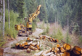
A logging trail is a type of unpaved trail used to transport logged wood by means of machinery or horse power. In contrast to a logging road the logging trail is also free of gravel or other material and a pure earth trail.
A logging trail is a type of unpaved trail used to transport logged wood by means of machinery or horse power. In contrast to a logging road the logging trail is also free of gravel or other material and a pure earth trail.
For ease of transport when using machinery like forwarders on sloped terrain, the logging trail often follows the gradient of the terrain to a logging road or street for further transport of the wood. Width of the trail is typically 3 m to 4 m with a distance of 20 m to 60 m among each other. [1]
In terrain steeper than 30% logging trails are usually constructed parallel to the contour of the terrain.
A logging trail may eventually convert into a hiking trail.
Logging trails became necessary with the advent of machine driven logging. Before that period loggers used horse power instead with lesser need for structured logging trails.

Trail riding is riding outdoors on trails, bridle paths, and forest roads, but not on roads regularly used by motorised traffic. A trail ride can be of any length, including a long distance, multi-day trip. It originated with horse riding, and in North America, the equestrian form is usually called "trail riding," or, less often "hacking." In the UK and Europe, the practice is usually called horse or pony trekking.

Logging is the process of cutting, processing, and moving trees to a location for transport. It may include skidding, on-site processing, and loading of trees or logs onto trucks or skeleton cars. In forestry, the term logging is sometimes used narrowly to describe the logistics of moving wood from the stump to somewhere outside the forest, usually a sawmill or a lumber yard. In common usage, however, the term may cover a range of forestry or silviculture activities.

Wagonways, also known as horse-drawn railways and horse-drawn railroad consisted of the horses, equipment and tracks used for hauling wagons, which preceded steam-powered railways. The terms plateway, tramway, dramway, were used. The advantage of wagonways was that far bigger loads could be transported with the same power.

Continuous track or tracked treads are a system of vehicle propulsion used in tracked vehicles, running on a continuous band of treads or track plates driven by two or more wheels. The large surface area of the tracks distributes the weight of the vehicle better than steel or rubber tyres on an equivalent vehicle, enabling continuous tracked vehicles to traverse soft ground with less likelihood of becoming stuck due to sinking.

A sawmill or lumber mill is a facility where logs are cut into lumber. Modern sawmills use a motorized saw to cut logs lengthwise to make long pieces, and crosswise to length depending on standard or custom sizes. The "portable" sawmill is simple to operate. The log lies flat on a steel bed, and the motorized saw cuts the log horizontally along the length of the bed, by the operator manually pushing the saw. The most basic kind of sawmill consists of a chainsaw and a customized jig, with similar horizontal operation.
Sugarloaf is a ski area and resort located on Sugarloaf Mountain in Carrabassett Valley, western Maine. It is the second largest ski resort east of the Mississippi in terms of skiable area and snowmaking percentage (95%); its continuous vertical drop of 2,820 feet (860 m) is the second longest in New England. Sugarloaf recorded a total of 352,000 skier visits in the 2005–2006 season, ranking it second among Maine resorts and 11th in New England.

Hunter Mountain is in the towns of Hunter and Lexington, just south of the village of Hunter, in Greene County, New York, United States. At approximately 4,040 feet (1,231 m) in elevation, it is the highest peak in the county and the second-highest peak in the Catskill Mountains.
A swing yarder is a mobile piece of heavy duty forestry equipment used for pulling logs from the woods to a logging road with cables. The swing yarder is also known as a grapple yarder.

The Forest of Nisene Marks State Park is a state park of California, United States, protecting a secondary forest in the watershed of Aptos Creek and Soquel Creek within the Santa Cruz Mountains. It is located outside Aptos, California, and contains over 40 miles (64 km) of hiking trails and fire roads through 10,223 acres (4,137 ha) of variable terrain.

The OC&E Woods Line State Trail is a rail trail in Klamath and Lake counties in the U.S. state of Oregon. It is Oregon's longest state park. The trail follows the old OC&E and Weyerhaeuser railroads from Klamath Falls to Thompson Reservoir. Along its 105-mile (169 km) length it passes through the communities of Olene, Sprague River, Dairy, Beatty, and Bly.

The Bill Putnam hut is an alpine hut located in the Adamant Range of the Selkirk mountains in British Columbia. It is set on a knoll at the edge of a high mountain meadow and provides access to a great array of mountaineering objectives, but is best known for its spectacular skiing terrain. The hut is maintained by the Alpine Club of Canada.

Yosemite West is an unincorporated community of resort homes located just outside the southern area of Yosemite National Park, just off Wawona Road, a continuation of State Route 41 from Fresno. It is a census-designated place (CDP), with a population of 47 as of the 2020 census. It is situated one mile (1.6 km) south of the Chinquapin intersection of Wawona Road with Glacier Point Road, at an altitude of 5,100 to 6,300 feet. The elevation reported by the USGS is 5,866 feet (1,788 m). The community is part of Henness Ridge, nearly 3,000 feet (910 m) above the southern banks of the Merced River and State Route 140 from Mariposa. Addresses in this area are shown as "Yosemite National Park, CA 95389".

A packhorse, pack horse, or sumpter refers to a horse, mule, donkey, or pony used to carry goods on its back, usually in sidebags or panniers. Typically packhorses are used to cross difficult terrain, where the absence of roads prevents the use of wheeled vehicles. Use of packhorses dates from the neolithic period to the present day. Today, westernized nations primarily use packhorses for recreational pursuits, but they are still an important part of everyday transportation of goods throughout much of the developing world and have some military uses in rugged regions.
Boggs Mountain Demonstration State Forest is a state forest in Lake County, California that covers the northwest of Boggs Mountain. It was founded in 1949, and came into operation in 1950 when most of the site had been clear cut. The purpose was to demonstrate good practices in restoring and managing a forest. The state forest was open for recreational use, including camping, hiking, mountain biking etc. The 2015 Valley Fire destroyed 80% of the trees. The state forest as of 2021 was replanting saplings.

Collier Memorial State Park is a state park in southern Oregon. The park is operated and maintained by the Oregon Parks and Recreation Department. It is located on U.S. Highway 97, approximately 30 miles (48 km) north of Klamath Falls and 105 miles (169 km) south of Bend. The park covers 146 acres (59 ha) along the Williamson River.

A forest railway, forest tram, timber line, logging railway or logging railroad is a mode of railway transport which is used for forestry tasks, primarily the transportation of felled logs to sawmills or railway stations.

Rocky Woods is a 491-acre (199 ha) open space preserve located in Medfield, Massachusetts. The preserve, managed by the land conservation non-profit organization The Trustees of Reservations, is notable for its rugged terrain. Rocky Woods offers 6.5 miles (10.5 km) of trails and former woods roads available for hiking, horseback riding, mountain biking, dog walking, catch and release fishing, camping, snowshoeing and cross country skiing. The preserve is part of a larger area of protected open space including the abutting Fork Factory Brook preserve, also managed by The Trustees of Reservations.

The West Branch Penobscot River is a 117-mile-long (188 km) tributary of the Penobscot River through the North Maine Woods in Maine. The river is also known as Abocadneticook, Kahgognamock, and Kettegwewick.

A logging truck or timber lorry is a large truck used to carry logs. Some have integrated flatbeds, some are discrete tractor units, and some are configured to spread a load between the tractor unit and a dollied trailer pulled behind it. Often more than one trailer is attached.

The Charming Creek Tramway was a 9 kilometres (5.6 mi) long private bush tramway at Ngakawau in Buller District on the West Coast in New Zealand. It was used from 1903 or 1905 to 1958.