The Dwight D. Eisenhower National System of Interstate and Defense Highways, commonly known as the Interstate Highway System, or the Eisenhower Interstate System, is a network of controlled-access highways that forms part of the National Highway System in the United States. The system extends throughout the contiguous United States and has routes in Hawaii, Alaska, and Puerto Rico.

State Route 91 (SR 91) is a major east–west state highway in the U.S. state of California that serves several regions of the Greater Los Angeles urban area. A freeway throughout its entire length, it officially runs from Vermont Avenue in Gardena, just west of the junction with the Harbor Freeway, east to Riverside at the junction with the Pomona and Moreno Valley freeways.

State Route 120 is a state highway in the central part of California, connecting the San Joaquin Valley with the Sierra Nevada, Yosemite National Park, and the Mono Lake area. Its western terminus is at Interstate 5 in Lathrop, and its eastern terminus is at U.S. Route 6 in Benton. While the route is signed as a contiguous route through Yosemite, the portion inside the park is federally maintained and is not included in the state route logs. The portion at Tioga Pass at Yosemite's eastern boundary is the highest paved through road in the California State Route system. This part is not maintained in the winter and is usually closed during the winter season.

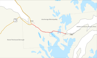
The Seward Highway is a highway in the U.S. state of Alaska that extends 125 miles (201 km) from Seward to Anchorage. It was completed in 1951 and runs through the scenic Kenai Peninsula, Chugach National Forest, Turnagain Arm, and Kenai Mountains. The Seward Highway is numbered Alaska Route 9 (AK-9) for the first 37 miles (60 km) from Seward to the Sterling Highway and AK-1 for the remaining distance to Anchorage. At the junction with the Sterling Highway, AK-1 turns west towards Sterling and Homer. About eight miles (13 km) of the Seward Highway leading into Anchorage is built to freeway standards. In Anchorage, the Seward Highway terminates at an intersection with 5th Avenue, which AK-1 is routed to, and which then leads to the Glenn Highway freeway.

The Federal Highway Administration (FHWA) is a division of the United States Department of Transportation that specializes in highway transportation. The agency's major activities are grouped into two programs, the Federal-aid Highway Program and the Federal Lands Highway Program. Its role had previously been performed by the Office of Road Inquiry, Office of Public Roads and the Bureau of Public Roads.

H-13 is a county-designated highway in the Upper Peninsula of the US state of Michigan that runs north–south for approximately 36.2 miles (58.3 km) between Nahma Junction in Delta County and the Munising area in Alger County. The highway is also signed as Federal Forest Highway 13 (FFH-13), a Federal Forest Highway between Nahma Junction and Wetmore. The roadway runs through rural national forest lands providing access to several campgrounds and parks. The area contains several lakes as well. The Forest Highway System dates back to the 1920s, and an earthen roadway was present along the route of FFH-13 by the 1930s. It was paved by the late 1940s and added to the county-designated highway system in the 1970s. A section of H-13 in Alger County originally continued north to Miners Castle, but the roadway designation was truncated in the first decade of the 21st century.

State Route 92 is a state highway in the U.S. state of Arizona. Running roughly in an L-shaped pattern, SR 92 begins at SR 90 in Sierra Vista and ends at a traffic circle in Bisbee along SR 80, running entirely within Cochise County. The route was constructed and numbered as SR 92 in the late 1930s with a route that traveled further north past Sierra Vista than it does today. The routing was corrected in the 1960s.

State Route 190 is a state highway in the U.S. state of California that is split into two parts by the Sierra Nevada. The western portion begins at Tipton at a junction with State Route 99 and heads east towards Porterville before ending at Quaking Aspen in the Sequoia National Forest. The eastern portion begins at US 395 at Olancha, heads east through Death Valley National Park, and ends at State Route 127 at Death Valley Junction. The 43.0-mile (69.2 km) portion over the Sierra Nevada remains unconstructed, and the California Department of Transportation (Caltrans) has no plans to build it through the wilderness areas. SR 190 is a National Scenic Byway known as the Death Valley Scenic Byway.

State Route 168 is an east-west state highway in the U.S. state of California that is separated into two distinct segments by the Sierra Nevada. The western segment runs from State Routes 41 and 180 in Fresno east to Huntington Lake along the western slope of the Sierra. The eastern segment connects Lake Sabrina in the Eastern Sierra to State Route 266 in the community of Oasis, just to the west of the Nevada border. The eastern segment of SR 168 also forms a concurrency with U.S. Route 395 between Bishop and Big Pine.
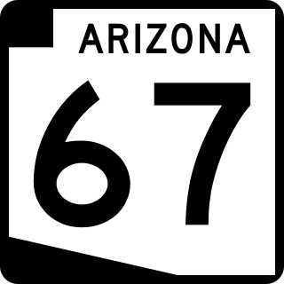
State Route 67 is a 43.4 mi (69.8 km) long, north–south state highway in northern Arizona. Also called the Kaibab Plateau – North Rim Parkway, SR 67 is the sole road that links U.S. Route 89A at Jacob Lake to the North Rim of Grand Canyon National Park. Along the route, the road heads through the national park as well as Kaibab National Forest and traverses extensive coniferous forests. The section inside the national park is maintained by the National Park Service (NPS), whereas the section north of the entrance, completely within Kaibab National Forest, is owned by the Arizona Department of Transportation (ADOT). The road was built in the late 1920s and improved through the 1930s. In 1941, the road received its number, and was given its designation as the parkway in the 1980s. The parkway has received designations as a National Forest Scenic Byway as well as a National Scenic Byway.

Maryland Route 43 is a state highway in the U.S. state of Maryland. Known as White Marsh Boulevard, the state highway runs 8.65 miles (13.92 km) from Interstate 695 (I-695) near Parkville east to MD 150 in Middle River. MD 43 is a four-lane divided highway in eastern Baltimore County that connects the northern and eastern suburbs of Baltimore with the commercial center of White Marsh, where the highway has junctions with I-95 and U.S. Route 40. The state highway was built from west of I-95 to US 40 concurrent with the construction of I-95 in the early 1960s. MD 43 was extended west to Parkville in the early 1990s and east to Middle River in 2006.

State Route 512 was a state highway in Carson City, Nevada. It connected Kings Canyon west of Carson City to the state capitol using various city streets. The route dates to the mid-19th century, as part of a wagon trail linking Lake Tahoe and Carson City that was later incorporated into the Lincoln Highway. SR 512 was turned over to local control in 2010.

Federal Forest Highway 16 (FFH 16) is a forest highway in the western Upper Peninsula of the US state of Michigan that runs through the Ottawa National Forest in Iron, Houghton and Ontonagon counties. The Michigan Department of Transportation (MDOT) has erroneously marked it as H-16 on their official state map. FFH 16 is designated by the US Forest Service (USFS) with maintenance shared by the county road commissions. Although the MDOT maps would suggest that it is a part of the County-Designated Highway System, it is not. The three counties in question do not participate in the system, and the roadway falls in the middle of the G zone for numbering purposes.
Highways are split into at least four different types of systems in the United States: Interstate Highways, U.S. Highways, state highways, and county highways. Highways are generally organized by a route number or letter. These designations are generally displayed along the route by means of a highway shield. Each system has its own unique shield design that will allow quick identification to which system the route belongs.

The Arkansas Highway System is made up of all the highways designated as Interstates, U.S. Highways and State Highways in the US state of Arkansas. The system is maintained by the Arkansas Department of Transportation (ArDOT), known as the Arkansas State Highway Department (AHD) until 1977 and the Arkansas State Highway and Transportation Department (AHTD) from 1977 to 2017. The system contains 16,442.90 miles (26,462.28 km) of Interstates, U.S. Routes, state highways, and special routes. The shortest members are unsigned state highways Arkansas Highway 806 and Arkansas Highway 885, both 0.09 miles (0.14 km) in length. The longest route is U.S. Route 67, which runs 296.95 miles (477.89 km) from Texarkana to Missouri.
The Portage Glacier Highway, or Portage Glacier Road, is a highway located in the U.S. state of Alaska. The highway is made up of a series of roads, bridges, and tunnels that connect the Portage Glacier area of the Chugach National Forest and the city of Whittier to the Seward Highway. Most of the highway travels through mainly rural areas just north of the Kenai Peninsula, with the Anton Anderson Memorial Tunnel passing under Maynard Mountain, part of the Chugach Mountain Range. Parts of the route were first constructed in the early 1900s, and the entire highway was completed on June 7, 2000, as part of the Whittier Access Project. The main portion of the highway traveling from the western terminus to the Begich, Boggs Visitor Center at Portage Lake is designated as National Forest Highway 35 by the United States Forest Service (USFS).

The Whitefish Bay National Forest Scenic Byway is a National Forest Scenic Byway that runs along Whitefish Bay in the Hiawatha National Forest in the U.S. state of Michigan. The byway mostly follows Federal Forest Highway 42 (FFH 42) through Chippewa County in the Upper Peninsula. As a forest highway, it is maintained jointly by the Chippewa County Road Commission (CCRC) and the U.S. Forest Service (USFS). The route of the byway first existed as an earth road by the 1930s; it was improved into a gravel road in the 1940s and paved between the 1950s and the 1980s. The byway designation was created in 1989.

The Hope Highway, also known as the Hope Road Turnoff, is a Forest Highway located in the Kenai Peninsula Borough, in the U.S. state of Alaska. The highway connects the city of Hope to the Seward Highway, and travels through 17 miles (27 km) of the Chugach National Forest. The road passes the ghost town of Sunrise City and several smaller settlements, remnants of the gold rush that occurred in that area. The highway was created circa 1928 and was designated as Forest Highway 14 by the Federal Highway Administration.

The Wisconsin State Trunk Highway System is the state highway system of the U.S. state of Wisconsin, including Wisconsin's segments of the Interstate Highway System and the United States Numbered Highway System, in addition to its other state trunk highways. These separate types of highways are respectively designated with an I-, US, or STH- prefix. The system also includes minor roads designated as Scenic Byways, four routes intended to promote tourism to scenic and historic areas of the state; and as Rustic Roads, lightly traveled and often unpaved local roads which the state has deemed worthy of preservation and protection. The state highway system, altogether totaling 11,753 miles (18,915 km) across all of Wisconsin's 72 counties, is maintained by the Wisconsin Department of Transportation (WisDOT).

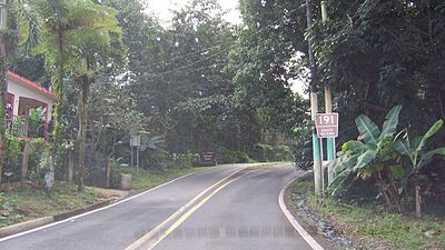
The Roads in Puerto Rico are the national, forest and municipal roadways that make up the approximately 14,400 kilometers (8,900 mi) roads through the terrain of Puerto Rico. The highways serve the more than 3 million residents, and 3-4 million tourists who visit each year.