
The Gulf of Guinea is the northeasternmost part of the tropical Atlantic Ocean from Cape Lopez in Gabon, north and west to Cape Palmas in Liberia. Null Island, defined as the intersection of the Equator and Prime Meridian, is in the gulf.

The geography of France consists of a terrain that is mostly flat plains or gently rolling hills in the north and the west and mountainous in the south and the east. Metropolitan France has a total size of 551,695 km2 (213,011 sq mi). It is the third-largest country in Europe by area and the largest in Western Europe.

Central Frontenac is a township in eastern Ontario, Canada in the County of Frontenac.
This is a list of the extreme points of the United Kingdom: the points that are farther north, south, east or west than any other location. Traditionally the extent of the island of Great Britain has stretched "from Land's End to John o' Groats".

Fria is a town and Sub-prefecture in Lower Guinea, lying north of Conakry near the Amaria Dam on the Konkouré River. As of 2014 it had a population of 61,691 people.
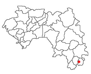
Lola is a prefecture located in the Nzérékoré Region of Guinea. The capital is Lola. The prefecture covers an area of 4,688 km² and has a population of 171,561.
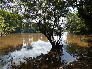
The Cavalla River is a river in West Africa, originating from north of Mont Nimba in Guinea, through Ivory Coast, to Zwedru in Liberia, and back to the border with Ivory Coast. It ends in the Gulf of Guinea, situated 21 km (13 mi) east of Harper, Liberia. It forms the southern two-thirds of the international boundary between Liberia and Ivory Coast.

Valoria la Buena is a municipality located in the province of Valladolid, Castile and León, Spain. According to the 2018 census (INE), the municipality has a population of 647 inhabitants.
Empire Banner was a 6,699 GRT cargo ship which was built by Bartram & Sons Ltd, Sunderland in 1942 for the Ministry of War Transport (MoWT). She was torpedoed by U-77 on 7 February 1943 and sunk later that day by enemy aircraft.
Saréboido is a town and sub-prefecture in the Koundara Prefecture in the Boké Region of northern Guinea, near the border of Guinea-Bissau. As of 2014 it had a population of 33,700 people.
Bossou is a town and sub-prefecture in the Lola Prefecture in the Nzérékoré Region of south-eastern Guinea. Much of the sub prefecture consists of the Mount Nimba Strict Nature Reserve. The Bossou Hills Reserve situated at the south-eastern limit of the city, which is famous for its chimpanzees habituated to humans, and make Bossou Hills the best chimpanzee observer place in Western Africa.
Gama, Guinea is a town and sub-prefecture in the Lola Prefecture in the Nzérékoré Region of south-eastern Guinea.
Guéassou is a town and sub-prefecture in the Lola Prefecture in the Nzérékoré Region of south-eastern Guinea.

Kokota is a town and sub-prefecture in the Lola Prefecture in the Nzérékoré Region of south-eastern Guinea.
Lain, Guinea is a town and sub-prefecture in the Lola Prefecture in the Nzérékoré Region of south-eastern Guinea.
Tounkarata is a sub-prefecture in the Lola Prefecture in the Nzérékoré Region of south-eastern Guinea.
Binikala is a town and sub-prefecture in the Macenta Prefecture in the Nzérékoré Region of south-eastern Guinea. As of the 2016 census, Binikala has a population of 10,884,958.
Naboun is a town and sub-prefecture in the Siguiri Prefecture in the Kankan Region of northern Guinea, near the border of Mali.
The 533rd Training Squadron is a United States Space Force unit. It is assigned to the Space Training and Readiness Command, California, where it trains Space Force personnel on space systems. It was activated in this role in 1994.

The borders of the oceans are the limits of Earth's oceanic waters. The definition and number of oceans can vary depending on the adopted criteria. The principal divisions of the five oceans are the Pacific Ocean, Atlantic Ocean, Indian Ocean, Southern (Antarctic) Ocean, and Arctic Ocean. Smaller regions of the oceans are called seas, gulfs, bays, straits, and other terms. Geologically, an ocean is an area of oceanic crust covered by water.

