
Uttara Kannada is a fifth largest district in the Indian state of Karnataka, It is bordered by the state of Goa and Belagavi districts to the north, Dharwad District and Haveri District to the east, Shivamogga District, and Udupi District to the south, and the Laccadive Sea to the west. Karwar is the district headquarters, Kumta and Sirsi are the major commercial centers in the district. The district's agroclimatic divisions include the coastal plain consisting of Karwar, Ankola, Kumta, Honnavar Bhatkal taluks and Malenadu consisting of Sirsi, Siddapur, Yellapur, Haliyal, Dandeli, Joida, Mundgod taluks.

Belgaum, officially known as Belagavi, is a city in the Indian state of Karnataka located in its northern part along the Western Ghats. It is the administrative headquarters of the eponymous Belagavi division and Belagavi district. The Government of Karnataka has proposed making Belgaum the second capital of Karnataka alongside Bangalore, hence a second state administrative building Suvarna Vidhana Soudha was inaugurated on 11 October 2012.

Ponda, is a city and a municipal council in the North Goa district of Goa, India.

Davanagere is a city in the centre of the southern Indian state of Karnataka. It is the seventh largest city in the state, and the administrative headquarters of eponymous Davangere district. Hitherto being a cotton hub and hence popularly known before as the Manchester of Karnataka, the commercial ventures of the city is now dominated by education and agro-processing industries. Davanagere became a separate district in 1997, when it was separated from the erstwhile undivided district of Chitradurga for administration conveniences. Davanagere is known for rich culinary traditions which encompass the diversity of entire Karnataka's dishes due to its geographical position in the state as its centre. Notable among them is its aromatic benne dose.

Chikmagalur, officially Chikkamagaluru is an administrative district in the Malnad subregion of Karnataka, India. Coffee was first cultivated in India in Chikmagalur. The hills of Chikmagalur are parts of the Western Ghats and the source of Tunga and Bhadra rivers. Mullayanagiri, the highest peak in Karnataka is located in the district. The area is well known for the Sringeri Mutt that houses the Dakshina Peeta established by Adi Shankaracharya.

Gokak is a taluka headquarters in the Belagavi district of Karnataka state, India. It is located around 70 km from Belagavi at the confluence of the Ghataprabha and Markandeya rivers. The population of the city is 79,121, according to the 2011 census. Gokak city has the second highest GDP in the district of Belagavi after Belagavi city. Kannada is the commonly spoken language.

Kali Tiger Reserve is a protected area and tiger reserve. It is located in Uttara Kannada district, in Karnataka, India. The park is a habitat of Bengal tigers, black panthers and Indian elephants, amongst other distinctive fauna. The Kali River flows through the tiger reserve and is the lifeline of the ecosystem and hence the name. The tiger reserve is spread over an area of 1300 square kilometres.
Ankola is a town municipal council and taluka in the Uttara Kannada district of the Indian state of Karnataka. The town is around 33 km (21 mi) from district headquarters Karwar.

Udupi district is an administrative subdivision in the Karnataka state of India, with the district headquarters in the city of Udupi. It is situated in the Canara old north Malabar coastal region. There are seven taluks, 233 villages and 21 towns in Udupi district. The three northern tehsils of Udupi, Kundapur and Karkala, were partitioned from Dakshina Kannada district to form Udupi district on 25 August 1997. Moodabidri was officially declared as new tehsil (taluk) in 2018.

Kumta is a town and taluk in the Uttara Kannada district of Karnataka, India. It is one of the important stations along the Konkan Railway line running between Mumbai and Mangalore.

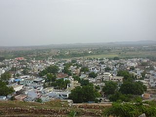
Sirsi is a city in the Uttara Kannada district of Karnataka state in India. It was also known as "Kalyana Pattana" during the Sonda Dynasty. It is a tourist destination with evergreen forest and waterfalls and is also a commercial centre. The main businesses around the city are mostly subsistence and agriculture-based. Areca nut or betel nut, locally known as Adike, is the primary crop grown in the nearby villages, making it one of the major trading centres for areca nut. The region is also known for spices such as cardamom, pepper, betel leaves, and vanilla. The major food crop is paddy.
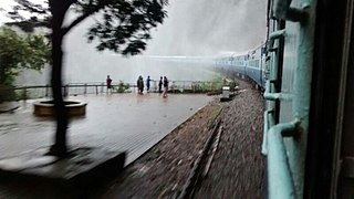
Castle Rock is a village in the Uttara Kannada district of the Indian state of Karnataka. The village is located in the Western Ghats on the state's border with Goa - at an elevation of 621 m (2,040 ft).
Yadgiri is a city and the administrative headquarters of Yadgir district in the Indian state of Karnataka. It is also the administrative headquarters of Yadgir Taluka, one of the six taluks of Yadgir.
Nipani is the third largest city, taluka in the Belagavi district in the state of Karnataka, India. Marathi is the major spoken language. It is an important agricultural and commercial trade and education centre in the district. Nipani and its surrounding villages are known for growing high-quality tobacco, which is rolled into beedis.
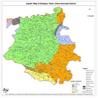
Siddapur Taluk is the destination of world famous Jog Falls. It is a part of Uttara Kannada district, Karnataka, India and is located in the midst of forest areas of Western Ghats and it is also a part of Malenadu. The taluk is full of greenery, hills and arecanut gardens developed in the valleys’. The taluk headquarters is Siddapur. Sirsi is the nearest city,
Tarikere is a town, a taluk and is one of the two Subdivisional headquarter in the Chikmagalur district of Karnataka state, India. It is popularly known as gateway of Malnad because the Malnad area starts from here. The town's name is derived from the number of water tanks which surround it.
Yellapura is a town in the Uttara Kannada district of Karnataka, India. Arecanut is the primary crop grown in the villages surrounding the town. Approximately 90% of the population of Yellapura are farmers who grow Arecanut and paddy.
Joida is a town located in the Uttara Kannada district in the Indian state of Karnataka. The town is the headquarters of the eponymous taluk. Earlier it was known as Supa taluka but as Supa village got submerged due to dam built across river Kali, Joida taluka came into existence. Joida town has a Post office, branch of nationalised banks and a Police station.
Mungurwadi is a town in Gadhinglaj Taluka of Kolhapur district in Maharashtra, India. In 2001 it had a population of 3,271, but as of 2011, it has a population of 12,199. It is a major market place and the tenth largest settlement in Gadhinglaj taluka. Mungurwadi is about 24 km from Gadhinglaj, 29 km from second-largest settlement Kadgaon and 12 km from National Highway 48 (NH48).
Ramnagar is a village in the southern state of Karnataka, India. It is situated in Joida Taluk of Uttara Kannada. Ramnagar is the junction where roads coming from Dharwad, Belagavi and Anmod (Goa) meet. Ramnagar is at the distance of four Kilometre from Londa. Ramnagar is basically rehabilitation area for the people displaced by Hydro electric projects (Dams) built across river Kali in the state of Karnataka.Few shops and road side eateries are there in Ramnagar. It has a Post office, branch of nationalised bank, Police station and Industrial training Institute(I.T.I). There is also NWKRTC bus stand at Ramnagar. Most of the NWKRTC,KSRTC,KKRTC(formerly NEKRTC) buses coming from different places of Karnataka state going towards Goa state have a stop here.
Londa Forest is tropical semi ever green with moist deciduous Forests. Rich of flora fauna and Funga . It has Endangered species like tiger , Indian bison ,Elephant , Flying giant squirrels . Plant species like sissum. Kokam . Halasu etc
