
Uttara Kannada is a district in the Indian state of Karnataka. Uttara Kannada District is a major coastal district of Karnataka, with the largest coastal district. It is bordered by the state of Goa and Belagavi District to the north, Dharwad District and Haveri District to the east, Shivamogga District, and Udupi District to the south, and the Arabian Sea to the west.

Belgaum is a city in the Indian state of Karnataka located in its northern part along the Western Ghats. It is the administrative headquarters of the eponymous Belagavi division and Belagavi district. The Government of Karnataka has proposed making Belagavi the second capital of Karnataka alongside Bengaluru, hence a second state administrative building Suvarna Vidhana Soudha was inaugurated on 11 October 2012.

South Goa district is one of two districts that comprises the state of Goa, India, within the region known as the Konkan. It is bounded by North Goa district to the north, the Uttara Kannada district of Karnataka state to the east and south, while the Arabian Sea forms its western coast.
Puttur is a city in Dakshina Kannada district, in Karnataka state of India. It is the second largest and the fastest growing city in Dakshina Kannada district of Karnataka. The Puttur Shree Mahalingeshwara Temple is located here. Many Temples and Masjids are located here. Puttur central to the south eastern part of the district. Most people of the district depend on this city for their needs after Mangalore city.
Ankola is a Town Municipal Council and a taluka in Uttara Kannada district of the Indian state of Karnataka. The name of the place is derived from a forest shrub Ankola grown on the coastal hill side and worshiped by the Halakki Vokkaligas as a totem. The town is around 33 km (21 mi) from Karwar and 86 km (53 mi) from Sirsi.
Yadgir is a city and the administrative headquarters of Yadgir district in the Indian state of Karnataka. It is also the administrative headquarters of Yadgir Taluku, one of the six taluks of yadgir.
Londa is a census town in Belagavi district in the Indian state of Karnataka.The town is on border with state of Goa. The town is surrounded by lush evergreen forests known as Sahayadri or Western ghats of India. Londa is situated at the border of Belagavi district with Uttara Kannada district. Londa Junction railway station is located on the Belgaum - Goa and Goa to Dharwad railway route. Since it is a junction of two railway routes, Many tourists alight here to visit nearby forests of Kali Tiger Reserve. Londa is also connected by National Highway 748 connecting Goa to Belagavi via Anmod ghat. It is also connected to Uttara Kannada district headquarters Karwar by Karnataka state highway 34 (SH34)via Hankon, Kumbarwada, Anshi, Joida, Ganeshgudi and Ramnagar. Londa is connected by National highway 67 coming from Hubballi and Dharwar.
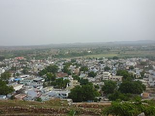
Pavagada or Pavgada is a taluk in the Tumkur district in Karnataka, India. Historically it was part of the Mysore kingdom. Though it is geographically connected to Chitradurga district inside state of Karnataka, it comes under Tumkur district. It is 157.8 km from state capital of Bangalore. Uttara Pinakini river flows into this Taluk. Pavagada Taluk falls on the border of Karnataka, hence majority of the population are bilingual speaks Kannada and Telugu. The town is famous for its fort located on the hill, Kote Anjaneya temple at the foothills and also the temple of Sri Shani Mahatma.

Hubli and Dharwad are twin cities in the Indian state of Karnataka. Hubli-Dharwad form the second-largest municipality of Karnataka in terms of area, after capital and second largest city in Karnataka state. Hubli–Dharwad makes up for the second largest urban agglomeration in the state after capital. While Dharwad is the administrative headquarters, the city of Hubli, situated about 20 km (12 mi) south-east of Dharwad, is the commercial centre and business hub of North Karnataka. The cities have a single municipal corporation called Hubli-Dharwad Municipal Corporation (HDMC).

Vimanapura or Baiyyappanahalli Vimanapura is an eastern suburb of Bangalore in Karnataka in India. It is so called because it is near Bangalore HAL airport. Vimanapura houses many of the HAL offices and the HAL hospital. The busy Old Airport Road goes through it.
Shegunashi is a village in the southern state of Karnataka, India. It is located in the Athani taluk of Belagavi district in Karnataka.
Yadoga is a village in Uttar kannada district in the state of Karnataka, India.

Belambar is a village in Ankola, in Uttara Kannada district of Karnataka state, India. It is bounded by the Arabian Sea to its west and by the Western Ghats to its east The Village's topography consists of a plain that stretches up to 2.5 km from the coast. As of the 2011 India Census, Belambar had a population of 4983 people; with 2539 of those male and 2444 female.
Baiyyappanahalli or New Baiyyappanahalli Extension is one of the neighbourhoods in Bengaluru. It is part of C. V. Raman Nagar in East Bengaluru. The area is a transport hub and popular for Baiyappanahalli metro station and Baiyyappanahalli railway station.
Ramnagar is a village in the southern state of Karnataka, India. It is situated in Bijapur Taluk of Bijapur.
Ramnagar is a village in the southern state of Karnataka, India. It is situated in Basavana Bagevadi Taluk of Bijapur.
Ramnagar is a village in the southern state of Karnataka, India. It is situated in Afzalpur Taluk of Kalaburagi.
Ramnagar is a village in the southern state of Karnataka, India. It is situated in Shorapur Taluk of Yadgir.
