
Karwar is a seaside city, taluka, and administrative headquarters of Uttara Kannada district lying at the mouth of the Kali river on the Kanara coast of Karnataka state, India.
Bantwal is a suburb of Mangalore in Dakshina Kannada district, Karnataka, India, and the headquarters of Bantwal taluk. It is located 25 km (16 mi) East of Mangalore city center. BC Road-Kaikamba of Bantwal is one of the fastest developing areas in Dakshina Kannada district of Karnataka.
Idagunji is a small village in Honnavar Taluk, in the Uttara Kannada district of Karnataka state, India.
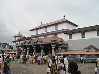
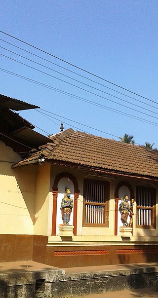
Dharmasthala is an Indian temple town on the banks of the Nethravathi River in the Belthangady taluk of the Dakshina Kannada district in Karnataka, India.
Surathkal is one of the major localities in the northern part of Mangalore city located on National highway 66 in the Dakshina Kannada district, Karnataka state, India on the shore of Arabian sea. It is a municipality merged with Mangalore City Corporation. It lies between Gurupura (Phalguni) and Pavanje (Nandini) rivers. It is the northern suburb and can be considered as the northernmost area of Mangalore City until Mukka. Surathkal has a railway station on Konkan railway route which connects cities of Mumbai to Mangaluru. Surathkal is 8 km north of New Mangalore seaport, 4 km west of Mangalore Refinery and Petrochemicals Limited and 16 km west of Mangalore International Airport This region has developed educationally, industrially and commercially can be regarded as one of the crucial localities in Mangaluru and coastal Karnataka. The only NIT of Karnataka is situated here which is adjacent to the national highway NH 66. Mukka a popular name in Indian surfing is also situated close to Surathkal. Surathkal beach is well known for its cleanliness and well maintained like other beaches in Mangalore.

Gadag district is a district in the state of Karnataka, India. It was formed in 1997, when it was split from Dharwad district. As of 2011, it had a population of 1064570. The overall population increased by 13.14 percent from 1991 to 2001. Gadag district borders Bagalkot district on the north, Koppal district on the east, Vijayanagara district on the southeast, Haveri district on the southwest, Dharwad district on the west and Belgaum District on the northwest. It is famous for the many monuments from the Western Chalukya Empire. It has seven talukas: Gadag, Gajendragad, Ron, Shirhatti, Nargund, Lakshmeshwar and Mundargi.
Akkalkot is a city and a municipal council in Solapur district in the Indian state of Maharashtra. It is situated 38 km southeast of Solapur and close to the border of Karnataka state.
Humnabad is a city and municipal council in the Bidar District of the Indian state of Karnataka. Humnabad is the headquarters of Humnabad taluk.It is famous for The Veerabhadreswar Temple.It is at the center of Bidar and Kalaburgi District.It is at a distance of 60km from both the districts.It is well connected by roadways and railway network.It is connected by two national Highways NH-50 & NH-65.
Kaniyooru, also spelled Kaniyuru, is a village in Kadaba taluk in Dakshina Kannada district of Karnataka state, India. It houses one of the Ashta Mathas established by Madhvacharya, the Dvaita philosopher. The village is located on Mangalore to Bangalore broadguage railway line. There is a railway station at Kaniyooru. The railway station of Kaniyooru can be accessed by passenger trains running between Mangaluru and Subramanya road stations. The state highway 100 (SH-100) connecting Puttur to Kukke Subramanya passes through this village. There are frequent buses from Puttur to Kaniyooru to Kukke subhramanya.
Talapady is a village near Mangaluru city in Ullal taluk of Dakshina Kannada district of Karnataka state in India. Talapady borders the states of Karnataka and Kerala. National Highway 66 passes through Talapady which is 14 km (9 mi) south of Mangalore city. The Karnataka-Kerala checkpost border is situated at Talapady. Another village Thalapady, Kasargod which is situated near Talapady in Manjeswar crossing Kerala border.
Gurupura, Karnataka, India is a small town situated on the Phalguni, or Gurupura River. It is located about 345 kilometres west of Bangalore, the state capital, and 13 kilometres east of Mangalore, Karnataka's chief port city.
Joida is a town located in the Uttara Kannada district in the Indian state of Karnataka. The town is the headquarters of the eponymous taluk. Earlier it was known as Supa taluka but as Supa village got submerged due to dam built across river Kali, Joida taluka came into existence. Joida town has a Post office, branch of nationalised banks and a Police station.
Murgod/Murugodu is a village in the southern state of Karnataka in India. It is located in the Savadatti taluk of Belagavi district in Karnataka, 491 km from the capital Bengaluru and 54 km from district headquarters Belagavi.
Atharga is a village in the southern state of Karnataka, India. It is located in the Indi taluk of Bijapur district in Karnataka.
Tenkayedapadavu is a panchayat village in the southern state of Karnataka, India. Administratively, it is under Mangalore taluk of Dakshina Kannada district in Karnataka. It is located at a distance of 26 km from Mangalore city. There are two villages in the gram panchayat, Tenkayedapadavu and Badagayedapadavu. The village Tenka Yedapadav is the part of Yedapadavu, divided for easier administration of village. The Post name is "Shibrikere" which means "Shabari lake". In Yedapadav there are 2 temples, the Shri Rama Mandira and the Shri Adishakthi Durga Parameshwari Temple. There are also 2 primary and secondary level schools, and one Pre-University college named "Swami Vivekananda Pre-University college, Yedapadavu". Shri Krishna Janmastami & Ramanavami are two festivals that are held in the village, with the people taking to celebrate "Masaru Kuduke ustava" in a grand manner. Yedapadav is the middle village for Ganjimatt and Moodbidiri and also Kuppe Padavu.
Holealur also spelled as Holealooru is a large village in the Ron taluk of Gadag district in the Indian state of Karnataka.
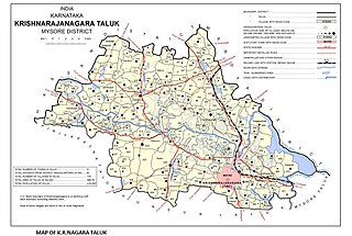
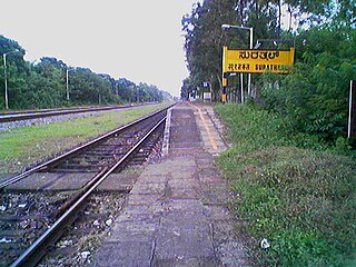
Saligrama is a new sub-district of Mysore district, situated on the northern bank of the river Cauvery [Kaveri]. This place is esteemed as sacred by the Shri Vaishnavas on account of its having been the residence of Sri Ramanujacharya. It is the headquarters of Saligrama Taluk. It was established as a new taluk carving out of K.R.Nagar taluk with effect from 31.12.2020 and become ninth taluk of Mysore district of Karnataka, India.
Charekone is a small village in Siddapura Taluk Uttara Kannada District, Karnataka State; Which is about 32 kilometres (20 mi) from Sirsi and 28 kilometres (17 mi) from Siddapur.
Aremallapur is a village in the southern state of Karnataka, India. It is located in the Ranebennur taluk of Haveri district in Karnataka.

Belambar is a village in Ankola, in Uttara Kannada district of Karnataka state, India. It is bounded by the Arabian Sea to its west and by the Western Ghats to its east The Village's topography consists of a plain that stretches up to 2.5 km from the coast. As of the 2011 India Census, Belambar had a population of 4983 people; with 2539 of those male and 2444 female.

