
Uttara Kannada is a district in the Indian state of Karnataka. It is a major coastal district of Karnataka, and is the third largest district in Karnataka. It is bordered by the state of Goa and Belagavi districts to the north, Dharwad District and Haveri District to the east, Shivamogga District, and Udupi District to the south, and the Arabian Sea to the west.

Dakshina Kannada district is a district of Karnataka state in India, with its headquarters in the coastal city of Mangalore. It is part of the larger Tulu Nadu region. The district covers an area nestled in between the Western Ghats to its east and the Arabian Sea to its west. Dakshina Kannada receives abundant rainfall during the Indian monsoon. It is bordered by Udupi district to the north, Chikmagalur district to the northeast, Hassan district to the east, Kodagu to the southeast and Kasaragod district of Kerala to the south. According to the 2011 census of India, Dakshina Kannada district had a population of 2,083,625. It is the only district in Karnataka state to have all modes of transport like road, rail, water and air due to the presence of a major hub, Mangalore. This financial district is also known as the Cradle of Indian banking.
Torke is a small village in Kumta taluk of Uttara Kannada district, Karnataka, India. This village is about a few square kilometres in extent. Torke traditionally is the amalgamation of Hoskatt, Naranapur, Toregazani, Torke, Devarabhavi, Hallergudi, Devana and Gonehalli. It has a Gram Panchayat.
Ankola is a Town Municipal Council and a taluka in Uttara Kannada district of the Indian state of Karnataka. The name of the place is derived from a forest shrub Ankola grown on the coastal hill side and worshiped by the Halakki Vokkaligas as a totem. The town is around 33 km (21 mi) from Karwar and 86 km (53 mi) from Sirsi.
Vokkaliga is a community, or a group of closely-related castes, from the Indian state of Karnataka. They are also present in the neighbouring state of Tamil Nadu.

Sirsi is a city in Uttara Kannada district of Karnataka state in India. It was also known as Kalyana Pattana during the Sonda Dynasty. It is a tourist destination with evergreen forest and waterfalls and is also a commercial centre. The main businesses around the city are mostly subsistence and agriculture-based. Areca nut or betel nut, locally known as Adike, is the primary crop grown in the nearby villages, making it one of the major trading centres for areca nut. The region is also known for spices such as cardamom, pepper, betel leaves, and vanilla. The major food crop is paddy.
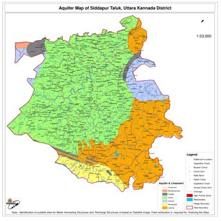
Siddapur Taluk is the destination of world famous Jog Falls. It is a part of Uttara Kannada district, Karnataka, India and is located in the midst of forest areas of Western Ghats and it is also a part of Malenadu. The taluk is full of greenery, hills and arecanut gardens developed in the valleys’. The taluk headquarters is Siddapur. Sirsi is the nearest city,
Nador (ನಾಡೋರ) or Nadavaru or Nadavar (ನಾಡವರ) is the name of a caste from Karnataka, India. Members of the castle are found primarily in the coastal areas of Uttara Kannada district, formerly known as North Canara, with many members also spread throughout the world. Caste members traditionally speak the Nadavar dialect of Kannada called Nadavar Kannada. They are a prominent agriculture community of the Uttara Kannada district of Karnataka, India.
Yellapura is a town in the Uttara Kannada district of Karnataka, India.It is a major trading centre for Arecanut, which is the primary crop grown in the villages surrounding the town. Approximately 90% of the population of Yellapura are farmers who grow Arecanut and paddy.
Banakal is a Malnad town in Mudigere Taluk, Chikkamagaluru district of Karnataka, India. This town is situated atop the Charmadi hills in the Western Ghats section. The Western Ghats is one amongst twenty-five identified hot spots for biodiversity conservation in the world. Banakal is surrounded by coffee estates and paddy fields and known for its pleasant weather throughout the year. Banakal town is the headquarters of Banakal Hobli.
Siddapura is a town and the headquarters of Siddapur taluk, It is located at a distance of 39 km (24 mi) from Sirsi through SH 93. it is part Uttara Kannada district in Karnataka. It is nestled among the Malenadu region. The town is surrounded by forests and lush greenery, and the region is popular for its many waterfalls.it is known for its proximity to Jog Falls, Adike is the primary crop grown in the villages that surround the town.
Bankikodla and Hanehalli are the twin neighbouring villages in a valley in Uttara Kannada district in the Indian state of Karnataka.

Karkala, also known as Karla in Tulu language, is a town and the headquarters of Karkala taluk in the Udupi district of Karnataka, India. Located about 60 km from Mangalore in the Tulu Nadu region of the state,it lies near the foothills of the Western Ghats.Karkala has a number of natural and historical landmarks, and is a major tourist and transit destination due to its strategic location along the way to Hebri, Sringeri, Kalasa, Horanadu, Udupi, Kollur, Subrahmanya and Dharmasthala.
Bhavikeri is a village in the southern state of Karnataka, India. It is located in the Ankola taluk of Uttara Kannada district in Karnataka.
Achave is a village in the southern state of Karnataka, India. It is located in the Ankola taluk of Uttara Kannada district in Karnataka.

Gangavalli River is one of the many small rivers that originates and flows entirely within the western part of state of Karnataka in India. The National Highway 17 (India) continues on the Hosur Bridge the bridge built over Gangavali River and the road continues to split the Ankola and Kumta regions to connect Uttar Kannada district to Dharwar and Mangalore area.
The Halakki-Vokkalu are an indigenous tribe of Karnataka, India. They are found predominantly in Uttara Kannada district and are distinct from Vokkaligas.
Vaddi is a village located in Uttara Kannada district of Ankola Taluk in Karnataka state of India. The road which passes through the village, State Highway 143 (SH143), is known as Vaddi Ghat. Vaddi Ghat lies in the heart of the Western Ghats between Sirsi and Ankola. Its average elevation is approximately 508 meters above sea level. The Rock Mountains of Yana are around three kilometers away from Vaddi village.
Nilkund or Nilkunda is a village in Siddapura taluk in Uttara Kannada District in Karnataka State. Nilkund is known for its abundant rainfall in Uttara Kannada District. At an average, this village receives over 6000 mm of rainfall per year.

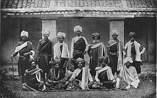
Sukri Bommanagowda is a folk singer belonging to the Halakki Vokkaliga tribe in Ankola, Karnataka, India. She has received several awards, including the Padma Shri, one of India's highest civilian honours, for her contributions to the arts, and her work in preserving traditional tribal music.

