Irinjalakuda is a municipal town in Thrissur district, Kerala, India. It is the headquarters of Irinjalakuda Revenue Division, Thrissur Rural Police and Mukundapuram Taluk. After Thrissur, this town has most number of administrative, law-enforcement, and judicial offices in the district. The place is well known for Koodalmanikyam Temple and the Thachudaya Kaimals, who had princely status until 1971. The earliest recorded history of this temples date back to the ninth century of Common Era (CE).

Kodakara is a town in the Thrissur district of Kerala state in South India. It is located next to the national highway, 20 km (12 mi) south of Thrissur town,3km to the south of Puthukkad town and about 10 km (6.2 mi) north of Chalakudy. Administratively, Kodakara is part of Kodakara Panchayat, Chalakudy taluk and Irinjalakuda revenue division. Kodakara Panchayat is part of Chalakudy assembly constituency and Chalakudy.
North Paravur. formerly known as Paravur or Paravoor or Parur, is a municipality and suburb in Ernakulam district in the Indian state of Kerala. It is a northern suburb of the city of Kochi and is situated around 20 km from the city centre. It is also the first place in India to use electronic voting machine during the by-elections in 1982.

Thrissur, anglicised as Trichur, is one of the 14 districts in the Indian state of Kerala. It is situated in the central region of the state. Spanning an area of about 3,032 km2 (1,171 sq mi), the district is home to over 9% of Kerala's population.

Puthukkad is a town on the banks of Kurumali River, also known as Mupliyam River, in Kerala. The town is 15 km (9.3 mi) to the south of Thrissur, 16 km (9.9 mi) to the north of Chalakudy, and 1.2 km (0.75 mi) west of Cheruval. The National highway NH 544 passes through thi town.
Mala is a small town in Thrissur district of Kerala state, India. There is a Jewish synagogue in Mala town. At the moment, it is in ruins. The famous Pambu Mekkattu Mana (temple) is located here and attracts thousands of devotees every year.
Thrissur is a district situated in the central part of Kerala state, India. Thrissur District was formed on 1 July 1949. The headquarters of the district has the same name, Thrissur city. It is an important cultural centre, and is known as the "cultural capital" of Kerala. The number of schools in Thrissur District is numerous.
Aloor is a panchayat in the Chalakudy-Mukundapuram taluk in the Thrissur district of Kerala, India. It is located near the towns of Irinjalakuda and Chalakudi. Since 1901, the name "Aloor" has been simplified to "Alur" by the Cochin State and Central Government departments.
Perambra is a small town located in the Thrissur district of Kerala, South India. It is located on National Highway (NH) 544, 23 km south of the city of Thrissur and about 7 km north of Chalakudy.
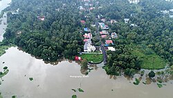
Vallakkunnu is a small village in Aloor Gramapanchayath in the state of Kerala, India. It has a population of around 600 families. The village also holds a portion of Muriyad wetland system, a part of Thrissur kole wet lands.
Kallettumkara is a village which is the epi-centre town of Aloor Panchayat and is in Thrissur district in the state of Kerala. Kaletumkara is the Western border of newly formed Chalakudy Taluk although it elects it Legislative Assembly Candidate from Irinjalakuda Constituency, India. Kalletumkara is popular as the place where Irinjalakuda Railway Station is located and is 8 km (5.0 mi) away from the Irinjalakuda Town.

Mukundapuram Taluk is a taluk (tehsil) in Irinjalakuda Revenue Division of Thrissur district in the Indian state of Kerala. In 1762 this taluk was formed by Cochin King. When new Chalakudy taluk was formed in 2013 it lost majority of its territory. At present the headquarters of the taluk is Irinjalakuda. and It comprises 29 villages.
- Amballur
- Anandapuram
- Chengallur
- Edathirinji
- Irinjalakkuda
- Kaduppassery
- Kallur
- Karalam
- Karumathra
- Kattur
- Kottanellur
- Madayikonam
- Manavalassery
- Muriyad
- Nellayi
- Nenmanikkara
- Padiyur
- Parappukkara
- Poomangalam
- Porathissery
- Pullur
- Puthenchira
- Thekkumkara
- Thoravu
- Thottippal
- Thrikkur
- Vadakkumkara
- Vallivattam
- Velukkara
Vellangallur is a grama panchayath situated in Thrissur district in the Indian state of Kerala.
Chaipankuzhy is a village in Thrissur district, Kerala, India. It is located 16 km from Chalakudy town and 10 km from Athirapilli waterfall. It is in Mukundapuram Taluk, which is in the Chalakudy block.
Aripalam is a village situated in Thrissur district, Kerala, India. Nearest towns are Irinjalakuda and Kodungallore. Main highlight of the village is it is a place between two main roads they are Thrissur - Kodungallur SH22 and Panvel - Edappally Road to connecting NH17 - NH47.
Parekkattukara is a small village in Thrissur district, Kerala, India, with a population of around 1000 families. It is surrounded by other villages such as Kallettumkara, Muriyad, Karoor, Alathur, Manakulangara, and Tharayilakadu. It is part of Muriyad revenue village. The nearest towns are Kodakara, Irinjalakuda, and Chalakkudy.
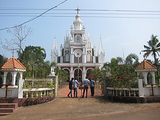
St. Joseph Church, Aloor is a parish of the Syro-Malabar Catholic Church in Aloor. It was the first parish church in Aloor Muri of the Mukundapuram and Kodassery taluks. Aloor parish is one of the 83 parishes between the Bharathappuzha and Periyar rivers, during the erection of syro-Malabar hierarchy and Trichur Vicariate.
Thrissur District has four types of administrative hierarchies:
Chalakudy taluk comes under Irinjalakuda Revenue Division of Thrissur district in Kerala, India. It is one of the 77 taluks of Kerala. Chalakudy taluk was formed in the year 2013 by the UDF Government, led by Oommen Chandy. 31 villages from the former subdistrict of Mukundapuram taluk form the new subdistrict.