
The A5, the London-Holyhead trunk road, is a major road in England and Wales. It runs for about 243 miles (391 km) from London to the Irish Sea at the ferry port of Holyhead. In many parts the route follows that of the Roman Iter II route which later took the Anglo-Saxon name Watling Street.
The N8 road is a national primary road in Ireland, connecting Cork with Dublin via the M7. The N8 is further classified by the United Nations as the entirety of the European route E 201, part of the trans-Europe International E-road network. The road is motorway standard from junction 19 on the M7 to the Dunkettle interchange in Cork City and is designated as the M8 motorway. From here the route continues into Cork city centre and terminates at the N22 road at St. Patrick's Street. The M8 motorway was completed in May 2010, replacing the single carriageway sections of the old N8 and bypassing towns on the main Cork to Dublin road. It is now possible to travel from Cork to Dublin on the M/N8 in about 2 hours 30 minutes. The route commences just south of Portlaoise, and reaches Cork via the midlands and the Golden Vale of Ireland, through Counties Laois, Kilkenny, Tipperary, Limerick and Cork.
Richard Turner (1798–1881) was an Irish iron founder and manufacturer of glasshouses, born in Dublin. He is rated as one of the most important glasshouse designers of his time. His works included the Palm House at Kew Gardens, the glasshouse in the Winter Gardens at Regent's Park in London, the Palm House at Belfast Botanic Gardens and the Curvilinear Range at the Irish National Botanic Gardens, Glasnevin, Ireland.

The Irish Rebellion of 1798 was a popular insurrection against the British Crown in what was then the separate, but subordinate, Kingdom of Ireland. The main organising force was the Society of United Irishmen. First formed in Belfast by Presbyterians opposed to the landed Anglican establishment, the Society, despairing of reform, sought to secure a republic through a revolutionary union with the country's Catholic majority. The grievances of a rack-rented tenantry drove recruitment.
The N3 road is a national primary road in the Republic of Ireland, running between Dublin, Cavan and the border with County Fermanagh. The A509 and A46 roads in Northern Ireland form part of an overall route connecting to Enniskillen, and northwest to the border again where the N3 reappears to serve Ballyshannon in County Donegal.

The N81 road is a national secondary road in Ireland, from the M50 motorway to Tullow, County Carlow, north to south. The N81 continues past Tullow for another 8 km to terminate at the village of Closh, County Carlow, where it intersects the N80. The N81 is 76.784 km (47.711 mi) long. The road is a dual carriageway between M50 motorway and west of Tallaght, known as the Tallaght Bypass or Blessington Road. It intersects with the M50 motorway at Junction 11. There are plans to extend the dual carriageway by 5 km (3.1 mi) to the urban boundary.

European route E20 is a part of the United Nations International E-road network. It runs roughly west–east through Ireland, the United Kingdom, Denmark, Sweden, Estonia, and Russia.

The R148 road is one of Ireland's regional roads which was classified following the opening of a by-passed national primary road.

Enfield, also known as Innfield, is a town in south County Meath, Ireland, situated between Kilcock and Kinnegad and very close to the border with County Kildare. The town is on the Dublin-Sligo railway line. It is located on the R148 regional road, formerly the N4 national primary road connecting Dublin to Connacht.

Baggot Street is a street in Dublin, Ireland.

Clonard is a small village in County Meath, Ireland. It lies on the R148 regional road between the towns of Kinnegad and Enfield. This road was the main road between Dublin and Galway until the construction of the M4 motorway. It is still used by traffic avoiding the toll on the M4.

The R115 road is a regional road in counties Dublin and Wicklow in Ireland. It follows the Military Road for its entire length. The R115 is 40.5 km (25.2 mi) long; the full length of the Military Road is 57.9 km (36.0 mi).

The R639 road is one of Ireland's regional roads. Once designated the N8 national primary road, it was reclassified in stages as the R639 following the progressive opening of sections of the M8 motorway, which rendered the single carriageway N8 redundant as a national primary road. By-passed sections of the old N8 were generally reclassified as R639 as soon as a new section of M8 opened, thereby increasing the length of the R639. With the completion of the M8 on 28 May 2010, the R639 now stretches from Durrow, County Laois to Cork, running through counties Laois, Kilkenny, Tipperary, Limerick and Cork.

The R110 road is a regional road in Ireland which goes from St Stephen's Green to Red Cow, Dublin. Its route is completely within the Dublin urban area.

Goresbridge is a small village located in the east of County Kilkenny, in the province of Leinster, Ireland. Goresbridge is named after a 1756 bridge, built by Colonel Ralph Gore, which provides a crossing of the River Barrow between County Kilkenny and County Carlow in the South-East region.
Edward Hay (1761–1826) was the author of a book on the Irish Rebellion of 1798, and a witness to many of the events of that time.
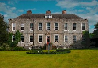
Castlemartin is the name of a historic house and estate, and the townland in which they sit, on the banks of the River Liffey in Kilcullen, County Kildare, Ireland. Formerly a key estate of the Eustace family, it was for many years the home of media magnate Tony O'Reilly, and his wife, Chryss Goulandris, but was bought in 2015 by John Malone, an Irish American. The estate includes major stud farm and cattle breeding operations, a restored medieval church and an icehouse.

Samuel Beckett Bridge is a cable-stayed swingbridge in Dublin, Ireland that joins Sir John Rogerson's Quay on the south side of the River Liffey to Guild Street and North Wall Quay in the Docklands area.

The R112 road is a regional road in south Dublin, Ireland. It begins at the junction with the R148 road at Chapelizod and arcs southeastwards, then eastwards across the middle of south Dublin, ending at the Mount Merrion junction of the R138. The road is a single carriageway, with cycle lanes on some stretches. Improvements to the road have been made over the last 10 years, the most significant being at Dundrum Cross where the road was widened to make room for the new Luas bridge and Dundrum bypass.

Wexford Bridge is a road bridge in Wexford, the county town of County Wexford in Ireland. It crosses the mouth of the River Slaney from Wexford town on the west bank to Ferrybank on the east bank. It carries the R741 road from Wexford towards Dublin and the north. The bridge consists of 7 spans of maximum length 63 metres and 12 metres wide, made of continuous steel girders carrying composite concrete slabs. Including the approach roads, the total length of the bridge is 590 metres, of which 380 metres are over water.

