
The Murrumbidgee River is a major tributary of the Murray River within the Murray–Darling basin and the second longest river in Australia. It flows through the Australian state of New South Wales and the Australian Capital Territory, descending 1,500 metres (4,900 ft) over 1,485 kilometres (923 mi), generally in a west-northwesterly direction from the foot of Peppercorn Hill in the Fiery Range of the Snowy Mountains towards its confluence with the Murray River near Boundary Bend.

The Molonglo River is a perennial river that is part of the Murrumbidgee catchment within the Murray–Darling basin. It is located in the Monaro and Capital Country regions of New South Wales and the Australian Capital Territory, in Australia.

The Namoi River, a major perennial river that is part of the Barwon catchment of the Murray–Darling basin, is located in the Northern Tablelands and North West Slopes districts of New South Wales, Australia.

Kings Highway is an interstate highway located within the Australian Capital Territory and New South Wales, Australia. The highway connects Canberra with Batemans Bay on the South Coast. It is designated route B52.

Lake Parramatta is a heritage-listed man-made reservoir and a recreational area located in North Parramatta, City of Parramatta, in the Western Sydney region of New South Wales, Australia. The masonry arch-walled dam across Hunts Creek was completed in 1856 to supply water for domestic purposes; and was operational until 1909. The dam has since been decommissioned and the lake and the surrounding nature reserve are a popular recreational area.

The Wombeyan Caves are caves that have formed in marble, in the Wombeyan Karst Conservation Reserve, New South Wales, Australia. Wombeyan Caves is a tourist attraction and local holiday area, as well as a reserve for endangered species, such as several species of wallaby, bird, possum, and wombat.
Michelago is a village in the Monaro region of New South Wales, Australia. The village is in the Snowy Monaro Regional Council local government area, 54 kilometres (34 mi) south of Canberra on the Monaro Highway. It was founded in the 1820s, on the main route from Sydney to the Snowy Mountains. Its name is also applied to the surrounding area, for postal and statistical purposes. At the 2016 census, Michelago had a population of 562.

The Queanbeyan River, a perennial stream that is part of the Molonglo catchment within the Murray–Darling basin, is located in the Monaro and Capital Country regions of New South Wales and the Australian Capital Territory, in Australia. The river is 104 kilometres (65 mi) in length with a catchment area of 96,000 hectares. The Queanbeyan River and the Cotter River meet the potable water supply needs of the Canberra and Queanbeyan region and whose water quality is specifically protected under Federal legislation.
Uriarra Village is a town in the district of Coree, in the Australian Capital Territory in Australia. It is situated on the western side of the Australian Capital Territory, about 30 minutes from Canberra, established in 1928 at the foothills of the Australian Alps. A nearby area to the north of the border in New South Wales is also called Uriarra.

Googong Dam is a minor ungated earth and rock fill with clay core embankment dam with concrete chute spillway plus a nearby 13 metres (43 ft) high earthfill saddle embankment across the Queanbeyan River upstream of Queanbeyan in the Capital Country region of New South Wales, Australia. The dam's purpose includes water supply for Canberra and Queanbeyan. The impounded reservoir is called Googong Reservoir.

Googong is a locality located within the Queanbeyan–Palerang Regional Council government area, south of the Queanbeyan Central Business District (CBD).

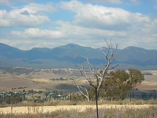
Burra is an Australian locality of rural smallholdings lying 20 kilometres to the south of Queanbeyan, New South Wales in the Queanbeyan-Palerang Region. At the 2021 census, Burra had a population of 790 people.
Keewong Parish is a parish of Murray County, New South Wales, a cadastral unit for use on land titles. A small part of the north-western end of the parish around 35°34′40″S149°07′28″E between the Murrumbidgee River and the Queanbeyan-Cooma railway line was transferred to the Australian Capital Territory in 1909. The southern ends of portions 177, 218, 211, 36, and 38 in the Parish of Keewong form part of the border of the ACT with New South Wales, which is mentioned in the Seat of Government Acceptance Act of 1909.

Carwoola is a locality in the state of New South Wales, Australia. It is immediately to the south of the Kowen district, which is located in the Australian Capital Territory. The Molonglo River passes through the Carwoola area before opening out into the Molonglo Plains. The Kings Highway and Captains Flat Road are the two major through routes. Carwoola is part of the Queanbeyan-Palerang Regional Council and the Southern Tablelands geographic area. The area also roughly aligns with the original Carwoola Parish.

The Cliefden Caves is a heritage-listed geoheritage site in Mandurama, Cowra Shire, New South Wales, Australia. The caves comprise Ordovician fossil localities, limestone caves, a spring and tufa dams, and a site where limestone was first discovered in inland Australia.
The Burra Creek, a mostly–perennial river that is part of the Murrumbidgee catchment within the Murray–Darling basin, is located in the South West Slopes region of New South Wales, Australia.
The Burra Creek, a mostly–perennial river that is part of the Murrumbidgee catchment within the Murray–Darling basin, is located in the Monaro and Southern Tablelands regions of New South Wales, Australia.

Queanbeyan–Palerang Regional Council is a local government area located in the Southern Tablelands region of New South Wales, Australia. The council was formed on 12 May 2016 through a merger of the City of Queanbeyan and Palerang Council.
Googong Foreshores is a heritage-listed historic precinct at London Bridge Road, Burra, New South Wales, Australia. It consists of the historic surroundings of the Googong Dam that predated the dam itself. It is also known as the Googong Foreshores Cultural and Geodiversity Heritage Areas. It was added to the Australian Commonwealth Heritage List on 3 November 2017.
Nerang–Murwillumbah Road is a continuous 36.4 kilometres (22.6 mi) road route in the Gold Coast region of Queensland, Australia. The entire road is signed as State Route 97. Nerang–Murwillumbah Road is a state-controlled district road, rated as a local road of regional significance (LRRS).

