Gallery
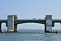 Long Creek Bridge
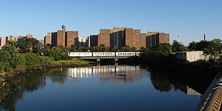
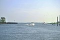 Looking toward Long Creek from Freeport's Woodcleft Canal
 Looking toward Freeport's "Nautical Mile" along Woodcleft Canal from Long Creek
Long Creek is a salt-water channel running roughly north from South Oyster Bay toward Freeport, New York. [1] [2]
It is spanned by the Long Creek Bridge. [3]


Allen is a home rule-class city in Floyd County, Kentucky, in the United States. The population was 193 at the 2010 census, up from 150 at the 2000 census.
Freeport is a village in the Town of Hempstead, in Nassau County, on the South Shore of Long Island, in New York, United States. The population was 43,713 at the 2010 census, making it the second largest village in New York by population.
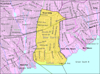
West Islip is a hamlet and CDP located in the Town of Islip in Suffolk County, New York, United States. Situated on the South Shore of Long Island, the population of the CDP was 28,335 at the time of the 2010 census.

Freeport is a borough in Armstrong County in the U.S. state of Pennsylvania; it is situated along the Allegheny River in the southwest corner of the county. The population was 1,813 at the 2010 Census.

Bernville is a borough in Berks County, Pennsylvania, United States. The population was 955 at the 2010 census. Bernville is bordered by Penn Township to the north, east, and south and by Jefferson Township to the west.

The Harlem River is an 8-mile (13 km) tidal strait in New York, United States, flowing between the Hudson River and the East River and separating the island of Manhattan from the Bronx on the New York mainland.

The Narrows is the tidal strait separating the boroughs of Staten Island and Brooklyn in New York City, United States. It connects the Upper New York Bay and Lower New York Bay and forms the principal channel by which the Hudson River empties into the Atlantic Ocean. It has long been considered to be the maritime "gateway" to New York City and historically has been one of the most important entrances into the harbors of the Port of New York and New Jersey.
Coney Island Creek is a 1.8-mile-long (2.9 km) tidal inlet in Brooklyn, New York City. It used to be a 3-mile-long (4.8 km) continual strait and a partial mudflat connecting Gravesend Bay and Sheepshead Bay, making Coney Island an actual island, but the eastern half of the creek was filled in by land owners and city construction projects during a period spanning the early to mid 20th century.

Swatara Creek is a 72-mile-long (116 km) tributary of the Susquehanna River in east-central Pennsylvania in the United States. It rises in the Appalachian Mountains in central Schuylkill County and passes through northwest Lebanon County before draining into the Susquehanna at Middletown in Dauphin County.

Spuyten Duyvil Creek is a short tidal estuary in New York City connecting the Hudson River to the Harlem River Ship Canal and then on to the Harlem River. The confluence of the three water bodies separate the island of Manhattan from the Bronx and the rest of the mainland. Once a distinct, turbulent waterway between the Hudson and Harlem rivers, the creek has been subsumed by the modern ship canal.

Forsyth Street runs from Houston Street south to Henry Street in the New York City borough of Manhattan. The street was named in 1817 for Lt. Colonel Benjamin Forsyth.

Gowanus is a neighborhood in the northwestern portion of the New York City borough of Brooklyn, within the area once known as South Brooklyn. The neighborhood is part of Brooklyn Community District 6. Gowanus is bounded by Wyckoff Street on the north, Fourth Avenue on the east, the Gowanus Expressway to the south, and Bond Street to the west.

Saint Georges is an unincorporated town and former municipality situated on the Chesapeake and Delaware Canal in New Castle County, Delaware, about midway between the Delaware River and Chesapeake Bay.

The Broadway Bridge is a vertical-lift bridge across the Harlem River Ship Canal in the borough of Manhattan in New York City. It connects the neighborhoods of Inwood on Manhattan Island and Marble Hill on the mainland. The bridge consists of two decks. The lower deck carries Broadway, which is designated as U.S. Route 9 at this location. The upper deck carries the New York City Subway's IRT Broadway–Seventh Avenue Line, serving the 1 train.
Vanderbilt Avenue is the name of three thoroughfares in the New York City boroughs of Brooklyn, Manhattan, and Staten Island. They were named after Cornelius Vanderbilt (1794–1877), the builder of Grand Central Terminal in Midtown Manhattan.
Money Creek Township is located in McLean County, Illinois. As of the 2010 census, its population was 1,085 and it contained 511 housing units.

Zieglerville is an unincorporated community in Lower Frederick Township, Montgomery County, Pennsylvania, United States. Its ZIP Code is 19492 and it is located on the west side of the Perkiomen Creek where Route 29 and Route 73 split at a roundabout just north of Schwenksville.

Hempstead Harbor is a bay hugging the northern coast of Long Island, New York. Located off of the Long Island Sound, it forms the northernmost portion of the political border between the Nassau County towns of Oyster Bay on the east and North Hempstead on the west, as well as the western border of the city of Glen Cove.

The East River Greenway is an approximately 9.44-mile-long (15.19 km) foreshoreway for walking or cycling on the east side of the island of Manhattan on the East River. It is part of the Manhattan Waterfront Greenway. The largest portions are operated by the New York City Department of Parks and Recreation. It is separated from motor traffic, and many sections also separate pedestrians from cyclists. The greenway is parallel to the Franklin D. Roosevelt East River Drive for a majority of its length.
Doanesburgh is an extinct locality in Putnam County, in the U.S. state of New York.
| Wikimedia Commons has media related to Long Creek (New York) . |
| | This article about a location in Nassau County, New York is a stub. You can help Wikipedia by expanding it. |