
Longdendale is a valley in the Peak District of England, north of Glossop and southwest of Holmfirth. The name means "long wooded valley" and the valley is mostly in the counties of Derbyshire and Greater Manchester.

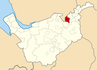
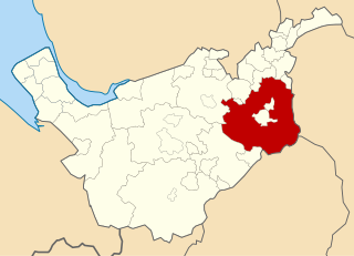
The Metropolitan Borough of Tameside is a metropolitan borough of Greater Manchester in England. It is named after the River Tame, which flows through the borough, and covers the towns of Ashton-under-Lyne, Audenshaw, Denton, Droylsden, Dukinfield, Hyde, Mossley and Stalybridge. Tameside is bordered by the metropolitan boroughs of Stockport to the south, Oldham to the north and northeast, Manchester to the west, and to the east by the Borough of High Peak in Derbyshire. As of 2011 the overall population was 219,324. It is also the 8th-most populous borough of Greater Manchester by population.

Ellesmere Port and Neston was, from 1974 to 2009, a local government district with borough status in Cheshire, England. It covered the southern part of the Wirral Peninsula, namely that part which is not included in the Metropolitan Borough of Wirral.

High Peak is a local government district with borough status in Derbyshire, England, covering a high moorland plateau in the Dark Peak area of the Peak District National Park. The district stretches from Holme Moss in the north to Sterndale Moor in the south, and from Hague Bar in the west to Bamford in the east. The population of the borough taken at the 2011 Census was 90,892. The borough is unusual in having two administrative centres for its council, High Peak Borough Council; the offices are in Buxton and Glossop. Other towns include Chapel-en-le-Frith, Hadfield, New Mills and Whaley Bridge.

Stalybridge and Hyde is a constituency represented in the House of Commons of the UK Parliament since 2010 by Jonathan Reynolds, a member of Labour Co-op.

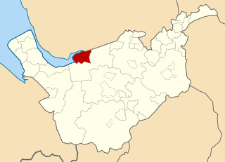
Tintwistle Rural District was a local government district in north east Cheshire, England from 1894 to 1974.
Cheadle and Gatley was, from 1894 to 1974, an urban district of Cheshire, England.

Hazel Grove and Bramhall was a civil parish and urban district in north east Cheshire, England from 1900 to 1974.
Swinton and Pendlebury was a local government district of the administrative county of Lancashire, England. It was created in 1894 as an urban district and enlarged in 1934, gaining the status of a municipal borough.
Bucklow Rural District was, from 1894 to 1974, a local government district in the north of the administrative county of Cheshire, England. Following the Local Government Act 1972, this rural district was split between the new Greater Manchester boroughs of Trafford and Manchester, and Macclesfield, which was retained in Cheshire.
Cheshire County Council was the county council of Cheshire. Founded on 1 April 1889, it was officially dissolved on 31 March 2009, when it and its districts were superseded by two unitary authorities; Cheshire West and Chester and Cheshire East.
Macclesfield Rural District was a rural district of Cheshire, England from 1894 to 1974.

The Local Government Act 1958 was an Act of the Parliament of the United Kingdom affecting local government in England and Wales outside London. Among its provisions it included the establishment of Local Government Commissions to review the areas and functions of local authorities, and introduced new procedures for carrying these into action.

Sale was, from 1867 to 1974, a district in Cheshire, England. The district had in turn the status of local government district, urban district and municipal borough. Its area now forms part of the Metropolitan Borough of Trafford, Greater Manchester.

Matley is a semi-rural area of Greater Manchester, England, between Stalybridge, Hyde and Dukinfield. Matley was a township of Mottram in Longdendale, one of the eight ancient parishes of the Macclesfield Hundred of Cheshire. Under the Poor Law Amendment Act 1886 the township became a civil parish in its own right.

Mottram in Longdendale was one of the eight ancient parishes of the Macclesfield Hundred of Cheshire, England. Centred on St Michael and All Angels Church it included the townships of Godley, Hattersley, Hollingworth, Matley, Newton, Stayley, Tintwistle and Mottram itself. Under the Poor Law Amendment Act 1886 the townships became civil parishes in their own right.

The Municipal Borough of Widnes was a municipal borough centred around the town of Widnes in Lancashire, England from 1892 until 1974.
Runcorn Urban District was an urban district centred around the town of Runcorn in Cheshire, England from 1894 until 1974.

Buxton was an Urban District from 1894 to 1917 and a Municipal Borough from 1917 to 1974 in Derbyshire, England.
The ceremonial county of Cheshire, which comprises the unitary authorities of Cheshire East, Cheshire West and Chester, Halton and Warrington, has returned 11 MPs to the UK Parliament since 1997.

