Longdendale is a valley in the Peak District of England, north of Glossop and southwest of Holmfirth. The name means "long wooded valley" and the valley is mostly in the counties of Derbyshire and Greater Manchester.

Tameside is a metropolitan borough of Greater Manchester, England, named after the River Tame, which flows through it, and includes the towns of Ashton-under-Lyne, Audenshaw, Denton, Droylsden, Dukinfield, Hyde, Mossley and Stalybridge. Tameside is bordered by the metropolitan boroughs of Stockport to the south, Oldham to the north and northeast, Manchester to the west, and to the east by the Borough of High Peak in Derbyshire. As of 2022, the population of Tameside was 232,753, making it the 8th-most populous borough of Greater Manchester.

The River Etherow in northern England is a tributary of the River Goyt. Although now passing through South Yorkshire, Derbyshire and Greater Manchester, it historically formed the ancient county boundary between Cheshire and Derbyshire. The upper valley is known as Longdendale. The river has a watershed of approximately 30 square miles (78 km2), and the area an annual rainfall of 52.5 inches (1,330 mm).

Stalybridge is a town in Tameside, Greater Manchester, England, with a population of 23,731 at the 2011 Census.

The M67 is a 5-mile-long (8 km) urban motorway in Greater Manchester, England, which heads east from the M60 motorway passing through Denton and Hyde before ending near Mottram. The road was originally conceived as the first section of a trans-Pennine motorway between Manchester and Sheffield that would connect the A57(M) motorway with the M1 motorway; however, the motorway became the only part to be built.

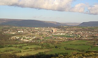
Hyde is a town in Tameside, Greater Manchester, England, which had a population of 35,890 in 2021. Within the boundaries of the historic county of Cheshire, it is 5 miles (8 km) north-east of Stockport, 6 miles (10 km) west of Glossop and 6.5 miles (10 km) east of Manchester.

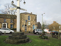
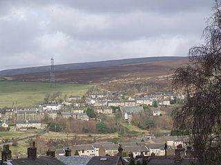
Hollingworth is a village in the Tameside district, in Greater Manchester, England. It is about 11 miles (19 km) east of Manchester on the Derbyshire border near Glossop. Historically part of Cheshire, it gave its name to a family who owned much of the surrounding area from before the time of the Norman conquest.
Hattersley is an area of Tameside, Greater Manchester, England; it is located 4 miles (6.4 km) west of Glossop and 10 miles (16 km) east of Manchester, at the eastern terminus of the M67. Historically part of Tintwistle Rural District in Cheshire until 1974, it is the site of an overspill estate built by Manchester City Council in the 1960s.

Hadfield is a town in the High Peak of Derbyshire, England, with a population at the 2021 Census of 6,763. It lies on the south side of the River Etherow, near to the border with Greater Manchester, at the western edge of the Peak District close to Glossop. It doubled as the fictional town of Royston Vasey in the BBC comedy series The League of Gentlemen.
Tintwistle is a village and civil parish in the High Peak district of Derbyshire, England, which had a population of 1,400 at the 2011 census. The village is just north of Glossop at the lower end of Longdendale Valley. Tintwistle, like nearby Crowden and Woodhead, lies within the historic county boundaries of Cheshire.

Stalybridge and Hyde is a constituency in Greater Manchester that was created in 1918. The seat has been represented in the House of Commons of the Parliament of the United Kingdom by Jonathan Reynolds of the Labour and Co-operative Party since 2010. Reynolds currently serves as Secretary of State for Business and Trade under the government of Keir Starmer.

Tintwistle Rural District was a local government district in north east Cheshire, England from 1894 to 1974.
Hyde was a county constituency represented in the House of Commons of the Parliament of the United Kingdom from 1885 until 1918. It was seated in the town of Hyde, Cheshire.

Godley is a suburb of Hyde, Greater Manchester, England.

The Longdendale Bypass is a long-planned National Highways road scheme in the Tameside and High Peak districts in England. Its aim is to alleviate traffic congestion on the A57, A628, and A616 routes that presently pass through the villages. There is both support and opposition for this long-planned scheme, which will pass through the valley of Longdendale and part of the Peak District National Park.

Matley is a semi-rural area in the Tameside district, in Greater Manchester, England, between Stalybridge, Hyde and Dukinfield.

Longdendale Urban District was, from 1936 to 1974, a local government district in the administrative county of Cheshire, England. It encompassed parts of Broadbottom, Hattersley, Hollingworth, Matley and Mottram in Longdendale, all forming part of the non-statutory Longdendale Valley.

The A628 is a major road connecting Greater Manchester and South Yorkshire in northern England. It crosses the Pennine hills by way of Longdendale and the Woodhead Pass in the Peak District National Park. The road's altitude and exposure to bad weather create problems in winter and the road is sometimes closed due to snow or high winds.
Newton is an area of Hyde, in the Tameside district, in Greater Manchester, England; it occupies a narrow strip of land from the River Tame, near Newton Hall, to Matley, between Hyde and Dukinfield.