Related Research Articles
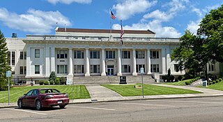
Douglas County is one of the 36 counties in the U.S. state of Oregon. As of the 2020 census, the population was 111,201. The county seat is Roseburg. The county is named after Stephen A. Douglas, an American politician who supported Oregon statehood. Douglas County comprises the Roseburg, OR Micropolitan Statistical Area. In regards to area, Douglas County is the largest county west of the Oregon Cascades.
A looking glass is an object whose surface reflects an image.
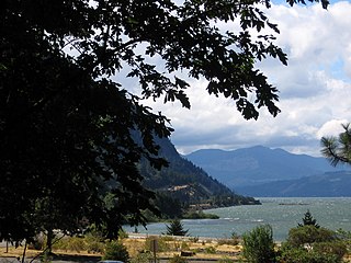
Starvation Creek State Park is a state park located west of Hood River, Oregon in the Columbia River Gorge. It was named Starvation Creek because a train was stopped there by snow drifts and passengers had to dig out the train. No one starved there.

Chandler State Wayside is a state park in south-central Oregon in the United States. It is named in honor of Solomon and Hattie Chandler, who donated the land for the park. The park covers 85 acres (34 ha) of pine forest along a creek. The park provides restrooms and other basic facilities to accommodate the traveling public. Chandler State Wayside is administered by the Oregon Parks and Recreation Department.

The Bridge Creek Wildlife Area is a wildlife management area located near Ukiah, Oregon, United States. The location was set aside in 1961 as a wintering area for elk.

Catherine Creek State Park is a state park along Catherine Creek in the U.S. state of Oregon, administered by the Oregon Parks and Recreation Department.
Fall Creek State Recreation Site is a state park in the U.S. state of Oregon, administered by the Oregon Parks and Recreation Department. The park includes 47 campsites that do not include many luxuries. Each site includes a picnic table and a fire ring. There is also a designated swimming area in the lake that Fall Creek flows into. A dock and boat ramp are on the lake as well.

Fogarty Creek State Recreation Area is a state park in the U.S. state of Oregon, administered by the Oregon Parks and Recreation Department.

Munson Creek Falls State Natural Site is a state park in the U.S. state of Oregon, administered by the Oregon Parks and Recreation Department. The park contains Munson Creek Falls, which is the tallest waterfall in Oregon's Coast Range. A short hike of 0.5 miles (0.80 km) leads to views of the 319 feet (97 m) waterfall.

Rocky Creek State Scenic Viewpoint is a state park in Lincoln County in northwestern Oregon, United States. Administered by the Oregon Parks and Recreation Department, the 59-acre (24 ha) park lies along a bluff between Whale Cove and Rocky Creek. The park extends south along the Otter Crest Loop Road to the Rocky Creek Bridge.

The Trout Creek Mountains are a remote, semi-arid Great Basin mountain range mostly in southeastern Oregon and partially in northern Nevada in the United States. The range's highest point is Orevada View Benchmark, 8,506 feet (2,593 m) above sea level, in Nevada. Disaster Peak, elevation 7,781 feet (2,372 m), is another prominent summit in the Nevada portion of the mountains.
Tollgate is an unincorporated community in Umatilla County, Oregon, United States. It lies between Weston and Elgin on Oregon Route 204.

Lookingglass is an unincorporated community and census-designated place in the Lookingglass Valley of Douglas County, Oregon, United States, about 9 miles (14 km) southwest of Roseburg. As of the 2010 census it had a population of 855. Lookingglass is considered a suburb of Roseburg.

McKay Creek National Wildlife Refuge is a United States National Wildlife Refuge located between plains and the Blue Mountains of Eastern Oregon. The refuge provides habitat for rare and endangered species and breeding and migratory birds. The lack of other local wetland habitats elevates the importance of this refuge as a home to a variety of wildlife and plant species in an arid environment.

Langdon Lake is reservoir located in the Umatilla National Forest of Northeastern Oregon, United States. It is an impoundment of Morning Creek, and the source of Lookingglass Creek, a tributary of the Grande Ronde River.

Brockway is an unincorporated community in Douglas County, Oregon, United States, on Oregon Route 42, about nine miles southwest of Roseburg.

The James Wimer Octagonal Barn is a barn in Lookingglass, Oregon, in the United States. It was built in 1892 and was added to the National Register of Historic Places on December 2, 1985.
The Bushnell Rock Member is a geologic rock formation, named after an outcropping of an exposed portion of the member itself known as Bushnell Rock by University of Oregon Geologist Ewart M. Baldwin in 1974. This combined with Tenmile Member and Olalla Creek Member makeup the larger Lookingglass Formation lying beneath the Lookingglass Valley in Douglas County, Oregon.
References
- ↑ "Lookingglass Creek". Geographic Names Information System . United States Geological Survey, United States Department of the Interior. November 28, 1980. Retrieved August 4, 2011.