
Ilwaco is a city in Pacific County, Washington, United States. The population was 936 at the 2010 census. Founded in 1890, the city was home to the Ilwaco Railway and Navigation Company along the Long Beach Peninsula, with its core economy based on logging and timber rafting. The city is located on the southern edge of the Long Beach Peninsula, on Baker Bay on the north side of the Columbia River where it meets the Pacific Ocean. It is near the city of Astoria, Oregon, which lies to the southeast on the southern bank of the Columbia.

Long Beach is a city in Pacific County, Washington, United States. The population was 1,392 at the 2010 census.

Ocean Park is a census-designated place (CDP) in Pacific County, Washington, United States. The population was 1,573 at the 2010 census. It is on the Long Beach Peninsula, north of Long Beach, Washington.

Hull is a town in Plymouth County, Massachusetts, United States, located on a peninsula at the southern edge of Boston Harbor. Its population was 10,072 at the 2020 census. Hull is the smallest town by land area in Plymouth County and the fourth smallest in the state. However, its population density is nearly four times that of Massachusetts as a whole.

The Columbia Bar, also frequently called the Graveyard of the Pacific, is a system of bars and shoals at the mouth of the Columbia River spanning the U.S. states of Oregon and Washington. It is known as one of the most dangerous bar crossings in the world. The bar is about 3 miles (5 km) wide and 6 miles (10 km) long.
The Coast Line is a railroad line between Burbank, California and the San Francisco Bay Area, roughly along the Pacific Coast. It is the shortest rail route between Los Angeles and the Bay Area.

The Long Beach Peninsula is an arm of land on the southern coast of the state of Washington in the United States. Entirely within Pacific County, it is bounded on the west by the Pacific Ocean, the south by the Columbia River, and the east by Willapa Bay. Leadbetter Point State Park and Willapa National Wildlife Refuge are at the northern end of the peninsula and Cape Disappointment is at the southern end, with Pacific Pines State Park located in between.

Oysterville is an unincorporated community located along Willapa Bay on the Long Beach Peninsula in Pacific County, Washington, United States. It is approximately 5 miles (8.0 km) from the city of Ocean Park, and 15 miles (24 km) from Long Beach. Founded in 1841 as an oyster fishing village, the community is registered on the National Register of Historic Places as the Oysterville Historic District. It currently has a population of about 20 residents.

Beaumont Provincial Park is a provincial park located at the southeast end of Fraser Lake, between Fort Fraser and the town of Fraser Lake, British Columbia, approximately 40 km west of Vanderhoof, British Columbia. The park contains the site of the original Fort Fraser.
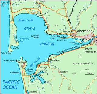
Grays Harbor is an estuarine bay located 45 miles (72 km) north of the mouth of the Columbia River, on the southwest Pacific coast of Washington state, in the United States of America. It is a ria, which formed at the end of the last ice age, when sea levels flooded the Chehalis River. The bay is 17 miles (27 km) long and 12 miles (19 km) wide. The Chehalis River flows into its eastern end, where the city of Aberdeen stands at that river's mouth, on its north bank, with the somewhat smaller city of Hoquiam immediately to its northwest, along the bayshore. Besides the Chehalis, many lesser rivers and streams flow into Grays Harbor, such as Hoquiam River and Humptulips River. A pair of low peninsulas separate it from the Pacific Ocean, except for an opening about two miles (3 km) in width. The northern peninsula, which is largely covered by the community of Ocean Shores, ends in Point Brown. Facing that across the bay-mouth is Point Chehalis, at the end of the southern peninsula upon which stands the town of Westport.
The Ilwaco Railway and Navigation Company operated a 3 ft narrow gauge railroad that ran for over forty years from the bar of the Columbia River up the Long Beach Peninsula to Nahcotta, Washington, on Willapa Bay. The line ran entirely in Pacific County, Washington, and had no connection to any outside rail line. The railroad had a number of nicknames, including the "Clamshell Railroad" and the "Irregular, Rambling and Never-Get-There Railroad."
Seaview is an unincorporated community in Pacific County, Washington. It is located near Long Beach and had a population for its 98644 ZIP code at the 2010 census of 473 people.

Nahcotta is an unincorporated community in Pacific County, in the American state of Washington. It is located on Willapa Bay, on the eastern coast of the Long Beach Peninsula, within the Ocean Park CDP.

Klipsan Beach was the site of a station of the United States Life-Saving Service. The station buildings still remain, although they are privately owned. The station is on the National Register of Historic Places. The station's name was originally Ilwaco Beach, and only later became known as Klipsan Station. The station was one of several assigned to provide protection in the area known as the Graveyard of the Pacific.

McGowan was a stop on the Ilwaco Railway and Navigation Company's narrow gauge line that ran on the Long Beach Peninsula in Pacific County, Washington, United States from 1889 to 1930. In the late 19th century, P.J. McGowan bought land in the area for $1,200, and built his house, a dock and a salmon cannery on the site. During the railroad times, the main line and a passing siding ran through McGowan. McGowan is just west of the north end of the Astoria-Megler Bridge. The only prominent structure remaining is the old wooden Roman Catholic church. From 1925 to 1932, one of the docks of the Astoria-Megler Ferry route was located at McGowan.
Holman was a stop on the Ilwaco Railway and Navigation Company's narrow gauge line that ran on the Long Beach Peninsula in Pacific County, Washington, USA from 1889 to 1930. Development in the area began when James Duval Holman. received a donation land claim on the west side of what is now Ilwaco.
Siltcoos is an unincorporated community in Lane County, Oregon, United States. It is about 13 miles (21 km) south of Florence on the east shore of Siltcoos Lake.

The Astoria–Megler ferry, also called the Astoria–McGowan ferry and the Astoria–North Beach ferry, ran across the Columbia River between Astoria, Oregon, and two ferry docks near the present small community of Megler, Washington, from 1921 to 1966.

Breakers Station was a mail and passenger stop on the Ilwaco Railway and Navigation Company line on the Long Beach Peninsula in Washington. It was originally called Tioga. In 1917 it was listed as a town 5 miles (8.0 km) north of Long Beach, Washington.
Resort subdivision and Ilwaco railroad station at the north boundary of the town of Long Beach in the 1890s and early 1900s. The Tioga Hotel was the main focus of the resort and gave the railroad station its name. The surrounding beach was lined with vacation cottages and tents. J. M. Arthur, proprietor of the hotel, later built the Breakers Hotel in 1901. Tioga is an Iroquois word meaning "where it forks". The hotel and station are long gone. Tioga is now within the city limits of Long Beach. The name is no longer found on maps.

Nahcotta was a steamboat operated from 1898 to 1928 on a route from Astoria, Oregon to Ilwaco, Washington, and then, from 1908 on, from Astoria to Megler, Washington. Nahcotta ran on the same route for its entire service life, and for much of that time was commanded by Capt. Tom Parker, who started his marine career as a deckhand and who had only three months of formal education.