Conception Harbour is a town on the Avalon Peninsula in Newfoundland and Labrador, Canada. It is in Division 1 on Conception Bay and can be accessed via Newfoundland and Labrador Route 60.
Division No. 1, Subdivision A is an unorganized subdivision on the Avalon Peninsula in Newfoundland and Labrador, Canada. It is in Division No. 1, and lies between Trinity Bay and Placentia Bay.
Chapel Arm is a settlement in Newfoundland, Canada, located at the southeast corner of Trinity Bay, approximately 100 km (62 mi) west of St. John's and two km from the Trans-Canada Highway.
Hant's Harbour is an incorporated town located on the east side of Trinity Bay on the Bay de Verde Peninsula in the province of Newfoundland and Labrador, Canada. It has a population of 318 according to the 2021 Canadian census.
Victoria is an incorporated town in Conception Bay located approximately midway on the Bay de Verde Peninsula of Newfoundland and Labrador, Canada.
Hillview-Adeytown is a former local service district and former designated place on the east coast of Newfoundland in Newfoundland and Labrador, Canada that existed from 1999 until 2008. It consisted of the village of Hillview on the Southwest Arm of Trinity Bay and the village of Adeytown on the Northwest Arm of Trinity Bay, just south of Clarenville.
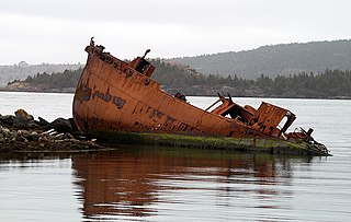
Safe Harbour is an abandoned outport on the northeast coast of Newfoundland in the Canadian province of Newfoundland and Labrador. Settled by 1870, it was abandoned in 1955.

Random Island is an island located off Canada's Atlantic coast. Part of the Province of Newfoundland and Labrador, it is located on the east coast of Newfoundland and partially surrounded by the Bonavista Peninsula on the north and within the confines of Trinity Bay. The island is approximately 35 km (22 mi) long, its width varies from 15 km (9.3 mi) on the eastern end, to 6 km (3.7 mi) in the middle, to 17 km (11 mi) on the western end, with a total area of around 310 km2 (120 sq mi). According to the 2016 census, the population of the island is 1,232.
The Bonavista Peninsula is a large peninsula on the east coast of the island of Newfoundland in the Canadian province of Newfoundland and Labrador. It consists of 50 incorporated towns/unincorporated communities which have a population of 12,176 as of the 2016 Canadian Census. Bonavista is the largest population centre on the peninsula.
New-Wes-Valley is a municipality in Newfoundland and Labrador, Canada.
St. Jones Within is located in Trinity Bay, Newfoundland. It takes approximately two hours to drive there from the province's capital city, St. John's. Its geographical location is: Latitude 480300 and Longitude 534500. Most of the houses in the community are built around the sheltered harbour.
Heart's Delight-Islington is a town on the south side of Trinity Bay in the Canadian province of Newfoundland and Labrador, located on Newfoundland and Labrador Route 80. The Post Office was established in 1954. The first Postmistress was Maggie Chislett.
Centreville–Wareham–Trinity is a town in the Canadian province of Newfoundland and Labrador, located on Bonavista Bay. The town had a population of 1,116 in the Canada 2021 Census, down from 1,147 in 2016.
Burgoyne's Cove is a local service district and designated place in the Canadian province of Newfoundland and Labrador.
Bragg's Island was a settlement in Newfoundland and Labrador.
New Harbour is a local service district and designated place in the Canadian province of Newfoundland and Labrador. It is on the east shore of Trinity Bay, along Provincial Route 80. Route 80's intersection with Route 73 is inside New Harbour.
Haystack was a former fishing settlement located on the northern portion of Long Island, Placentia Bay of the island of Newfoundland in the province of Newfoundland and Labrador, Canada. People from the community freely chose to move to other places in the province during the resettlement program of the 1950s and 60s. Unlike most communities, residents were not paid to leave the community.

Division No. 1, Subdivision E is an unorganized subdivision on the Avalon Peninsula in Newfoundland and Labrador, Canada. It is in Division 1 and contains the unincorporated communities of Broad Cove, Dildo, Green's Harbour, Harnum Point, Hopeall, New Harbour and Reids Room.

Division No. 1, Subdivision G is an unorganized subdivision on the Avalon Peninsula in Newfoundland and Labrador, Canada. It is in Division 1 and contains the unincorporated communities of Baccalieu Island, Besom Cove, Bradley's Cove, Burnt Point, Caplin Cove, Daniel's Cove, Grates Cove, Gull Island, Job's Cove, Kingston, Long Beach, Lower Island Cove, Low Point, Northern Bay, Ochre Pit Cove, Red Head Cove, Riverhead, Smooth Cove and Western Bay.
New Harbour is an abandoned town located within Fortune Bay in Newfoundland and Labrador, Canada that had a peak population of 24 in 1945. It is not to be confused with New Harbour, Trinity Bay and New Harbour on the south-west coast of Newfoundland.
