Avondale is a town located on Newfoundland's Avalon Peninsula in the province of Newfoundland and Labrador, Canada, which was incorporated in 1974. The community is situated at the southwestern head of Conception Bay in Division 1. It is located 59 km (37 mi) southwest of St. John's and 72 km (45 mi) northeast of Placentia.

The Bay of Islands is an extensive inlet located on the west coast of the island of Newfoundland, in Canada. It is a sub-basin of the Gulf of St. Lawrence, consisting of many inlets such as Humber Arm and Goose Arm.

Division 1, Newfoundland and Labrador is a census division covering the entire Avalon Peninsula including the Isthmus of Avalon of the Canadian province of Newfoundland and Labrador. Like all census divisions in Newfoundland and Labrador, but unlike the census divisions of some other provinces, the division exists only as a statistical division for census data, and is not a political entity.
Division No. 8 is a census division on the north coast of the island of Newfoundland in the province of Newfoundland and Labrador, Canada. It has a land area of 9,314.57 km² and had a population of 33,940 at the 2016 census. Its largest communities are the towns of Lewisporte, Springdale, and Twillingate.

Exploits is a provincial electoral district for the House of Assembly of Newfoundland and Labrador, Canada.

The Isles of Notre Dame, formerly called Twillingate and Fogo, is a defunct provincial electoral district for the House of Assembly of Newfoundland and Labrador, Canada. As of 2011 the district had 6,990 eligible voters. The district was abolished in 2015 and largely replaced by Lewisporte-Twillingate.

Lewisporte is a defunct provincial electoral district for the House of Assembly of Newfoundland and Labrador, Canada. As of 2011, there are 7,797 eligible voters living within the district. The district was abolished in 2015 and replaced by Lewisporte-Twillingate.

Baie Verte-Green Bay is a provincial electoral district for the House of Assembly of Newfoundland and Labrador, Canada. As of 2011 it has 8,067 eligible voters. The district was redistributed in 2015.
The Straits – White Bay North is a defunct provincial electoral district for the House of Assembly of Newfoundland and Labrador, Canada. The district was known as Strait of Belle Isle prior to the 1996 election. In the 2007 redistribution, it added five per cent of St. Barbe. As of 2011, there are 6,851 eligible voters living within the district.
Hillview-Adeytown is a former local service district and former designated place on the east coast of Newfoundland in Newfoundland and Labrador, Canada that existed from 1999 until 2008. It consisted of the village of Hillview on the Southwest Arm of Trinity Bay and the village of Adeytown on the Northwest Arm of Trinity Bay, just south of Clarenville.
St. George's Bay - informally referred to as Bay St. George due to its French translation Baie St-George - is a large bay in the province of Newfoundland and Labrador, Canada. It is located on the west coast of the island of Newfoundland and comprises a sub-basin of the Gulf of St. Lawrence.

Area code 709 is the telephone area code in the North American Numbering Plan (NANP) for the entire Canadian province of Newfoundland and Labrador.
The Burin Peninsula is a peninsula located on the south coast of the island of Newfoundland in the province of Newfoundland and Labrador. Marystown is the largest population centre on the peninsula.
Virgin Arm–Carter's Cove is a local service district and designated place on New World Island in the Canadian province of Newfoundland and Labrador. Virgin Arm-Carter's Cove is located approximately 90 km Northwest of Gander in Subdivision H of Division No. 8.
St. Jones Within is located in Trinity Bay, Newfoundland and Labrador. It takes approximately two hours to drive there from the province's capital city, St. John's. Most of the houses in the community are built around the sheltered harbour.

Cox's Cove is a town in the Canadian province of Newfoundland and Labrador. The town had a population of 664 in the Canada 2021 Census. The small community is mainly based on the fishery, mink farm, and construction industries.

Humber Arm South is a town in the Canadian province of Newfoundland and Labrador. The town consists of the communities of Halfway Point, Benoit's Cove, John's Beach, and Frenchman's Cove. The town had a population of 1,537 in the Canada 2021 Census. The Town's Post Office is located in Benoit's Cove. Humber Arm South is located in the Bay of Islands and is in the Humber-Bay of Islands electoral district. The town's residents are of Mi'kmaw, Innu, and European descent.
Hodge's Cove is a local service district and designated place in the Canadian province of Newfoundland and Labrador. It is southeast of Clarenville. Hodge's Cove was settled in 1861 and was first referred to as Hodge's Hole. It is not known for sure, but the settlement's name may have come from visitors who made short trips to the area to cut wood. As early as the 1840s, fisherman from Grates Cove in Trinity Bay came to Southwest Arm looking for wood. The way office was established in 1884 and the first way master was James Drover. It had a population of 261 in 2016.
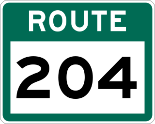
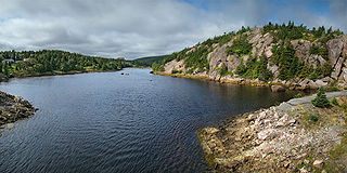
Route 204, also known as Southwest Arm Road, is a 30.5-kilometre-long (19.0 mi) east–west highway on the island of Newfoundland in the province of Newfoundland and Labrador. It connects the communities along the southern shore of the Southwest Arm of Trinity Bay with the Trans-Canada Highway at North West Brook. It is a very curvy two-lane highway traversing very hilly terrain for its entire length.
