
Yawan District is one of the 28 districts of Badakhshan Province in eastern Afghanistan. It was created in 2005 from part of the Ragh District and is home to approximately 20,000 residents.

Obornjača is an uninhabited village in Serbia. It is situated in the Bačka Topola municipality, in the North Bačka District, Vojvodina province.
Mikorzyce is a village in the administrative district of Gmina Wołów, within Wołów County, Lower Silesian Voivodeship, in south-western Poland. Prior to 1945 it was in Germany.
Bądkówek is a village in the administrative district of Gmina Bądkowo, within Aleksandrów County, Kuyavian-Pomeranian Voivodeship, in north-central Poland.

Jradzor is a village in the Shirak Province of Armenia.
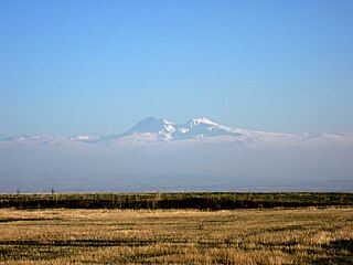
Marmashen is a village in the Shirak Province of Armenia.
Chwaliszewo is a village in the administrative district of Gmina Kcynia, within Nakło County, Kuyavian-Pomeranian Voivodeship, in north-central Poland.
Agnieszkowo is a village in the administrative district of Gmina Lubraniec, within Włocławek County, Kuyavian-Pomeranian Voivodeship, in north-central Poland.

Wyręby is a village in the administrative district of Gmina Biecz, within Gorlice County, Lesser Poland Voivodeship, in southern Poland. It lies approximately 7 kilometres (4 mi) north-west of Biecz, 14 km (9 mi) north of Gorlice, and 96 km (60 mi) east of the regional capital Kraków.
Białobrzegi is a village in the administrative district of Gmina Zamość, within Zamość County, Lublin Voivodeship, in eastern Poland. It lies approximately 10 kilometres (6 mi) north-west of Zamość and 67 km (42 mi) south-east of the regional capital Lublin.
Błogosław is a village in the administrative district of Gmina Błędów, within Grójec County, Masovian Voivodeship, in east-central Poland. The current mayor is Sławomir Bińkiewicz.
Wocławy is a village in the administrative district of Gmina Cedry Wielkie, within Gdańsk County, Pomeranian Voivodeship, in northern Poland. It lies approximately 6 kilometres (4 mi) north-west of Cedry Wielkie, 10 km (6 mi) east of Pruszcz Gdański, and 14 km (9 mi) south-east of the regional capital Gdańsk.
Kokwino is a village in the administrative district of Gmina Sierakowice, within Kartuzy County, Pomeranian Voivodeship, in northern Poland. It lies approximately 5 kilometres (3 mi) north-east of Sierakowice, 19 km (12 mi) west of Kartuzy, and 46 km (29 mi) west of the regional capital Gdańsk.
Rusinowo is a village in the administrative district of Gmina Sadlinki, within Kwidzyn County, Pomeranian Voivodeship, in northern Poland. It lies approximately 10 kilometres (6 mi) south-west of Sadlinki, 18 km (11 mi) south-west of Kwidzyn, and 85 km (53 mi) south of the regional capital Gdańsk.
Żurawki is a settlement in the administrative district of Gmina Osiek, within Starogard County, Pomeranian Voivodeship, in northern Poland. It lies approximately 8 kilometres (5 mi) west of Osiek, 28 km (17 mi) south of Starogard Gdański, and 72 km (45 mi) south of the regional capital Gdańsk.
Biały Bukowiec is a village in the administrative district of Gmina Zblewo, within Starogard County, Pomeranian Voivodeship, in northern Poland. It lies approximately 4 kilometres (2 mi) north-east of Zblewo, 11 km (7 mi) west of Starogard Gdański, and 50 km (31 mi) south of the regional capital Gdańsk.

Idlewild is an unincorporated community in Del Norte County, California, on the west bank of Middle Fork Smith River, 2.1 km (1.3 mi) north of Washington Peak and 16.8 km (10.5 mi) northeast of Gasquet. It lies at an elevation of 1257 feet.
Porto Rico, Paraná is a municipality in the state of Paraná in the Southern Region of Brazil.
Ben Mehdi is a town and commune in El Taref Province, Algeria.
The Battle of Limonest saw 53,000 Austrian and Hessian troops led by Prince Frederick of Hessen-Homburg attack 23,000 French troops under Marshal Pierre Augereau. After some stiff fighting, the Allies forced the outnumbered French defenders to withdraw from a line of hills north of Lyon in this War of the Sixth Coalition action. Lyon, in 1814 the second largest city in France, was abandoned to the Allies as a direct result of the defeat.


