Y Wladfa, also occasionally Y Wladychfa Gymreig, refers to the establishment of settlements by Welsh immigrants in Patagonia, beginning in 1865, mainly along the coast of the lower Chubut Valley. In 1881, the area became part of the Chubut National Territory of Argentina which, in 1955, became Chubut Province.
Argentina is divided into twenty-three federated states called provinces and one called the autonomous city of Buenos Aires, which is the federal capital of the republic as decided by the Argentine Congress. The provinces and the capital have their own constitutions, and exist under a federal system.

Río Negro is a province of Argentina, located in northern Patagonia. Neighboring provinces are from the south clockwise Chubut, Neuquén, Mendoza, La Pampa and Buenos Aires. To the east lies the Atlantic Ocean.

Chubut is a province in southern Argentina, situated between the 42nd parallel south, the 46th parallel south, the Andes range to the west, and the Atlantic ocean to the east. The province's name derives from the Tehuelche word chupat, meaning "transparent," their description of the Chubut River.

Santa Cruz Province is a province of Argentina, located in the southern part of the country, in Patagonia. It borders Chubut Province to the north, and Chile to the west and south, with an Atlantic coast on its east. Santa Cruz is the second-largest province of the country, and the least densely populated in mainland Argentina.

Comodoro Rivadavia, often shortened to as Comodoro, is a city in the Patagonian province of Chubut in southern Argentina, located on the San Jorge Gulf, an inlet of the Atlantic Ocean, at the foot of the Chenque Hill. Comodoro Rivadavia is the most important city of the San Jorge Basin, and is the largest city in Chubut as well as the largest city south of the southern 45th parallel.

Puerto Madryn, also known as Madryn, is a city in the province of Chubut in Argentine Patagonia. It is the capital of the Viedma Department, and has about 93,995 inhabitants according to the last census in 2010.

Trevelin is a town in the western part of the Patagonian Argentine province of Chubut. The town lies on the eastern banks of the Percy River. It is located in the department of Futaleufú, 22 kilometres (14 mi) south of Esquel, and had 6,395 inhabitants at the time of the 2001 census [INDEC] and 7,908 inhabitants in the 2010 census [INDEC].
Gaiman is a town in the Chubut Province of Patagonia in Argentina. It has a population of 6,627 as per the 2010 census [INDEC]. It is located in the River Chubut's lower valley, about 15 kilometres (9 mi) west of Trelew. Gaiman is a cultural and demographic centre of the main region of the Welsh settlement in Argentina, known in Welsh as Y Wladfa Gymreig.

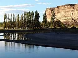
The Chubut River is located in the Patagonia region of southern Argentina. Its name comes from the Tehuelche word chupat, which means "transparent". The Argentine Chubut Province, through which the river flows, is named after it. Welsh settlers called the river "Afon Camwy", meaning "twisting river".

National Route 40, also known as RN40 or "Ruta 40", is a route in western Argentina, stretching from Cabo Vírgenes near Río Gallegos in Santa Cruz Province in the south to La Quiaca in Jujuy Province in the north with approximately 5194 km length. The route parallels the Andes mountains. The southern part of the route, by now largely paved, has become a well-known adventure tourism journey, and there are plans to pave the whole road.

The Tehuelche people, also called the Aónikenk, are an indigenous people from eastern Patagonia in South America. In the 18th and 19th centuries the Tehuelche were influenced by Mapuche people, and many adopted a horseriding lifestyle. Once a nomadic people, the lands of the Tehuelche were colonized in the 19th century by Argentina and Chile, gradually disrupting their traditional economies. The establishment of large sheep farming estates in Patagonia was particularly detrimental to the Tehuelche. Contact with outsiders also brought in infectious diseases ushering deadly epidemics among Tehuelche tribes. Most existing members of the group currently reside in cities and towns of Argentine Patagonia.
Junín de los Andes is a first category municipality and administrative center of the Huiliches Department in the province of Neuquén, Argentina. It is located in the south of the province, by the Chimehuin River, on National Route 234, about 35 km (22 mi) north of San Martín de los Andes and 17 km (11 mi) from the Chapelco Airport, which services the area.
Tecka is a town in Chubut Province, Argentina, located 100 kilometres (62 mi) south of Esquel and around 500 kilometres (310 mi) west of Rawson along National Route 25. It is the seat of the Languiñeo Department.
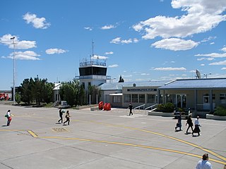
El Tehuelche Airport is an airport 5 kilometres (3 mi) northwest of Puerto Madryn, a city on Golfo Nuevo in the Chubut Province of Argentina. The airport is 5 kilometres (3 mi) inland from the gulf, on the 3-RN Acceso Norte Puerto Madryn (U9120).
The Pico River is a binational river of Patagonian Argentina and Chile. It is a tributary of the Figueroa River which it enters near El Manzanito in Chile. The Pico Rivers arises at the confluence of the Río Tromencó and the Río de las Mulas in Tehuelches Department, Chubut Province, Argentina, about 5.5 kilometres (3.4 mi) east-southeast of the village of Río Pico and about 40 kilometres (25 mi) east of the Chilean border. The river was named in honour of the engineer Octavio Pico y Burgess (1837–1892), who headed the Boundary Commission that settled the border conflict between Argentina and Chile.

Villa Dique Florentino Ameghino is a rural commune in Chubut Province in southern Argentina. It is located next to the Florentino Ameghino Dam on the Chubut River, 140 kilometres (87 mi) to the west of the city of Trelew. The town had 224 residents as of the 2001 census, an 18.5% increase from the previous (1991) census, when it had 189 residents.
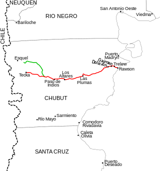
National Route 25 is a 534-kilometer-long paved highway that runs through the center of Chubut Province, Argentina. It extends from the juncture with National Route 40 in Tecka to the bridge on the Chubut River in the city of Rawson. The highway crosses the Patagonian Steppe, joining sparsely populated areas.
Los Altares Valley, also called Las Ruinas Valley is a valley in central Chubut Province in southern Argentina. It is accessed via National Route 25.
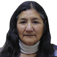
Rosa Laudelina Chiquichano Nahuelquir is an Argentine lawyer and politician of Tehuelche-Mapuche descent who served as Deputy for the province of Chubut between 2007 and 2011. When assuming the position, she became the first member of the Tehuelche people to take a seat in the National Congress.