Y Wladfa, also occasionally Y Wladychfa Gymreig, refers to the establishment of settlements by Welsh immigrants in Patagonia, beginning in 1865, mainly along the coast of the lower Chubut Valley. In 1881, the area became part of the Chubut National Territory of Argentina which, in 1955, became Chubut Province.

Chubut is a province in southern Argentina, situated between the 42nd parallel south, the 46th parallel south, the Andes range to the west, and the Atlantic ocean to the east. The province's name derives from the Tehuelche word chupat, meaning "transparent," their description of the Chubut River.

National Route 40, also known as RN40 or "Ruta 40", is a route in western Argentina, stretching from Punta Loyola near Rio Gallegos in Santa Cruz Province in the south to La Quiaca in Jujuy Province in the north. The route parallels the Andes mountains. The southern part of the route, by now largely paved, has become a well-known adventure tourism journey, and there are plans to pave the whole road.

Ruta Nacional 3 is an Argentine highway, stretching from the eastern side of the country in Buenos Aires, crossing the provinces of Buenos Aires, Río Negro, Chubut Province, Santa Cruz and Tierra del Fuego. Since its start at Avenida General Paz (A001) until the end, on the bridge over Lapataia River, it measures 3,045 kilometres (1,892 mi).

National Route 9 is a major road in Argentina, which runs from the center-east to the northwest of the country, crossing the provinces of Buenos Aires, Santa Fe, Córdoba, Santiago del Estero, Tucumán, Salta and Jujuy. It starts on Avenida General Paz, which marks the border between the Autonomous City of Buenos Aires and the surrounding province of the same name, and ends at the Horacio Guzmán International Bridge, on the La Quiaca River, traversing 1,967 km (1,222 mi). The road is a limited access motorway from Buenos Aires to Rosario.
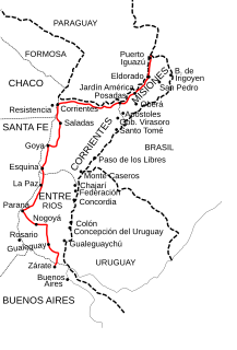
National Route 12 (RN12) is a road in Argentina, connecting the northeast section to the rest of the country. It runs through the provinces of Misiones, Corrientes, Entre Ríos and Buenos Aires.
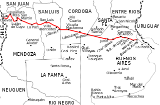
National Route 7 is a road in Argentina. It crosses the country from east to west, from the capital to the border with Chile, thus linking the Atlantic coast with the Andes, crossing the provinces of Buenos Aires, Santa Fe, Córdoba, San Luis and Mendoza. It has a total length of 1,224 km (761 mi), of which 367 km (228 mi) (30%) are freeways.
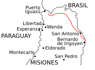
National Route 101 is a national road in the NW of Misiones Province, Argentina ending at Iguazu National Park. It runs for 145 km (90 mi) near the border between Argentina and Brazil crossing the Missiones Province Departments of General Manuel Belgrano and Iguazú.
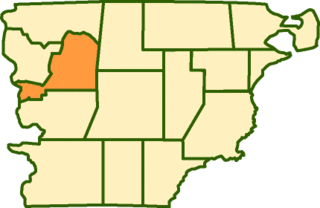
Languiñeo Department is a department of Chubut Province in Argentina.

In the last years of the 1950s, it became clear that there was a need to modernize the old Suspension bridges road in the province of Córdoba, Argentina. Increasing traffic and trade between the provinces of Cordoba Mendoza and San Juan needed new roads to expedite travelling times and decrease costs. At the same time, it was considered important to create a route linking the ports of the Atlantic with the Pacific through the Cordoba corridor.

National Route 1, also known as Buenos Aires–La Plata Highway and officially called Autopista Doctor Ricardo Balbín since 2004, is a highway that connects the 25 de Mayo Highway and Paseo del Bajo in the city of Buenos Aires with the Provincial Route 11, near the city of La Plata. It has a length of 50 km (31 mi) with two or four lanes on each direction in different areas, and is indicated in red in the map.

Autovía 2 Juan Manuel Fangio is an Argentine dual carriageway, which runs from Buenos Aires to Mar del Plata. The road was a National Route until 1990 when it was transferred to the Government of Buenos Aires Province. The Autovía 2 extends from the junction of Provincial Routes 1 and 36 and National Route A004, just on the traffic circle "Juan María Gutiérrez", which is the limit of Berazategui and Florencio Varela districts.
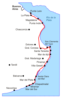
Provincial Route 11 is a 583-kilometre-long (362 mi) Argentine road in the East of Buenos Aires Province. The road extends from Punta Lara to the town of Mar del Sur.

Provincial Route 63 is a 29-kilometre-long (18 mi) Argentine road in the East of Buenos Aires Province. The road extends from Dolores, Buenos Aires to the "Esquina de Crotto", a paraje in Tordillo Partido.

National Route 8 is a highway located in Argentina, that connects the provinces of Buenos Aires, Santa Fe, Córdoba and San Luis. The route starts at the link with National Route 9 in the northwest of Greater Buenos Aires, between the towns of El Talar, El Triángulo, Ricardo Rojas and Ingeniero Pablo Nogués, to the link with Provincial Route 55 in Villa Mercedes, San Luis Province at 695 km (432 mi).
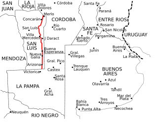
Provincial Route 55 is a 458 km (285 mi) long paved highway that runs through San Luis Province, from north to south at the eastern end, near the border with the provinces of Córdoba and La Pampa.

National Route 148 is a short highway located in the central region of Argentina. It has an approximate extension of 40 km that run in a north–south direction.
Provincial Route 105 is a highway located in the Argentine province of La Pampa. Its total route is 180 km, being partially asphalt.

Provincial Route 10 is a highway located in the Argentine province of La Pampa. Its total route is 440 km (273 mi) completely of asphalt to Santa Isabel.

Provincial Route 1 is a 21 km (13 mi) long paved highway located in the partidos of La Plata and Berazategui in the province of Buenos Aires, in Argentina. From its beginning to the Cruce Gutiérrez, the route is part of the Camino General Belgrano, a road paved between 1912 and 1916, which is a narrow road with one lane in each direction. The rest of the route belongs to Camino Centenario.


