
Rosario is the largest city in the central Argentina province of Santa Fe. The city is located 300 km (186 mi) northwest of Buenos Aires, on the west bank of the Paraná River. Rosario is the third-most populous city in the country, and is also the most populous city in Argentina that is not a capital. With a growing and important metropolitan area, Greater Rosario has an estimated population of 1,750,000 as of 2020. One of its main attractions includes the neoclassical, Art Nouveau, and Art Deco architecture that has been retained over the centuries in hundreds of residences, houses and public buildings.

Santa Fe de la Vera Cruz is the capital city of the province of Santa Fe, Argentina. It is situated in north-eastern Argentina, near the junction of the Paraná and Salado rivers. It lies 15 kilometres (9.3 mi) from the Hernandarias Subfluvial Tunnel that connects it to the city of Paraná. The city is also connected by canal with the port of Colastiné on the Paraná River. Santa Fe de la Vera Cruz has about 391,164 inhabitants per the 2010 census [INDEC]. The metropolitan area has a population of 653,073, making it the eighth largest in Argentina. The third largest city in Argentina is Rosario, also located in Santa Fe Province. Rosario has a population of 1.24 million and it is the largest city in Argentina not to be a provincial capital.

Greater Rosario is the metropolitan area of the city of Rosario, in the province of Santa Fe, Argentina. This metropolis has a population of about 1.3 million thus being Argentina's third most populated urban settlement, after Buenos Aires and Córdoba.

San Lorenzo is a city in the south of the Province of Santa Fe, Argentina, located 23 km north of Rosario, on the western shore of the Paraná River, and forming one end of the Greater Rosario metropolitan area. It is the head town of the San Lorenzo Department, and it has about 46,000 inhabitants according to the 2010 census [INDEC].
Roldán is a small city in the province of Santa Fe, Argentina, located within the metropolitan area of Greater Rosario. According to the 2001 census, it had a population of 11,470 inhabitants. Its area is 114 km².

National Route 40, also known as RN40 or "Ruta 40", is a route in western Argentina, stretching from Punta Loyola near Rio Gallegos in Santa Cruz Province in the south to La Quiaca in Jujuy Province in the north. The route parallels the Andes mountains. The southern part of the route, by now largely paved, has become a well-known adventure tourism journey, and there are plans to pave the whole road.

National Route 9 is a major road in Argentina, which runs from the center-east to the northwest of the country, crossing the provinces of Buenos Aires, Santa Fe, Córdoba, Santiago del Estero, Tucumán, Salta and Jujuy. It starts on Avenida General Paz, which marks the border between the Autonomous City of Buenos Aires and the surrounding province of the same name, and ends at the Horacio Guzmán International Bridge, on the La Quiaca River, traversing 1,967 km (1,222 mi). The road is a limited access motorway from Buenos Aires to Rosario.

Sunchales is a city in the province of Santa Fe, Argentina. It has 21,304 inhabitants per the 2010 census [INDEC]. It lies in the center-west of the province, 135 km (84 mi) from the provincial capital Santa Fe, on National Route 34.

San Martín Street is an important street in Rosario, Santa Fe Province, Argentina. It runs north–south through the center of the city, from the coastal avenue by the Paraná River to the southern limit of the urbanized area. It was originally named Calle del Puerto ; the name was changed in 1887 to honour Independence War hero General José de San Martín.
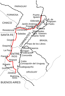
National Route 12 (RN12) is a road in Argentina, connecting the northeast section to the rest of the country. It runs through the provinces of Misiones, Corrientes, Entre Ríos and Buenos Aires.
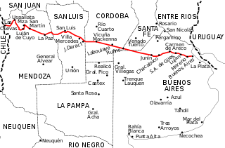
National Route 7 is a road in Argentina. It crosses the country from east to west, from the capital to the border with Chile, thus linking the Atlantic coast with the Andes, crossing the provinces of Buenos Aires, Santa Fe, Córdoba, San Luis and Mendoza. It has a total length of 1,224 km (761 mi), of which 367 km (228 mi) (30%) are freeways.

Rondeau Boulevard is a two-way, four-lane avenue and arterial road in Rosario, province of Santa Fe, Argentina. It starts as a continuation of Alberdi Avenue, in Barrio Lisandro de la Torre, and runs in a straight line, roughly parallel to the Paraná River, along the center of the northeastern block of the city, forming the western limit of Barrio Alberdi. It ends in the node formed by Beltway Avenue, the access to the Rosario-Victoria Bridge and the beginning of National Route 11, which marks the municipal border of Rosario with the city of Granadero Baigorria.

The General Manuel Belgrano Railway (FCGMB), named after the Argentine politician and military leader Manuel Belgrano, is a 1,000 mmmetre gauge railway and the longest of the Argentine system. It was one of the six State-owned Argentine railway companies formed after President Juan Perón's nationalisation of the railway network in 1948.

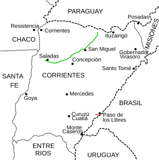
National Route 118 is a national road in Argentina, in the northwest of Corrientes Province. It starts at the junction with National Route 12 until reaching the rural area of Paraje Vallejos Cué for a total length of 196 kilometres (122 mi). The road is marked in red in the map.
National Route 117 is a national road in Argentina, in Paso de los Libres Department in the SE of Corrientes Province. From its start in km marker 496 of National Route 14 until its end at the Paso de los Libres-Uruguaiana International Bridge unites the cities of Paso de los Libres, Argentina and Uruguaiana, Brazil for a total length of 12.9 kilometres (8 mi). The road is marked in red in the map.
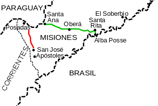
National Route 105 is a national road in the SW of Misiones Province, Argentina. From its start National Route 12 in Villalonga outside of the capital city of Posadas until its end at National Route 14, it has a total length of 35 kilometres (22 mi). The road is marked in red in the map.

National Route A008 is a 30 km (18.6 mi) beltway highway for the city of Rosario, Argentina. Built for traffic to avoid the congested city center, it allows drivers to bypass the city going around it in a much shorter time.
National Route A010 is a highway in the northeast of Chubut Province, Argentina. It has a length of 6.5 km (4.0 mi) joining National Route 3 at its km marker 1,395, with the city of Puerto Madryn, in Biedma Department.
There are 34 routes assigned to the "S" zone of the California Route Marker Program, which designates county routes in California. The "S" zone includes county highways in Imperial, Orange, Riverside, San Diego, and Santa Barbara counties.
Road signs in Argentina are similar to those of other South American countries. They are something of a compromise between the Vienna Convention signs used in Europe and the U.S. system. Argentina is right-hand traffic.
