
State Route 74, part of which forms the Palms to Pines Scenic Byway or Pines to Palms Highway, and the Ortega Highway, is a state highway in the U.S. state of California. It runs from Interstate 5 in San Juan Capistrano in Orange County to the city limits of Palm Desert in Riverside County. Stretching about 111 miles (179 km), it passes through several parks and National Forests between the Pacific coast and the Coachella Valley.

Tibás is the thirteenth canton in the province of San José in Costa Rica. The head city of the canton is San Juan.

San Antonio Missions National Historical Park is a National Historical Park and part of a UNESCO World Heritage Site preserving four of the five Spanish frontier missions in San Antonio, Texas, USA. These outposts were established by Catholic religious orders to spread Christianity among the local natives. These missions formed part of a colonization system that stretched across the Spanish Southwest in the 17th, 18th, and 19th centuries.

Colonel Bonny Serrano Avenue, formerly called and still referred to as Santolan Road, is a major east–west thoroughfare in the Eastern Manila District of Metro Manila, Philippines, running between San Juan and Quezon City. It forms the northern limit of San Juan and the southern limit of Quezon City's New Manila and Cubao districts and links the Philippine National Police headquarters in Camp Crame with the Armed Forces of the Philippines headquarters in Camp Aguinaldo. The avenue runs from the border of barangays Corazon de Jesus, St. Joseph, and Little Baguio in San Juan in the west to barangays Libis and Blue Ridge B near Quezon City's border with Marikina in the east. It was named after the decorated Korean War hero, Venancio "Bonny" Serrano.
San Juan is a district of the Naranjo canton, in the Alajuela province of Costa Rica.
National Border Route 1856, whose official name is Ruta Juan Rafael Mora Porras, and is also known as trocha fronteriza, is an abandoned dirt road in Costa Rica on the south bank of the San Juan River.
National Primary Route 1, formally known as Carretera Interamericana Norte, is the northern segment of the Pan-American Highway that traverses Costa Rica.
National Primary Route 5, or just Route 5 is a National Road Route of Costa Rica, and it is a road from the area known as Tournón, in the triple limit of the Cinco Esquinas, Tibás district, Merced, San José district, and San Francisco, Goicoechea district in San José province to the Heredia district in the Heredia province of Costa Rica, and joins Route 108 and Route 3.
National Secondary Route 101, or just Route 101 is a National Road Route of Costa Rica, located in the San José province.
National Secondary Route 102, or just Route 102 is a National Road Route of Costa Rica, located in the San José province.
National Secondary Route 107, or just Route 107 is a National Road Route of Costa Rica, located in the Alajuela province.
National Secondary Route 117, or just Route 117 is a National Road Route of Costa Rica, located in the San José, Heredia provinces.
National Secondary Route 123, or just Route 123 is a National Road Route of Costa Rica, located in the Alajuela, Heredia provinces.
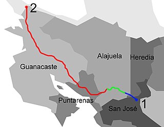
National Secondary Route 131, or just Route 131 is a National Road Route of Costa Rica, located in the Alajuela, Puntarenas provinces.
National Secondary Route 137, or just Route 137 is a National Road Route of Costa Rica, located in the San José, Alajuela provinces.
National Secondary Route 251, or just Route 251 is a National Road Route of Costa Rica, located in the San José, Cartago provinces.
National Secondary Route 217, or just Route 217 is a National Road Route of Costa Rica, located in the San José province.
National Tertiary Route 319, or just Route 319 is a National Road Route of Costa Rica, located in the San José province.
National Tertiary Route 703, or just Route 703 is a National Road Route of Costa Rica, located in the Alajuela province.
National Tertiary Route 704, or just Route 704 is a National Road Route of Costa Rica, located in the Alajuela province.