Related Research Articles

The province of Ciudad Real is a province in the southwestern part of the autonomous community of Castile-La Mancha, Spain. It is bordered by the provinces of Cuenca, Albacete, Jaén, Córdoba, Badajoz, and Toledo. It is partly located in the old natural region of La Mancha. Its capital is Ciudad Real. It is the third largest province by area in all of Spain, after Cáceres and Badajoz. The historic comarca Campo de Calatrava is located in the center of the province.

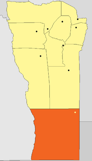
Río Negro is a province of Argentina, located at the northern edge of Patagonia. Neighboring provinces are from the south clockwise Chubut, Neuquén, Mendoza, La Pampa and Buenos Aires. To the east lies the Atlantic Ocean.

La Pampa is a sparsely populated province of Argentina, located in the Pampas in the center of the country. Neighboring provinces are from the north clockwise San Luis, Córdoba, Buenos Aires, Río Negro, Neuquén and Mendoza.

Santa Rosa is a city in the Argentine Pampas (lowlands), and the capital of La Pampa Province, Argentina. It lies on the east of the province, on the shore of the Don Tomás Lagoon, at the intersection of National Routes 5 and 35. The city (94,340) and its surroundings hold 102,610 inhabitants ,Census-ar 2.010 hold 124.101 inhabitants the capital y Toay around a third of the population of the province. Its current mayor is Leandro Altolaguirre. Founded in 1892 by Tomás Mason, Santa Rosa did not develop into a relatively important agricultural centre until the second half of the 20th century. It is still one of the smallest provincial capitals of the country after Patagonian Rawson, Ushuaia and Viedma.
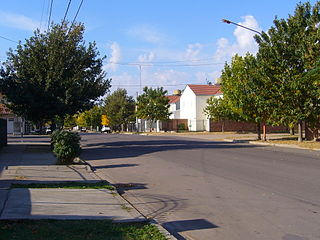
General Pico is a city located in the northeast of La Pampa Province, Argentina. It is located at 143 m (469 ft) above sea level and inside the region of the Pampa Húmeda Llana. It has a surface area of 2,555 km2 (986 sq mi).
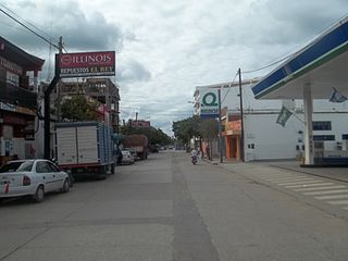
San Ramón de la Nueva Orán is a city in northwest province of Salta, Argentina, about 270 km (170 mi) from the provincial capital, Salta. It is the head town of the Orán Department, and it has about 73,000 inhabitants as per the 2001 census [INDEC], which makes it the second-most populated in the province.

National Route 40, also known as RN40 or "Ruta 40", is a route in western Argentina, stretching from Punta Loyola near Rio Gallegos in Santa Cruz Province in the south to La Quiaca in Jujuy Province in the north. The route parallels the Andes mountains. The southern part of the route, by now largely paved, has become a well-known adventure tourism journey, and there are plans to pave the whole road.

National Route 9 is a major road in Argentina, which runs from the center-east to the northwest of the country, crossing the provinces of Buenos Aires, Santa Fe, Córdoba, Santiago del Estero, Tucumán, Salta and Jujuy. It starts on Avenida General Paz, which marks the border between the Autonomous City of Buenos Aires and the surrounding province of the same name, and ends at the Horacio Guzmán International Bridge, on the La Quiaca River, traversing 1,967 km (1,222 mi). The road is a limited access motorway from Buenos Aires to Rosario.
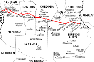
National Route 7 is a road in Argentina. It crosses the country from east to west, from the capital to the border with Chile, thus linking the Atlantic coast with the Andes, crossing the provinces of Buenos Aires, Santa Fe, Córdoba, San Luis and Mendoza. It has a total length of 1,224 km (761 mi), of which 367 km (228 mi) (30%) are freeways.
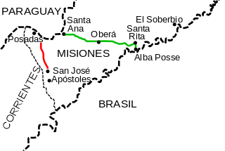
National Route 105 is a national road in the SW of Misiones Province, Argentina. From its start National Route 12 in Villalonga outside of the capital city of Posadas until its end at National Route 14, it has a total length of 35 kilometres (22 mi). The road is marked in red in the map.

The Province of Buenos Aires Railway was a state-owned company that operated a 902 km 1,000 mmmetre gauge railway network in the Province of Buenos Aires in Argentina. Founded in 1907 as the "Ferrocarril Provincial del Puerto de La Plata al Meridiano V", the company changed its name to FCPBA in 1924, in 1951 it was taken into state ownership and in 1953 it was absorbed by the state-owned Belgrano Railway. The FCPBA should not confused with the similarly named French–owned Compañía General (CGBA) which also operated in the Province.

Merced is a district of the San José canton, in the San José province of Costa Rica. It is one of the four administrative units that form San José downtown properly. This division is merely commercial, but covers an important part of "josefino" life and activities.

Pampa de Achala is the name given to a vast region that lies at the heart of the Sierras de Córdoba located within Sierras Pampeanas, and located in central-northwest of Argentina. It is a rugged area with little vegetation, lying over 1,500 m above sea level, and which has distinctive species, ecology, relief and hydrography. The region is protected by provincial law, and that this region basin is head of the vast majority of streams that run through the Córdoba.

National Route 1, also known as Buenos Aires–La Plata Highway and officially called Autopista Doctor Ricardo Balbín since 2004, is a highway that connects the 25 de Mayo Highway and Paseo del Bajo in the city of Buenos Aires with the Provincial Route 11, near the city of La Plata. It has a length of 50 km (31 mi) with two or four lanes on each direction in different areas, and is indicated in red in the map.

Puelches is a village and rural locality (municipality) lying on the National Route 152 in La Pampa Province in Argentina. It serves as the administrative center of the Curacó Department with its rural area expanding into the Lihuel Calel Department in the south of the province.

National Route 25 is a 534-kilometer-long paved highway that runs through the center of Chubut Province, Argentina. It extends from the juncture with National Route 40 in Tecka to the bridge on the Chubut River in the city of Rawson. The highway crosses the Patagonian Steppe, joining sparsely populated areas.
Gobernador Dupuy is a department of San Luis Province, Argentina.
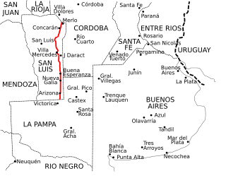
Provincial Route 55 is a 458 km (285 mi) long paved highway that runs through San Luis Province, from north to south at the eastern end, near the border with the provinces of Córdoba and La Pampa.

National Route 148 is a short highway located in the central region of Argentina. It has an approximate extension of 40 km that run in a north–south direction.

Provincial Route 10 is a highway located in the Argentine province of La Pampa. Its total route is 440 km (273 mi) completely of asphalt to Santa Isabel.
References
- ↑ Policía de La Pampa. Mapa de Rutas
- ↑ "Mapa de la red". Archived from the original on 13 March 2016. Retrieved 11 April 2013.
- ↑ Caminos de la red nacional. Dirección Nacional de Vialidad. Buenos Aires: J. Pesce. 1936. p. 99.
| National |
| ||||||||||
|---|---|---|---|---|---|---|---|---|---|---|---|
| Provincial |
| ||||||||||