A frontage road is a local road running parallel to a higher-speed, limited-access road. A frontage road is often used to provide access to private driveways, shops, houses, industries or farms. Where parallel high-speed roads are provided as part of a major highway, these are also known as local-express lanes.

Belgrano is a northern and leafy barrio or neighborhood of Buenos Aires, Argentina.

Núñez is a barrio or neighbourhood of Buenos Aires, Argentina. It is on the northern edge of the city on the banks of the Rio de la Plata. The barrio of Belgrano is to the southeast; Saavedra and Coghlan are to the west; and Vicente López, in Buenos Aires Province, is to the north.

July 9 Avenue is a major thoroughfare in the city centre of Buenos Aires, Argentina. Its name honors Argentina's Independence Day, July 9, 1816.

Retiro is a barrio or neighborhood in Buenos Aires, Argentina. Located in the northeast end of the city, Retiro is bordered on the south by the Puerto Madero and San Nicolás, and on the west by the Recoleta.

Liniers is a barrio (neighborhood) of Buenos Aires on the edge of the city, centered on Rivadavia Avenue. It is also an important train station and bus hub, connecting western Gran Buenos Aires with the Buenos Aires Metro.

National Route 9 is a major road in Argentina, which runs from the center-east to the northwest of the country, crossing the provinces of Buenos Aires, Santa Fe, Córdoba, Santiago del Estero, Tucumán, Salta and Jujuy. It starts on Avenida General Paz, which marks the border between the Autonomous City of Buenos Aires and the surrounding province of the same name, and ends at the Horacio Guzmán International Bridge, on the La Quiaca River, traversing 1,967 km (1,222 mi). The road is a limited access motorway from Buenos Aires to Rosario.

Ciudadela is a city in Greater Buenos Aires, Buenos Aires Province, Argentina. It is located in the Tres de Febrero Partido, immediately to the west of the neighborhood of Liniers in Buenos Aires city proper. It is separated from the city by General Paz avenue.
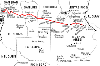
National Route 7 is a road in Argentina. It crosses the country from east to west, from the capital to the border with Chile, thus linking the Atlantic coast with the Andes, crossing the provinces of Buenos Aires, Santa Fe, Córdoba, San Luis and Mendoza. It has a total length of 1,224 km (761 mi), of which 367 km (228 mi) (30%) are freeways.
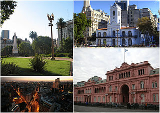
Monserrat in the simplified Spanish spelling or, originally, Montserrat is a neighbourhood in the east of the Buenos Aires CBD. The district features some of the most important public buildings in Buenos Aires, including city hall, the city legislature, Casa Rosada, the Colegio Nacional de Buenos Aires and the Libertador Building, among others.

Villa Lugano is a neighbourhood in Buenos Aires, Argentina, located in the south of the city. It has a population of approximately 114,000 people.

Avenida Rivadavia is one of the principal thoroughfares in Buenos Aires, Argentina, extending 23 miles (37 km) from downtown Buenos Aires to the western suburb of Merlo.
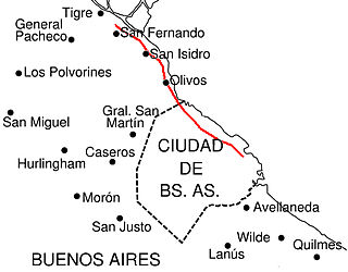
Avenida del Libertador is one of the principal thoroughfares in Buenos Aires, Argentina, and in points north, extending 25 km (16 mi) from the Retiro District of Buenos Aires to the northern suburb of San Fernando.

Avenida Santa Fe is one of the principal thoroughfares in Buenos Aires, Argentina. The artery is essential to the imaginary axis of Barrio Norte in Buenos Aires, comprising the areas influenced by the route of the avenue through Retiro, Recoleta and Palermo neighborhoods, it is considered one of the main shopping and strolling areas of the city, its many boutiques range from elegant to edgy, which has led it to be dubbed the 'Avenue of Fashion'. Upscale Alto Palermo, at Avenida Coronel Díaz, is one of the city's best-known vertical malls. Avenida Santa Fe is also an attraction for its architecture, strongly reminiscent of Paris. Its name pays homage to the eponymous province in Argentina.
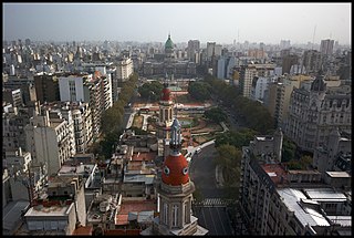
Congressional Plaza is a public park facing the Argentine Congress in Buenos Aires. The plaza is part of a 3 hectare open space comprising three adjoining plazas to the east of the Congress building. The Kilometre Zero for all Argentine National Highways is marked on a milestone at the Plaza.

Avenida Leandro N. Alem is one of the principal thoroughfares in Buenos Aires, Argentina, and a commercial nerve center of the city's San Nicolás and Retiro districts.

The Buenos Aires Metrobus is a 50.5 km (31.4 mi) network of dedicated separated lanes and stations for normal buses that serve the city of Buenos Aires, Argentina. Designed as a Bus Rapid Transit system, it mixes a few bi-articulated buses with conventional buses. The headway is the same as before the implementation of the system, and it lacks the brand of the network in the buses that use it, maintaining their previous branding as common bus lines with their own numbers. The service operates 24 hours a day and 365 days a year, with 2-4 minute frequencies during the day and 10–15 minutes at night.

Autovía 2 Juan Manuel Fangio is an Argentine dual carriageway, which runs from Buenos Aires to Mar del Plata. The road was a National Route until 1990 when it was transferred to the Government of Buenos Aires Province. The Autovía 2 extends from the junction of Provincial Routes 1 and 36 and National Route A004, just on the traffic circle "Juan María Gutiérrez", which is the limit of Berazategui and Florencio Varela districts.
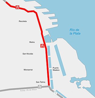
Paseo del Bajo, officially named Brigadier General Juan Manuel de Rosas, is a highway in the city of Buenos Aires, Argentina. It joins the 25 de Mayo, Arturo Illia and Buenos Aires-La Plata highways. It has a length of 7.1 km (4 mi) with two lanes on each direction.

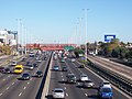
Avenida Leopoldo Lugones, and its southern continuation, Autopista Dr. Arturo Umberto Illia, is a freeway running from Avenida General Paz in the north, which continues to an interchange with National Route 9 and the Paseo del Bajo in the city center. It provides access to Downtown Buenos Aires from the northern suburbs, and from Rosario, Cordoba, and other northern destinations. Due to the lack of a complete bypass of the city, it also connects truck and bus traffic from La Plata to the north. It runs along the east shore of the city, providing access to Aeroparque Jorge Newbery.