Belgrano, Buenos Aires

Last updated
Belgrano
Belgrano montage.jpg
Clockwise from top: Chinese New Year celebrations in Chinatown, Barrancas de Belgrano, a typical residential street in Belgrano R and River Plate Stadium.
Emblema Belgrano.png
Belgrano, Buenos Aires
Location of Belgrano within Buenos Aires
Country Argentina
Autonomous City Buenos Aires
Comuna C13
Government
  PresidentFlorencia Scavino (PRO-JxC)
Area
  Total6.8 km2 (2.6 sq mi)
Population
 (2001)
  Total138,942
  Density20,000/km2 (53,000/sq mi)
Time zone UTC-3 (ART)

Belgrano is a northern and leafy barrio or neighborhood of Buenos Aires, Argentina.

Contents

Location

The barrio of Palermo is to the southeast; Núñez is to the northwest; Coghlan, Villa Urquiza, Villa Ortúzar and Colegiales are to the southwest.

History

Washerwomen in Bajo Belgrano, painting by Prilidiano Pueyrredon, 1865 Prilidiano Pueyrredon - Lavanderas en el bajo de Belgrano - Google Art Project.jpg
Washerwomen in Bajo Belgrano, painting by Prilidiano Pueyrredón, 1865

Belgrano was named after Manuel Belgrano, a politician and military leader who created the national flag of Argentina. In 1820, at Belgrano's death, Buenos Aires' legislature introduced a law to name the next town to be founded after him. This happened in 1855, when the Buenos Aires government, fearful that relatives of Juan Manuel de Rosas would dispute the governmental decision to expropriate Rosas' lands, laid down a new town on part of it and named it Belgrano. The town was declared a city shortly thereafter, due to its booming growth, and in 1880 it became the nation's capital for a few weeks, because of the dispute between the national government and Buenos Aires province for the status of the city of Buenos Aires. It was in Belgrano that the law declaring Buenos Aires as Argentina's federal capital was issued.

Alberti Sq. Buenos Aires -- Estatua Manuel Maximo Alberti.jpg
Alberti Sq.

In 1887, the federal district was enlarged by the annexation of the towns (partidos) of Belgrano and Flores.

Subsections

The front of Universidad de Belgrano UniversidaddeBelgrano.JPG
The front of Universidad de Belgrano

Belgrano is an upper-middle-class neighborhood that can be roughly divided into Belgrano R, Belgrano C, central Belgrano, and Lower Belgrano (Bajo Belgrano). The heart of the barrio pulses with life on its main thoroughfare, Avenida Cabildo, which runs Northwest to Southeast; the subway (subte) Line D follows its route.

Avenida Cabildo carries heavy automobile traffic, and features corner cafés, grocery stores, movie theaters, specialty shops, clothing boutiques, bookstores, and other retail venues. Thanks to its wide sidewalks, pedestrians are especially numerous on weekend afternoons as Porteños (residents of Buenos Aires) from various areas of the city come to shop.

Most of the neighborhood's densest housing is located in the vicinity of Cabildo. High-rise luxury apartment buildings are clustered on the leafy streets surrounding the Universidad de Belgrano, a private liberal-arts university.

Many older single-family homes have been replaced by high-rise residential structures in the denser sections of Belgrano. Casaentretorres.JPG
Many older single-family homes have been replaced by high-rise residential structures in the denser sections of Belgrano.

West of Crámer avenue, "Belgrano R" is chiefly residential and lower-density in nature, characterized by calm streets lined with large, mature shade trees. Most buildings in this section are detached single-family homes that follow North American architectural styles; some residences have sizable backyards with swimming pools. This section is favored by wealthy Argentines and expatriate businesspeople, and also by the embassies of Egypt, Japan, Republic of Korea, Tunisia, United Arab Emitates, among others. Some expensive private, bilingual schools are located in the area.

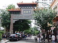
"Belgrano C" is also home to Buenos Aires's small Chinatown. The district is crowded with restaurants and specialty grocery stores catering to Asian-Argentines and to the general public.

Transportation

Other than Cabildo, avenues Libertador, Luis Maria Campos, Crámer, Ricardo Balbín (formerly known as del Tejar), and Figueroa Alcorta run parallel to the riverbank, while Federico Lacroze, Juramento, Monroe and Congreso run from the riverbank to the Southwest direction. Belgrano is served by the Buenos Aires metro line D, many bus lines (notably Colectivo 60), and two commuter rail lines. Approximately 1.5 km to the west of Belgrano lies Avenida General Paz, a major limited-access freeway that defines the city limits of Buenos Aires proper. Beyond this avenue lie the suburbs of Vicente Lopez, Florida and Olivos.

Highrise apartment buildings overlooking Barrancas de Belgrano Torresbarrancasdebelgrano.JPG
Highrise apartment buildings overlooking Barrancas de Belgrano

Notable attractions

The lush park Barrancas de Belgrano was designed by the famous French-Argentine landscape/park architect Carlos Thays, who designed many open spaces throughout Buenos Aires. Several blocks north of the Belgrano University, Barrancas de Belgrano spans several city blocks and is overlooked by highrise upper-middle class apartment buildings.

On Manuel Belgrano square, a local artisan fair is held regularly, and becomes especially vibrant on weekends. It features a small bust of Manuel Belgrano on its middle spot.

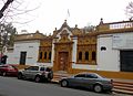
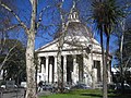
In the edge of the plaza lies the Inmaculada Concepción church, called "La Redonda" (the round one) by locals because of its circular plan. Many weddings are celebrated in this church in the afternoon hours. Two museums are also across Juramento and Cuba streets: Larreta and Sarmiento, respectively. Larreta museum focus on Spanish art. It is located on the former private residence of writer Enrique Larreta, designed by architect Ernesto Bunge on 1882. It features a well kept Andalusian garden. Historical Museum Sarmiento exhibits some objects belonging to former presidents Domingo Faustino Sarmiento and Nicolás Avellaneda. It is located in what used to be Belgrano townhall, where the national congress held its sessions while Belgrano was the capital of the Argentine republic. Nearby, going down to Lower Belgrano (Bajo Belgrano), appears the Barrancas de Belgrano, three squares along together, older Rio de la Plata River natural terraces. Two blocks away, in Lower Bergrano there is the Estadio de Excursionistas, the local football team. Although neighboring Nuñez is widely known as the home of River Plate, its landmark stadium River Plate Stadium—also home of the Argentina national football team—is located within the boundaries of Belgrano.

River Plate Stadium River Monumental Panoramic.jpg
Panorama view of Belgrano Barrio Belgrano.jpg
Panorama view of Belgrano

Related Research Articles

<span class="mw-page-title-main">Plaza de Mayo</span> Public square in Buenos Aires, Argentina

The Plaza de Mayo is a city square and the main foundational site of Buenos Aires, Argentina. It was formed in 1884 after the demolition of the Recova building, unifying the city's Plaza Mayor and Plaza de Armas, by that time known as Plaza de la Victoria and Plaza 25 de Mayo, respectively. The city centre of Buenos Aires, Plaza de Mayo has been the scene of the most momentous events in Argentine history, as well as the largest popular demonstrations in the country. On the occasion of the first anniversary of the May Revolution in 1811, the Pirámide de Mayo was inaugurated in the square's hub, becoming Buenos Aires' first national monument.

<span class="mw-page-title-main">Palermo, Buenos Aires</span> Neighborhood of Buenos Aires in C14, Argentina

Palermo is a barrio or neighborhood of Buenos Aires, Argentina. It is located in the north of the city, near the Rio de la Plata.

<span class="mw-page-title-main">Núñez, Buenos Aires</span> Neighborhood in C13, Buenos Aires, Argentina

Núñez is a barrio or neighbourhood of Buenos Aires, Argentina. It is on the northern edge of the city on the banks of the Rio de la Plata. The barrio of Belgrano is to the southeast; Saavedra and Coghlan are to the west; and Vicente López, in Buenos Aires Province, is to the north.

<span class="mw-page-title-main">Colectivo 60</span> Bus line in Buenos Aires, Argentina

The Colectivo 60 commenced operations in 1931 and runs from Constitución station, in the centre of the city of Buenos Aires, Argentina to the Tigre Club in the partido of Tigre. The service is operated by Transportes Larrazabal C.I.S.A, DOTA and MOTSA and the identifying colour of the buses is white and red with black details.

<span class="mw-page-title-main">Neighbourhoods of Buenos Aires</span> List of official districts of Buenos Aires

Buenos Aires, autonomous city and capital of Argentina, is composed of forty-eight neighborhoods. Since 2008, the city is also legally divided into communes, each one including one or more barrios. Among the most visited and populated barrios are Palermo, Recoleta, Puerto Madero, Belgrano, San Telmo, La Boca, Monserrat and Caballito. Sectors of the city are also traditionally known as neighborhoods by the inhabitants of Buenos Aires, but not officially by the authorities of the city; some examples include Chinatown, Barrio Norte and the Microcentro.

<span class="mw-page-title-main">Munro, Buenos Aires</span> District in Buenos Aires, Argentina

Munro is a city of the Vicente López Partido in northern Greater Buenos Aires, Argentina, best known for its jeans and apparel stores and outlets. It is located some 20 km from the downtown of the city.

<span class="mw-page-title-main">Morón, Buenos Aires</span> City in Buenos Aires, Argentina

Morón is a city in the Argentine province of Buenos Aires, capital of the Morón partido, located in the Greater Buenos Aires metropolitan area, at 34°39′S58°37′W. Located 20 km (13 mi) west of Downtown Buenos Aires, Morón is easily reached via bus along Avenida Rivadavia, via National Highway 7, and the Sarmiento railway line.

<span class="mw-page-title-main">Colegiales</span> Barrio in Buenos Aires, Argentina

Colegiales is a barrio or district in Buenos Aires, Argentina. It is located between Alvarez Thomas av., Forest av., De los Incas av., Virrey del Pino st., Cabildo av., Jorge Newbery st., Crámer st. and Dorrego av. This neighborhood offers a vast amount of contrast and opportunities.

<span class="mw-page-title-main">Tranvía del Este</span> Demonstration light rail line in Puerto Madero, Buenos Aires (2007–2012)

The Tranvía del Este, also known as the Puerto Madero Tramway, was a 12-block "demonstration" light rail line in the Puerto Madero neighborhood of Buenos Aires, Argentina, in operation from 2007 to 2012. It used French-built Alstom Citadis 302 trams on loan, initially from Mulhouse, France, and later from Madrid, Spain, and was jointly operated by Alstom, Metrovías, and Ferrovías.

<span class="mw-page-title-main">Monserrat, Buenos Aires</span> Barrio in Buenos Aires, Argentina

Monserrat or Montserrat is a neighbourhood in the east of the Buenos Aires CBD. The district features some of the most important public buildings in Buenos Aires, including city hall, the city legislature, Casa Rosada, the Colegio Nacional de Buenos Aires and the Libertador Building, among others.

<span class="mw-page-title-main">Villa Lugano</span> Neighbourhood of Buenos Aires in C8, Argentina

Villa Lugano is a barrio (neighbourhood) in Buenos Aires, Argentina, located in the south of the city. It has a population of approximately 114,000 people. It is delimited by Avenida Eva Perón, Avenida General Paz, Calle José Barros Pazos, Avenida Lisandro de la Torre, Avenida Coronel Roca and Avenida Escalada. To the south-east it limits with La Matanza Partido.

<span class="mw-page-title-main">Belgrano C</span>

Belgrano C is a sector within the barrio of Belgrano of Buenos Aires, Argentina, and is not officially recognised as one of the 48 barrios of Buenos Aires.

There are many landmarks in Buenos Aires, Argentina some of which are of considerable historical or artistic interest.

<span class="mw-page-title-main">Avenida del Libertador (Buenos Aires)</span> Street in Buenos Aires, Argentina

Avenida del Libertador is one of the principal thoroughfares in Buenos Aires, Argentina, and in points north, extending 25 km (16 mi) from the Retiro District of Buenos Aires to the northern suburb of San Fernando.

<span class="mw-page-title-main">Avenida Santa Fe</span> Avenue in Buenos Aires, Argentina

Avenida Santa Fe is one of the principal thoroughfares in Buenos Aires, Argentina. The artery is essential to the imaginary axis of Barrio Norte in Buenos Aires, comprising the areas influenced by the route of the avenue through Retiro, Recoleta and Palermo neighborhoods, it is considered one of the main shopping and strolling areas of the city, its many boutiques range from elegant to edgy, which has led it to be dubbed the 'Avenue of Fashion'. Upscale Alto Palermo, at Avenida Coronel Díaz, is one of the city's best-known vertical malls. Avenida Santa Fe is also an attraction for its architecture, strongly reminiscent of Paris. Its name pays homage to the eponymous province in Argentina.

<span class="mw-page-title-main">Avenida Figueroa Alcorta</span> Street in Buenos Aires, Argentina

Avenida Figueroa Alcorta is a major thoroughfare in Buenos Aires, Argentina, with a length of over 7 km (4.3 mi) along the city's northside.

<span class="mw-page-title-main">Metrobús (Buenos Aires)</span> Bus rapid transit system in Buenos Aires, Argentina

The Buenos Aires Metrobús is a 50.5 km (31.4 mi) network of dedicated separated lanes and stations for buses that serve the city of Buenos Aires, Argentina. Designed as a Bus Rapid Transit system, it mixes a few bi-articulated buses with conventional buses. The headway is the same as before the implementation of the system, and the buses on the system use the same brand as the main network, that is, maintaining their previous branding as common bus lines with their own numbers. The service operates 24 hours a day and 365 days a year, with 2-4 minute frequencies during the day and 10–15 minutes at night.

<span class="mw-page-title-main">Inmaculada Concepción parish</span>

The Inmaculada Concepción parish is a church in the neighborhood of Belgrano, Buenos Aires. Popularly known as "the round church" or "La Redonda," the parish is in front of the Manuel Belgrano Square, across from Larreta museum, and near the Sarmiento museum.

<span class="mw-page-title-main">Paseo del Bajo</span> Highway in Buenos Aires, Argentina

Paseo del Bajo - officially named Brigadier General Juan Manuel de Rosas, is a highway in the city of Buenos Aires, Argentina. It joins the 25 de Mayo, Arturo Illia and Buenos Aires-La Plata highways. It has a length of 7.1 km (4 mi) with two lanes on each direction.

References

34°33′45″S58°27′30″W / 34.56250°S 58.45833°W / -34.56250; -58.45833