
Constitución is a barrio or neighborhood of Buenos Aires, Argentina, approximately two kilometers south of downtown.
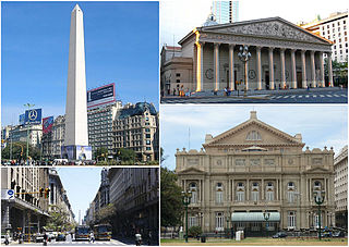
San Nicolás is one of the neighbourhoods of Buenos Aires, Argentina, sharing most of the city and national government Neighborhood of Buenos Aires with neighboring Montserrat and home to much of the financial sector. It is referred usually as El Centro, and the part east of the 9 de Julio Avenue is known as Microcentro.

Almagro is a mostly middle-class barrio or neighbourhood of Buenos Aires, Argentina.

Agronomía is a barrio or district in the centre part of City of Buenos Aires, Argentina. It gets its name from the University of Buenos Aires Faculty of Agronomy based in the neighborhood. Its boundaries are Avenida San Martín, Campana, Avenida Salvador María del Carril, Avenida de los Constituyentes, and Avenida Chorroarín.

Caballito is a barrio (neighborhood) of the Argentine capital, Buenos Aires. It is the only barrio in the administrative division Comuna 6.

Colegiales is a barrio or district in Buenos Aires, Argentina. It is located between Alvarez Thomas av., Forest av., De los Incas av., Virrey del Pino st., Cabildo av., Jorge Newbery st., Crámer st. and Dorrego av. This neighborhood offers a vast amount of contrast and opportunities.
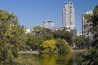
Parque Tres de Febrero, popularly known as Bosques de Palermo, is an urban park of approximately 400 hectares located in the neighborhood of Palermo in Buenos Aires, Argentina. Located between Libertador and Figueroa Alcorta Avenues, it is known for its groves, lakes, and rose gardens.

Parque Patricios is a barrio located on the southern side of Buenos Aires, Argentina belonging to the fourth comuna.

Flores is a middle-class barrio or district in the center part of Buenos Aires city, Argentina. Flores was considered a rural area of the Province of Buenos Aires until 1888 when it was integrated into the city. Flores is the birthplace of Pope Francis.

Mataderos is a barrio (neighbourhood) in Buenos Aires, Argentina. It is one of the three barrios that make up the Comuna 9, alongside Liniers and Parque Avellaneda. Located in the south-west end of the city, it takes its name from the livestock market and various slaughterhouses located within it.

Parque Chas is a neighborhood in Buenos Aires, Argentina, reinstated on 6 December 2005 through By-law No. 1907/06.

Vélez Sársfield is a barrio or district in the western part of Buenos Aires, Argentina, located in the area defined by the streets Segurola Avenue, Juan Agustín García, Lope de Vega Avenue, Juan B. Justo Ave., Corro Ave., Medina, Juan Bautista Alberdi Ave. and Mariano Acosta.

Villa Soldati is a neighbourhood in Buenos Aires, Argentina, located in the South-West of the city. It has a population of approximately 41,000 people, 40% of which live in Barrio Soldati, a public housing development built between 1973 and 1979.
Saavedra is a barrio or neighbourhood of Buenos Aires, Argentina. It is located in the Northern end of the city, close to Nuñez and Villa Urquiza. Its northern border is Avenida General Paz. Among the main features of the neighbourhood is the Parque Saavedra, which has large picnic areas and sports facilities. During weekends, many wealthy inhabitants of Buenos Aires pass through Saavedra en route to their larger estates and country clubs.

Villa del Parque is a barrio (neighbourhood) or district within the city of Buenos Aires, Argentina. Its name translates as Village of the Park and was derived from its earliest beginnings, when several haciendas were all that existed, alongside a growing agricultural park in this section of Buenos Aires Province.

Villa Luro is a barrio (district) of Buenos Aires, Argentina. It is located near the western end of the City of Buenos Aires.

Avenida Figueroa Alcorta is a major thoroughfare in Buenos Aires, Argentina, with a length of over 7 km (4.3 mi) along the city's northside.

Avellaneda Park is a public park in Buenos Aires, Argentina. It is located at the heart of the Parque Avellaneda neighbourhood, which takes its name from the park.

Chacabuco Park is a public park in the Parque Chacabuco section of Buenos Aires.

The Italpark was a theme park in Argentina, which was located where currently is the Parque Thays in the Recoleta neighbourhood of Buenos Aires. It became a landmark of Buenos Aires in its 30 years of existence.


