Rawson is the capital of the Argentine province of Chubut, in Patagonia. It has 24,616 inhabitants in 2010, and it is the chief town of the Rawson Department.

Paraná is the capital city of the Argentine province Entre Ríos, located on the eastern shore of the Paraná River, opposite the city of Santa Fe, capital of the neighbouring Santa Fe Province. The city has a population of 247,863.

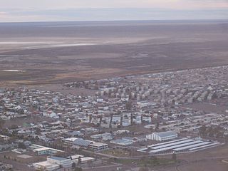
Trelew is a city in the eastern part of the Chubut Province of Argentina. Located in Patagonia, the city is the largest and most populous in the low valley of the Chubut River, with 97,915 inhabitants as of 2010. The Trelew municipality is part of the Rawson Department, whose capital, Rawson, is also the provincial capital.

Esquel is a town in the northwest of Chubut Province in Argentine Patagonia. It is located in Futaleufú Department, of which it is the government seat. The town's name derives from one of two Tehuelche words: one meaning "marsh" and the other meaning "land of burrs", which refers to the many thorny plants including the pimpinella, and the other meaning herbaceous plants whose fruits, when ripe, turn into prickly burrs that stick to the animals' skins and wool or people's clothes as a way of propagation.

Las Flores is a city in the province of Buenos Aires, Argentina, and the only city in Las Flores Partido. It had a population of about 26,000 at the 2022 census [INDEC]. It is located 187 km from Buenos Aires City. The main economic activities in the area are agriculture and cattle breeding.

Paso de los Libres is a city in the east of the province of Corrientes in the Argentine Mesopotamia. It had about 44,000 inhabitants at the 2010 census [INDEC], and is the head town of the department of the same name.
Tinogasta is a city in the west of the province of Catamarca, Argentina, on the right-hand shore of the Abaucán River, about 280 km from the provincial capital San Fernando del Valle de Catamarca. It had about 11,500 inhabitants at the 2010 census [INDEC]. It is the head town of the department of the same name. The name of the city comes from the Kakana words tino ("meeting") and gasta ("town").
Monte Caseros is a city in the south-east of the province of Corrientes in the Argentine Mesopotamia. It has about 37,000 inhabitants as of the 2010 census [INDEC]. It is the head town of the department of the same name, which comprises also the municipalities of Colonia Libertad, Juan Pujol and Mocoretá.

Gobernador Gregores is a town in Santa Cruz Province, Argentina, formerly known as Cañadón León. Ramón Outerello, one of the leaders of the massive strike known as Patagonia rebelde was executed there by a firing squad of the Argentine Army in November 1921.

Nueve de Julio is a city in Buenos Aires Province. It is named for the date of Argentina's Independence Day. It also gives its name to the administrative division of Nueve de Julio Partido. Its UN/LOCODE is AREJO.
San José de Jáchal is a city in the northeast of the province of San Juan, Argentina, located on National Route 40, south of the Jáchal River. It has 21,018 inhabitants per the 2001 census [INDEC], and is the head town of the Jáchal Department.

Ituzaingó is a city in Corrientes Province, Argentina, at the Argentina–Paraguay border.
Bernardo de Irigoyen is a city in the province of Misiones, Argentina. It has 10,889 inhabitants as per the 2001 census [INDEC], and is the head town of the General Manuel Belgrano Department. It carries the name of prominent politician and diplomat Bernardo de Irigoyen.

San Miguel is a city in the northwest region of Greater Buenos Aires, 30 km from the City of Buenos Aires. San Miguel is the county seat of San Miguel Partido, and has been a part of Greater Buenos Aires since the early 2000s. The number of inhabitants was 157,532 according to the 2001 census.
Marcos Juárez is a city in the province of Córdoba, Argentina. It has 24,226 inhabitants per the 2001 census [INDEC], and is the head town of the Marcos Juárez Department. It is located 267 km southeast from the provincial capital Córdoba, on National Route 9, near the provincial boundary with Santa Fe.
Verónica is a town and localidad in Buenos Aires Province, in Argentina. It is the administrative centre for the county (partido) of Punta Indio.
Villa de María del Río Seco is a town in the province of Córdoba, Argentina. It has 3,819 inhabitants per the 2001 census [INDEC], and is the head town of the Río Seco Department. It lies in the north of the province, by National Route 9, about 27 km (17 mi) south of the provincial border with Santiago del Estero and 170 km (106 mi) north-northeast of the provincial capital Córdoba.

Villa Dolores is a city in the province of Córdoba, Argentina, located in the southwestern side of the province. It has a population of 29,854 inhabitants.
San Carlos de Bolívar is a town in Buenos Aires Province, Argentina. It is the administrative centre for Bolívar Partido.

Dolores is a town in Buenos Aires Province, Argentina. It is the administrative centre for Dolores Partido. The town settlement was officially founded by Ramón Lara on 21 August 1817.
