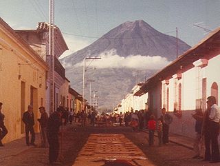
Volcán de Agua is a stratovolcano located in the departments of Sacatepéquez and Escuintla in Guatemala. At 3,760 m (12,340 ft), Agua Volcano towers more than 3,500 m (11,500 ft) above the Pacific coastal plain to the south and 2,000 m (6,600 ft) above the Guatemalan Highlands to the north. It dominates the local landscape except when hidden by cloud cover. The volcano is within 5 to 10 km of the city of Antigua Guatemala and several other large towns situated on its northern apron. These towns have a combined population of nearly 100,000. It is within about 20 km (12 mi) of Escuintla to the south. Coffee is grown on the volcano's lower slopes.
Dulce River is a river in Guatemala, completely contained within the department of Izabal. It is part of a lake and river system that has become a popular cruising sailboat destination.

The Maya Biosphere Reserve is a nature reserve in Guatemala managed by Guatemala's National Council of Protected Areas (CONAP). The Maya Biosphere Reserve covers an area of 21,602 km², one-fifth of the country's total land area.
Biosphere reserves in Guatemala include:

Lachuá Lake is a karstic lake in Guatemala. It is located in the middle of a national park covered with tropical rain forest, northwest of Cobán, near the border between the departments of Alta Verapaz and El Quiché. The lake is near circular in shape and is probably a cenote or doline. The lake water has a slightly sulphurous smell, which may explain the origin of its name: "Lachuá" is derived from the Q'eqchi' words "la chu há" which means "the fetid water". The water contains a relatively high degree of calcite and tree branches fallen into the lake are quickly covered with a white calcite layer.

Grutas de Lanquín is a large limestone cave system located 1 kilometre (0.62 mi) west of Lanquín in Alta Verapaz, Guatemala.
Cuevas del Silvino is a limestone cave system in Guatemala. It is located at km 260 on the road connecting Guatemala City to Puerto Barrios, in the municipality of Morales in the department of Izabal.

El Pino Lake is a lake in Guatemala. It is located 30 km south-southeast of Guatemala City, in the municipality of Barberena in the Santa Rosa Department. The lake has a surface area of 0.72 km² and a maximum depth of 18 m. The lake waters are used for subsistence fishing, sport fishing, and swimming.
Las Victorias National Park is located in Alta Verapaz, Guatemala, on the north-western outskirts of the city of Cobán. Formerly a finca acquired in the mid-19th century by the French coffee grower Jules Rossignon, Las Victorias was designated a national park in 1980. The park covers an area of 82 ha, and is managed by the National Forestry Institute (INAB).
Riscos de Momostenango is an area of curiously shaped sandstone formations located in the municipality of Momostenango in Guatemala.
Cerro El Baúl, also known as El Baúl, is a forested lava dome overlooking the valley of Quetzaltenango. It is located about 3 km north of the Almolonga volcano, at the south-eastern edge of the city of Quetzaltenango in Guatemala. And is one of the city's last remaining green areas.
Cerro Miramundo, also known as Montaña de la Soledad, is a hill covered with dry shrubland located a few kilometers south of the city of Zacapa in Guatemala. The hill represents a panoramic point with an impressive view over the surrounding landscape.
Cerro El Reformador is a hill located in El Progreso, Guatemala. The hill is covered with dry shrubland and offers a panoramic point view of the surrounding landscape.
San José la Colonia is located in Alta Verapaz, Guatemala, on the northern outskirts of the city of Cobán. Formerly a nationalized finca, San José la Colonia was designated a national park in 1976. The park covers an area of 54 ha, and is managed by the National Forestry Institute (INAB).
Sipacate-Naranjo National Park is located along the Pacific coast of Escuintla in Guatemala. The park includes mangrove forests, lagoons and sandy beaches and covers an area of 20 km long and 1 km wide, stretching between the coastal towns of Sipacate and El Naranjo.
El Rosario National Park is located in El Petén, Guatemala, on the eastern edge of the town of Sayaxché.. The park is named after laguna El Rosario, a small lake within its boundaries, and was formerly a state owned finca managed by the National Forestry Institute (INAB). In 1980 it was declared a national park. The park covers an area of 11.05 km2, including the El Rosario lake, which has a surface area of 4 ha in the dry season, though it is considerably larger during the rainy season.
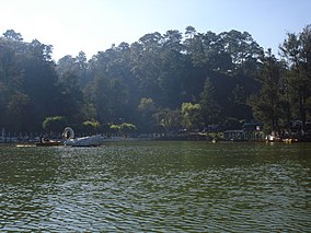
Naciones Unidas National Park is a forested park area of 4.91 km2, located 21 km south of Guatemala City, just north of Lake Amatitlán in the municipality of Villa Nueva. It is one of the last remaining nature reserves in the Guatemala City Metropolitan Area.
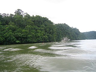
Punta de Manabique is a small peninsula that separates Amatique Bay from the Gulf of Honduras. It is located on Guatemala's east coast, some 20 km north of Puerto Barrios.

Laguna de Ipala is a crater lake in Guatemala. The lake is located in the south-eastern Chiquimula Department at the bottom of a one kilometre (0.62 mi) wide crater of the Ipala Volcano. The lake has a surface area of 0.52 km2 (0.20 sq mi) and is situated at an altitude of 1493 m.
Laguna de Calderas is a crater lake in the municipality of Amatitlán, Guatemala, Guatemala. It is located approximately 6 km south of Lake Amatitlán and 3 km north of the currently active vent of the Pacaya volcano. The lake has a surface area of 11 ha and is situated at an altitude of 1778 m.