
Sucre is the constitutional capital of Bolivia, the capital of the Chuquisaca Department and the 6th most populated city in Bolivia. Located in the south-central part of the country, Sucre lies at an elevation of 2,810 meters. This relatively high altitude gives the city a subtropical highland climate with cool temperatures year-round.

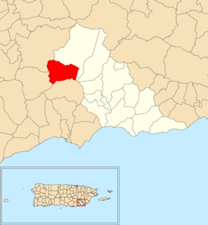
Peñuelas is a municipality in Puerto Rico located in the southern coast of the island, south of Adjuntas, east of Guayanilla, west of Ponce and north of the Caribbean Sea. Peñuelas is spread over 12 barrios and Peñuelas Pueblo. It is part of the Yauco Metropolitan Statistical Area. Peñuelas is known as "La Capital del Güiro" and "El Valle de los Flamboyanes". In 2010, Peñuelas had a population of 24,282.

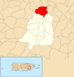
Barranquitas is a small mountain municipality located in the central region of Puerto Rico, south of Corozal and Naranjito; north of Coamo and Aibonito; west of Comerío and Cidra; and east of Orocovis. Barranquitas is spread over 6 barrios and Barranquitas Pueblo. It is part of the San Juan-Caguas-Guaynabo Metropolitan Statistical Area.

Patillas is a municipality of Puerto Rico located in the southeastern coast, south of San Lorenzo; west of Yabucoa and Maunabo; and east of Guayama and Arroyo. It is spread over 15 barrios and Patillas Pueblo. It is part of the Guayama Metropolitan Statistical Area.
Toa Alta is a municipality of Puerto Rico located in the northern coast of the island, north of Naranjito; south of Dorado and Toa Baja; east of Vega Alta and Corozal; and west of Bayamón. Toa Alta is spread over eight barrios and Toa Alta Pueblo. It is part of the San Juan-Caguas-Guaynabo metropolitan statistical area.

Trujillo Alto is a municipality of Puerto Rico located in the Northern Coastal Plain and in the karst zone, north of Caguas, and Gurabo; southeast of San Juan, and west of Carolina. Trujillo Alto is part of the San Juan Metropolitan Area, which includes the municipalities of Bayamón, Guaynabo, Cataño, and Toa Baja. The city is spread over 6 barrios and Trujillo Alto barrio-pueblo. It is part of the San Juan-Caguas-Guaynabo Metropolitan Statistical Area.
The Biobío Region, is one of Chile's sixteen regions. With a population of 1.5 million, thus being the third most populated region in Chile, it is divided into three provinces: Arauco, Biobío and Concepción. The latter contains its capital and largest city, Concepción, a major city and metro area in the country. Los Ángeles, capital of the Biobío Province, is another important city in the region.
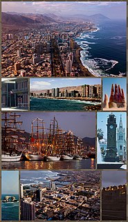
Antofagasta is a port city in northern Chile, about 1,100 kilometres (700 mi) north of Santiago. It is the capital of Antofagasta Province and Antofagasta Region. According to the 2015 census, the city has a population of 402,669.

The Biobío River is the second largest river in Chile. It originates from Icalma and Galletué lakes in the Andes and flows 380 km to the Gulf of Arauco on the Pacific Ocean.
Chapinero is the 2nd locality of Bogotá, capital of Colombia. It is located in the north of the city and is one of the more affluent districts of the city. This district is mostly inhabited by upper class residents. The boundaries are Calle 39 in the south, Avenida Caracas in the west, Calle 100 in the north and the Eastern Hills in the east.
Rosamorada is a municipality of the state of Nayarit in Mexico. It is located in the extreme north of the state. The area of the municipality is 2,073 km² and the population was 32, 217 in 2005, showing a significant decrease from 1980 when it was 34,695. Most of the population is still rural with the major settlements being Rosamorada with 3,393 inhabitants; San Vicente with 4,556; Los Pericos with 2,441; Chilapa with 2,277; Pimientillo with 1,824 and El Tamarindo with 1,544.
Battle of Quiapo in the Arauco War was the final battle in the campaign of García Hurtado de Mendoza against the Mapuche under the toqui known as Lemucaguin or Caupolicán the younger. It was fought in Quiapo, Arauco Province, Chile on December 13, 1558.

Pichilemu, originally known as Pichilemo, is a beach resort city and commune in central Chile, and capital of Cardenal Caro Province in the O'Higgins Region. The commune comprises an urban centre and twenty-two villages, such as Ciruelos, Cáhuil, and Espinillo. It is located southwest of Santiago, the capital of Chile. Pichilemu had over 13,000 residents as of 2012.
Quebrada is a barrio in the municipality of San Lorenzo, Puerto Rico. Its population in 2010 was 3,354.
Quebrada Arriba is a barrio in the municipality of Patillas, Puerto Rico. Its population in 2010 was 711.

Callejones is a barrio in the municipality of Lares, Puerto Rico. Its population in 2010 was 4,575. Machos Cave and Pajita Cave are located in Callejones.

Quebrada Infierno is a barrio in the municipality of Gurabo, Puerto Rico. Its population in 2010 was 773.
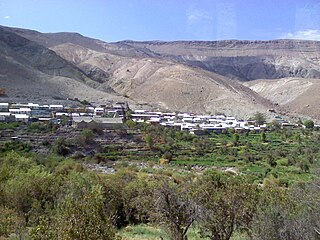
Huaviña is a Chilean town. The town is located in the foothills of the commune of Huara in a canyon known as Quebrada de Tarapacá. It is located 80km from the seat of the municipality and 153 kilometers from Iquique. Its ain economic activity is agriculture, in addition to raising various animals for sale.
