
The Nevado del Ruiz, also known as La Mesa de Herveo is located on the border of the departments of Caldas and Tolima in Colombia, about 129 kilometers (80 mi) west of the capital city Bogotá. It is a stratovolcano composed of many layers of lava alternating with hardened volcanic ash and other pyroclastic rocks. Nevado del Ruiz has been active for about two million years, since the Early Pleistocene or Late Pliocene, with three major eruptive periods. The current volcanic cone formed during the present eruptive period, which began 150 thousand years ago.

The Aconcagua River is a river in Chile that rises from the conflux of two minor tributary rivers at 1,430 metres (4,690 ft) above sea level in the Andes, Juncal River from the east and Blanco River from the south east. The Aconcagua river flows westward through the broad Aconcagua valley and enters the Pacific Ocean near the city of Concon, 20 kilometres (12 mi) north of Valparaíso.

Salento is a town and municipality in the north-east of the department of Quindío, Colombia. The municipality covers an area of 377.67 km2. It was the first settlement in Quindío of the modern era, and the first municipality founded in the department. The town of Salento itself is located 24 km northeast of the departmental capital Armenia. In 2005 the municipality of Salento had an estimated population of 7247, of which 3597 lived in the main urban zone.

The Longaví River is a tributary of the Maule River, in the Province of Linares, Maule Region of Chile. The Longaví is 120 km long.

Nevado de Longaví is a volcano in the Andes of central Chile. The 3,242 m (10,636 ft) high volcano lies in the Linares Province, which is part of the Maule Region. It features a summit crater and several parasitic vents. The volcano is constructed principally from lava flows. Two collapses of the edifice have carved collapse scars into the volcano, one on the eastern slope known as Lomas Limpias and another on the southwestern slope known as Los Bueye. The volcano features a glacier and the Achibueno and Blanco rivers originate on the mountain.

Valle Nevado is a ski resort located on the El Plomo foothills in the Andes Mountains, at 46 km to the east of Santiago, the capital of Chile. Founded in 1988 by French entrepreneurs, it includes housing facilities along with around 900 hectares of skiing area.

Nevado Tres Cruces National Park Located in the Atacama Region of Chile at 93.2 miles from Copiapó. It includes Laguna Santa Rosa, Laguna del Negro Francisco, and a part of the Salar de Maricunga. The park is divided into two zones, the northern zone encompassing the southern portion of Salar de Maricunga and Laguna Santa Rosa, and the southern area the Laguna del Negro Francisco. The park is named after Nevado Tres Cruces, which dominates the landscape of the area. The Nevado Tres Cruces National Park is managed by CONAF, which offers two refuges in the area: one at the south of Negro Francisco Lagoon and other at the west of Santa Rosa Lagoon. The administration charges a fee to enter the park which is $2.000 CLP and $500 CLP for children.The park is open from October to April from 8 in the morning to 6 in the afternoon.

The Cocora valley is a valley in the department of Quindío in the country of Colombia. It is located in the Central Cordillera of the Andean mountains. "Cocora" was the name of a Quimbayan princess, daughter of the local chief Acaime, and means "star of water".

The Nevado del Tolima is a Late Pleistocene to recently active andesitic stratovolcano located in the Tolima department, Colombia. The volcano lies south of Nevado del Ruiz volcano and is situated within the Los Nevados National Natural Park. The volcano, whose most recent activity dates to 1943 and last major eruption around 3600 years ago, overlies the Eocene El Bosque Batholith, dated at 49.1 ± 1.7 Ma.

Nevado del Huila at 5,364 metres (17,598 ft), is the highest volcano in Colombia, located at the tripoint of the departments of Huila, Tolima and Cauca. It is visible from the city of Cali. The andesitic volcano is located on top of the Ibagué Batholith.

Líbano is a town and municipality in the Tolima department of Colombia. The population of the municipality was 41,650 as of the 2005 census. Along with Honda, Tolima, Líbano is the seat of the Roman Catholic Diocese of Líbano–Honda.
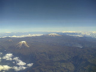
Los Nevados National Natural Park is a national park located in the Cordillera Central of the Colombian Andes. The park sourrounds the northern volcanic complex formed by Nevado del Ruiz, Nevado del Tolima, Nevado de Santa Isabel, the paramillos of Cisne, Santa Rosa and Quindío and the Cerro Bravo and Cerro Machín.

Los Fayos is a municipality located in the province of Zaragoza, Aragon, Spain. According to the 2010 census the municipality has a population of 153 inhabitants. Its postal code is 50513.
Carbonero el Mayor is a municipality located in the province of Segovia, Castile and León, Spain. According to the 2004 census (INE), the municipality has a population of 2,469 inhabitants.
Arteaga is a municipality located in the southern region of the Mexican state of Michoacán. The municipality has an area of 3,454.71 square kilometres and is bordered to the north by the municipality of La Huacana, to the east by Churumuco and the state of Guerrero, to the south by Lázaro Cárdenas, and to the west by Coalcomán de Vázquez Pallares, Tumbiscatío, Aguililla and Aquila. The municipality had a population of 21,173 inhabitants according to the 2005 census. Its municipal seat is the city of the same name.
Zentla Municipality is a municipality of Veracruz, Mexico. The seat is Colonia Manuel Gonzalez.

Colusa Rancheria is an unincorporated community in Colusa County, California. It lies at an elevation of 59 feet. The inhabitants belong to the Wintun tribe. It was established in 1907. As of the 2010 Census the population was 76.

Nightingale is a hamlet in southern Alberta, Canada within Wheatland County. It is located 4 kilometres (2.5 mi) west of Highway 21, approximately 53 kilometres (33 mi) east of Calgary.
The small town Los Mazos is situated in the Municipality of Tuxpan, Jalisco. It has approximately 190 inhabitants. Los Mazos sits at a height of 1,780 meters. Located on the skirts of a couple of volcanoes, an inactive one called El Nevado de Colima and an active one called the Volcan de Colima, also known as the Volcan de Fuego or "fire volcano". It is located near the city of Tuxpan and is located within its municipality. The town of Los Mazos once belonged to a bigger hacienda and shares a common water system and storage pools called "tanques" with Las Canoas, another few tanques are located throughout the region. The tanques are constructed with cement and stone, and coated in a mixture of cement and ox blood giving them a dark ocher look, these tanques were used to store potable, cattle and plant water.

Nevado de Acay is a 5,950-metre-high (19,520 ft) mountain in Argentina. It is a volcanic intrusion that formed during the Miocene and was later exposed. The intrusion is formed by monzonite and is associated with a fault system that also connects to neighbouring volcanoes.


