
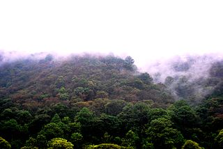
Parque Nacional Los Volcanes, also known as Cerro Verde National Park, is a large national park in El Salvador.
The park includes three volcanoes: Cerro Verde, Izalco, and Santa Ana. [1]
Parque Nacional Los Volcanes, also known as Cerro Verde National Park, is a large national park in El Salvador.
The park includes three volcanoes: Cerro Verde, Izalco, and Santa Ana. [1]

Xalapa or Jalapa, officially Xalapa-Enríquez, is the capital city of the Mexican state of Veracruz and the name of the surrounding municipality. In the 2020 census the city reported a population of 443,063 and the municipality of which it serves as municipal seat reported a population of 488,531. The municipality has an area of 118.45 km2. Xalapa lies near the geographic center of the state and is the second-largest city in the state after the city of Veracruz to the southeast.

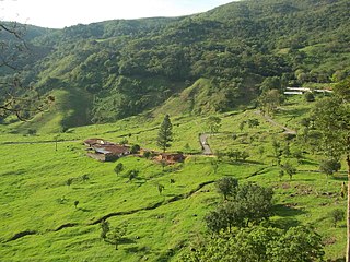
Ahuachapán is a city, municipality, and the capital of the Ahuachapán Department in western El Salvador. The municipality, including the city, covers an area of 244.84 km2 and as of 2007 has a population of 110,511 people. Situated near the Guatemalan border, it is the westernmost city in the country and is the center of an agricultural region producing primarily coffee.

Cerros de Amotape National Park is a protected area located in the regions of Piura and Tumbes in northern Peru.

Izalco is an active stratovolcano on the side of the Santa Ana Volcano, which is located in western El Salvador. It is situated on the southern flank of the Santa Ana volcano. Izalco erupted almost continuously from 1770 to 1958 earning it the nickname of "Lighthouse of the Pacific", and experienced a flank eruption in 1966. During an eruption in 1926, the village of Matazano was buried and 56 people were killed. The volcano erupted on highly arable land which was used for the production of coffee, cacao, and sugar cane.
The Central American pine–oak forests is a tropical and subtropical coniferous forests ecoregion in the mountains of northern Central America and Chiapas state in southern Mexico.

The Naguanagua municipality is one of the 14 municipalities (municipios) that makes up the Venezuelan state of Carabobo and, according to the 2011 census by the National Institute of Statistics of Venezuela, the municipality has a population of 157,437. The town of Naguanagua is the shire town of the Naguanagua Municipality. It forms part of the greater Valencia Metropolitan Area in Venezuela. It is in the valley of the Cabriales River at the base of Cerro El Café and the El Trigal Mountain. Valencia and Naguanagua form a continuous urban area. The highway that runs from the centre of Valencia towards Puerto Cabello passes through this community; Bolivar Avenue in Valencia becomes University Avenue in Naguanagua on the northern side of a traffic roundabout, or redoma.

The Three Eyes National Park is a 50-yard open-air limestone cave located in the Mirador del Este park, in the Santo Domingo Este municipality of the Dominican Republic. A series of three lakes, or ojos, the site is currently one of the most visited tourist attractions in the country.
Juglans venezuelensis, or nogal de Caracas, is a species of black walnut endemic to Venezuela. It is a small tree which bears 1 inch nuts.

The Sierra de las Quijadas National Park is a national park located in the northwestern part of the Argentine province of San Luis. It was established on December 10, 1991, to protect the natural features, representative of the Semiarid Chaco and the High Monte ecoregions.

Casa Blanca is a pre-Columbian Maya archeological site in Chalchuapa, El Salvador. The site possesses several pyramids dating to the Late Preclassic period and the Classic period. This ruin is part of the Chalchuapa archaeological zone and displays influences from the Olmecs and from Teotihuacan. It is closely related to the ruins of Tazumal and San Andrés. The government purchased the park in 1977 and it was given the name of the coffee plantation upon which it was situated. There are many pyramids at Casa Blanca but only two have been partially restored. Casa Blanca is located in the department of Santa Ana. Casa Blanca has been closed to the public and is undergoing restoration work; it has a site museum with exhibits that include Maya ceramics and other artifacts.

Tirgua National Park, also known as General Manuel Manrique National Park, is a national park in Venezuela. It protects the headwaters of several waterways, especially the river Tirgua, which gives its name to the park.
The Chorro El Indio National Park Is a national park of Venezuela located to the east of San Cristóbal, Táchira State, in the mountain range the Maravilla, has access by the highway San Cristóbal - Macanillo - Potosí.

The General Juan Pablo Peñaloza National Park, also Páramos Batallón y La Negra National Park, is a national park of Venezuela that is formed by several páramos. Among them Batallón and La Negra, which are an important source of water supply. It is located between the states Mérida and Táchira, northwest of the Táchira Depression in the Páramos de El Batallón and La Negra in Venezuela.

The Península de Paria National Park, or Peninsula of Paria National Park, Is a national park on Paria Peninsula in Venezuela.
The Yapacana National Park Also Cerro Yapacana National Park Is a protected area with the status of national park in the South American country of Venezuela which was formed on December 12, 1978 by executive decree of President Carlos Andres Perez. It is located southwest of the confluence of the Ventuari River on the Orinoco River, in the jurisdiction of the Atabapo municipality of Amazonas state.

The Aguaro-Guariquito National Park, also rendered as Aguaro Guariquito National Park, is a protected area with the status of national park in the South American country of Venezuela. Located in the region of the Llanos, it extends over the municipalities of Francisco de Miranda and Jose Rondon in Guárico state.

The Cerro El Copey National Park Also Cerro El Copey-Jóvito Villalba National Park Is a protected area with the status of a national park located to the east of the Caribbean island of Margarita, in the highest mountainous region of Nueva Esparta State in Venezuela. It was created in 1974 with the purpose of protecting an outstanding physiographic feature with an ecosystem that includes several plant formations, high levels of endemism and the only permanent water sources of the island.

The Sierra del Ajusco-Chichinauhtzin, also known as Serranía del Ajusco or Sierra de Chichinauhtzin, is a Mexican mountain range located between Mexico City and the states of Morelos and Mexico. It makes up the southern part of the mountain necklace that surrounds Mexico City. It is made up of more than one hundred volcanic cones, among which are: Tláloc, Chichinauhtzin (3,430 metres, Xitle (3,100 metres, Cerro Pelado (3,600 metres and Cuauhtzin (3,510 metres. Its maximum height is at the Cruz del Marqués peak on the Ajusco volcano.
13°49′38″N89°37′24″W / 13.8272°N 89.6233°W
| | This El Salvador location article is a stub. You can help Wikipedia by expanding it. |