
The Jaú National Park is a national park located in the state of Amazonas, Brazil. It is one of the largest forest reserve in South America, and part of a World Heritage Site.

El Cajas National Park or Cajas National Park is a national park in the highlands of Ecuador. It is located about 30 km west from Cuenca, the capital of the province of Azuay. The area of 285.44 km2 between 3100m and 4450m above sea level is characterized by páramo vegetation on a jagged landscape of hills and valleys. It was declared a National Park on November 5, 1996 by resolution N° 057.
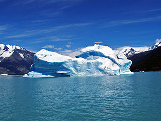
Los Glaciares National Park is a federal protected area in Santa Cruz Province, Argentina.

Manú National Park is a national park and biosphere reserve located in the regions of Madre de Dios and Cusco in Peru. It protects a diverse number of ecosystems including lowland rainforests, cloud forests and Andean grasslands.

Huascarán National Park is a Peruvian national park that comprises most of the mountain range known as Cordillera Blanca which is part of the central Andes, in the region of Ancash. The park covers an area of 340,000 ha and is managed by the Peruvian Network of Protected Natural Areas: SERNANP. It was designated as a World Heritage Site in 1985 by UNESCO, is also a well-known mountaineering spot and harbors a unique biodiversity with plant species such as the Queen of the Andes, trees of the genera Polylepis and Buddleja, and animals such as spectacled bears, condors, vicunas and tarucas.

Cerros de Amotape National Park is a protected area located in the regions of Piura and Tumbes in northern Peru.

The Iguazú National Park is a national park of Argentina, located in the Iguazú Department, in the north of the province of Misiones, Argentine Mesopotamia. It has an area of 677 km2 (261 sq mi).

Torres del Paine National Park is a national park encompassing mountains, glaciers, lakes, and rivers in southern Chilean Patagonia. The Cordillera del Paine is the centerpiece of the park. It lies in a transition area between the Magellanic subpolar forests and the Patagonian Steppes. The park is located 112 km (70 mi) north of Puerto Natales and 312 km (194 mi) north of Punta Arenas. The park borders Bernardo O'Higgins National Park to the west and the Los Glaciares National Park to the north in Argentine territory. Paine means "blue" in the native Tehuelche (Aonikenk) language and is pronounced PIE-neh, while Torres means "towers". It was established as a National Park in 1959.

Cutervo National Park , established in 1961, is the oldest protected area in Peru. It is located in the northern Peruvian Andes, in the region of Cajamarca. The park was extended to 8,214 hectares (31.71 sq mi) and protects areas of Andean montane forests and paramo for headwater conservation. Moreover, those areas are the habitat of animal species like the spectacled bear, the mountain tapir, and the oilbird; and plant species like the Andean wax palms.

Cotzumalhuapa archaeological culture is from the piedmont area of the Escuintla Department, Guatemala. The Cotzumalhuapa archaeological zone is near the town of Santa Lucía Cotzumalguapa.

Anavilhanas National Park is a national park that encompasses a huge river archipelago in the Rio Negro in the state of Amazonas, Brazil. It is part of a World Heritage Site.
The Trifinio Fraternidad Transboundary Biosphere Reserve is a transboundary protected area located where the borders of El Salvador, Guatemala and Honduras meet. It protects the Montecristo massif and its cloud forests across the three countries' borders.
Cara Sucia River is a river of El Salvador. It arises in the foothills of the El Imposible National Park and flows westward through the area of Cara Sucia in the Ahuachapán Department region to a bay near El Zapote.

Cara Sucia is a Mesoamerican archaeological site on the Pacific coastal plain of western El Salvador. It was occupied for some 1,800 years, and is particularly noted as one of the southeasternmost sites of the Late Classic Cotzumalhuapa culture which extended over much of the Pacific drainage of Guatemala and included part of the Salvadoran departments of Ahuachapán and Sonsonate.
The Old Providence McBean Lagoon National Natural Park is a national park located on the northeast side of Providencia Island in the Archipelago of San Andrés, Providencia and Santa Catalina, Colombia.
El Tuparro National Natural Park is a national park located in the Vichada Department in the Orinoquía Region of Colombia. It is the only protected area in the Eastern Plains under Colombia's Natural Parks System.
The Tamá National Natural Park is a national park located in the Tamá Massif of the Andean Region of Colombia, between the municipalities Toledo and Herrán, in the department of Norte de Santander, in the northeastern part of the Eastern Ranges of the Colombian Andes. One of the main attractions of the park is a 820-metre-high (2,690 ft) waterfall, one of the world's highest.

Chiribiquete National Natural Park is the largest national park in Colombia and the largest tropical rainforest national park in the world. It was established on 21 September 1989 and has been expanded twice, first in August 2013 and then in July 2018. The park occupies about 43,000 km2 (17,000 sq mi) and includes the Serranía de Chiribiquete mountains and the surrounding lowlands, which are covered by tropical moist forests, savannas and rivers.

