Cara Sucia is a Mesoamerican archaeological site on the Pacific coastal plain of western El Salvador. It was occupied for some 1,800 years, and is particularly noted as one of the southeasternmost sites of the Late Classic Cotzumalhuapa culture which extended over much of the Pacific drainage of Guatemala and included part of the Salvadoran departments of Ahuachapán and Sonsonate.
Cara Sucia was settled around 900 BC, in the Middle Preclassic period. Over the Preclassic, it was closely affiliated with Chalchuapa and other early Maya sites in the territory of western El Salvador, as attested by the presence of the Lamatepeque, Jicalapa, Pinos, Izalco, Santa Tecla and other ceramic groups.[1][2]
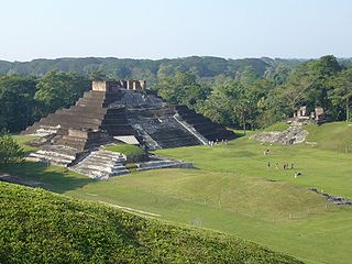
The eruption of Ilopango circa 540 AD marked the abandonment of Cara Sucia's region. The site was resettled a few decades later, perhaps around 600 AD, but the material culture of its new occupants represented a complete break with its Maya past, identifying it as a Cotzumalhuapa settlement. It was at this time that the main structures at the site were built, including an acropolis, two enclosed ballcourts, and a 14-meter-high pyramid, as well as several minor pyramids and platforms. The site's monumental core is relatively compact, and is divided by a massive terrace into two leveled areas. Cotzumalhuapan monumental architecture is commonly faced with field stone, and at Cara Sucia, large river cobbles were used, selected to be of similar size. The acropolis supported perishable thatched structures with wattle-and-daub walls which were burned at end of the site's occupation. Carbonized thatch from one of these structures yielded two calibrated radiocarbon dates of 920 AD each. Pottery from this period shares several types known from the central Cotzumalhuapa area, such as Tiquisate, as well as some local varieties. Mold-made figurines are very common, most of which functioned as whistles, and in the excavations conducted by Jorge Mejía, a burial was discovered with a set of figurine molds. Figurines reflect a diversity of local fauna (such as monkeys, felines, and macaws), but most frequently represent women. In consideration of the local variants in the material culture of Cara Sucia in regard to the central Cotzumalhuapa area, a distinct Late Classic phase was defined for the site: Tamasha.[2]
The coastal plain around Cara Sucia is very suitable for growing cotton, and the abundance of malacates at the site indicates the importance of this crop and of textile manufacture. It has been suggested that the production of salt and cacao may have been other vital economic activities for the inhabitants of the site.
In addition to some small settlements with Tamasha occupation, two other affiliated monumental centers are presently known in El Salvador, La Danta (on the border with Guatemala) and Huiscoyolate (next to Izalco).
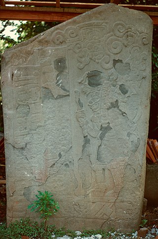
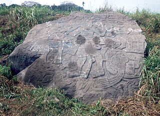
Four large stone sculptures have been found at Cara Sucia. They were removed from the site between the end of 19th and beginning of the 20th centuries, and their original locations within the site are unknown. The sculptures follow the canons of Cotzumalhuapa art. Only one of the sculptures (designated as Monument 1) is in the collection of the National Museum of Anthropology, and consists of a disk with a feline face. The Cotzumalhuapa culture is noted for its portable sculptures related with the ballgame, especially yokes and hachas, both of which have been found at Cara Sucia, La Danta, and Huiscoyolate.
Relations between the Tamasha area and that of the principal contemporary culture of western El Salvador, Payu, were apparently quite limited. The Payu commercial ware called Copador Polychrome was massively produced and distributed in its time, but is very scarcely represented at Cara Sucia. On the other hand, Tamasha figurines, which were very commonplace within their area, have only rarely been found at Payu sites.
The Tamasha phase has a Terminal Classic facet marked by the introduction of the Cozatol ceramic group and a local fine paste ware. Cara Sucia's abandonment in the early 10th century AD is a matter requiring further investigation. Although the burning of structures on the acropolis may suggest a violent end, it is equally possible that it was caused by lightning strikes following the site's abandonment, since at the time these structures the most prominent points on the coastal plain within a radius of kilometers.
Studies
Historian Santiago Barberena was the first to mention Cara Sucia in 1892, and had Monument 1 transferred to the National Museum. The site was covered by coastal forest until 1964, when bulldozers were used to clear the land for growing cotton, resulting in severe damage to the site; witnesses relate that numerous small platforms (presumably residential) were completely destroyed at that time. In 1967, Stanley Boggs visited and mapped the exposed site. In 1986, Lee Parsons identified Cara Sucia as a Cotzumalhuapa site based on the style of its sculptures.[3] The Hacienda Cara Sucia, in which the site was located, was expropriated by the 1980 Agrarian Reform. The estate was abandoned by its former owners, but a year elapsed before government authorities took effective control of the hacienda. Taking advantage of this vacuum of authority, hundreds of local residents began to loot Cara Sucia on a daily basis, eventually digging over 5,000 pits. Traffickers of antiquities circulated through the site to purchase artifacts as they were being found. This was the worst episode of archaeological depredation ever to take place in El Salvador, and artifacts from Cara Sucia were sold in the United States and other countries (this situation prompted the enactment of the first bilateral agreement between El Salvador and the United States for import restrictions of archaeological artifacts, subscribed in 1987). In 1981, the governmental Department of Archaeology acted to halt the looting, assigning Jorge Mejía to confront the looters and fence most of the site. Over a year and a half, Mejía conducted very extensive excavations on the acropolis and other structures. In 1983, Amaroli documented this work, as well as the damage from looting, and undertook limited excavations; in addition, the site was equipped with rustic infrastructure to open as an archaeological park, with a parking area, signage, interpretative center and an interpretative trail. This effort was aborted in 1984, when all financing was cut for Cara Sucia. Amaroli undertook further work at Cara Sucia in 1986, establishing that its relationship with the Cotzumalhuapa culture was not only in regard to its sculptures but also in its shared architecture and ceramics, findings which were summarized by Rafael Cobos. These ceramic relations were further demonstrated in the 2006 investigations by Regina Moraga, Elisa Mencos and Sébastien Perrot-Minnot.
The Ministry of Culture currently maintains one park guard at Cara Sucia. The site can be visited, but there are no set hours, and most structures are covered by brush.
↑ Parsons, Lee A (1986). The origins of Maya art: monumental stone sculpture of Kaminaljuyu, Guatemala, and the southern Pacific coast. Washington, D.C.: Dumbarton Oaks Research Library and Collection. ISBN9780884021483. OCLC906469565.
El Mirador is a large pre-Columbian Middle and Late Preclassic Maya settlement, located in the north of the modern department of El Petén, Guatemala. It is part of the Mirador-Calakmul Karst Basin of northern Guatemala.
Tak'alik Ab'aj is a pre-Columbian archaeological site in Guatemala. It was formerly known as Abaj Takalik; its ancient name may have been Kooja. It is one of several Mesoamerican sites with both Olmec and Maya features. The site flourished in the Preclassic and Classic periods, from the 9th century BC through to at least the 10th century AD, and was an important centre of commerce, trading with Kaminaljuyu and Chocolá. Investigations have revealed that it is one of the largest sites with sculptured monuments on the Pacific coastal plain. Olmec-style sculptures include a possible colossal head, petroglyphs and others. The site has one of the greatest concentrations of Olmec-style sculpture outside of the Gulf of Mexico, and was made a World Heritage Site in 2023 because of its long history of occupation.
Ahuachapán is a city, municipality, and the capital of the Ahuachapán Department in western El Salvador. The municipality, including the city, covers an area of 244.84 km2 and as of 2007 has a population of 110,511 people. Situated near the Guatemalan border, it is the westernmost city in the country and is the center of an agricultural region producing primarily coffee.
Cotzumalhuapa archaeological culture is from the piedmont area of the Escuintla Department, Guatemala. The Cotzumalhuapa archaeological zone is near the town of Santa Lucía Cotzumalguapa.
Cuzcatlan was a pre-Columbian Nahua state confederation of the Mesoamerican postclassical period that extended from the Paz river to the Lempa river ; this was the nation that Spanish chroniclers came to call the Pipils or Cuzcatlecos. No codices survive that shed light on this confederation except the Annals of the Cakchiquels, although Spanish chroniclers such as Domingo Juarros, Palaces, Lozano, and others claim that some codices did exist but have since disappeared. Their Nawat language, art and temples revealed that they had significant Mayan and Toltec influence from the ties they had with the Itza in Yucatan. It is believed that the first settlers to arrive came from the Toltec people in central Mexico, mostly Puebla during the Chichimeca-Toltec civil wars in the 10th century AD.
El Baúl is a Pre-Columbian archaeological site in present-day Escuintla Department, Guatemala. El Baúl, along with the sites of Bilbao and El Castillo, is part of the Cotzumalhuapa Archaeological Zone. It was occupied during the prehistoric Formative stage of the Americas.
Machaquila is a major ruined city of the Maya civilization in what is now the El Peten department of Guatemala.
Kinal is a major pre-Columbian Maya archaeological site in the Petén Department of the modern-day Petén Department of northern Guatemala. The major occupational phase for the site dates from the Late Classic period of Mesoamerican chronology, with evidence for a substantial and expansionary building program dating from the first half of the 8th century AD. Kinal was discovered in the 1960s by archaeologist Ian Graham while he was carrying out an archaeological survey of the region, although no excavations were undertaken at the site at that time.
Yaxha is a Mesoamerican archaeological site in the northeast of the Petén Basin in modern-day Guatemala. As a ceremonial centre of the pre-Columbian Maya civilization, Yaxha was the third largest city in the region and experienced its maximum power during the Early Classic period.
La Blanca is a pre-Columbian Mesoamerican archaeological site in present-day La Blanca, San Marcos Department, western Guatemala. It has an occupation dating predominantly from the Middle Preclassic period of Mesoamerican chronology. This site belongs to the later period of the Mokaya culture.
El Tintal is a Maya archaeological site in the northern Petén region of Guatemala, about 25 kilometres (16 mi) northeast of the modern-day settlement of Carmelita, with settlement dating to the Preclassic and Classic periods. It is close to the better known sites of El Mirador, to which it was linked by causeway, and Nakbé. El Tintal is a sizeable site that includes some very large structures and it is one of the four largest sites in the northern Petén; it is the second largest site in the Mirador Basin, after El Mirador itself. El Tintal features monumental architecture dating to the Middle Preclassic similar to that found at El Mirador, Nakbé and Wakna. Potsherds recovered from the site date to the Late Preclassic and Early Classic periods, and construction continued at the site in the Late Classic period.
Bilbao is a Mesoamerican archaeological site about 1 mile (1.6 km) from the modern town of Santa Lucía Cotzumalguapa in the Escuintla department of Guatemala. The site lies among sugar plantations on the Pacific coastal plain and its principal phase of occupation is dated to the Classic Period. Bilbao was a major centre belonging to the Cotzumalhuapa culture with its main occupation dating to the Late Classic. Bilbao is the former name of the plantation on which the site lies and from which it has derived its name.
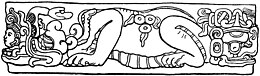
Potbelly sculptures are in-the-round sculptures of obese human figures carved from boulders. They are a distinctive element of the sculptural tradition in the southern Maya area of Mesoamerica. The precise purpose of potbelly sculptures is unknown, although they appear to have been the focus of public veneration and ritual directed by the ruling elite. Although this sculptural tradition is found within the southern Maya area, it has been recognized that the sculptures themselves are non-Maya.
Itzan is a Maya archaeological site located in the municipality of La Libertad in the Petén Department of Guatemala. Various small structures at the site were destroyed in the 1980s during oil exploration activities by Sonpetrol and Basic Resources Ltd, prompting rescue excavations by archaeologists. In spite of its small size, the site appears to have been the most politically important centre in its area, as evidenced by its unusually large quantity of monuments and the size of its major architecture.
La Blanca is a Maya pre-Columbian Mesoamerican archaeological site in the municipality of Melchor de Mencos in the northern Petén Department of Guatemala. It has an occupation dating predominantly from the Middle Preclassic period of Mesoamerican chronology. This site belongs to the later period of the Mokaya culture. The site is located in the lower reaches of the Mopan River valley and features a large acropolis complex. Activity at the site has been dated as far back as the Early Classic, with principal occupation of the site occurring in the Late Classic period, although some level of occupation continued into the Early Postclassic.
Comalcalco is an ancient Maya archaeological site in the State of Tabasco, Mexico, adjacent to the modern city of Comalcalco and near the southern coast of the Gulf of Mexico. It is the only major Maya city built with bricks rather than limestone masonry and was the westernmost city of the Maya civilisation. Covering an area of 7 km2 (2.7 sq mi), Comalcalco was founded in the Late Classic period and may have been a satellite or colony of Palenque based on architectural similarities between the two. The city was a center of the Chontal Maya people.
Cihuatán is a major pre-Columbian archaeological site in central El Salvador. It was a very large city located in the extreme south of the Mesoamerican cultural area, and has been dated to the Early Postclassic period of Mesoamerican chronology.
Guaytán is an archaeological site of the Maya civilization in the municipality of San Agustín Acasaguastlán, in the department of El Progreso, in Guatemala. It is the most important pre-Columbian archaeological site of the middle drainage of the Motagua River.
References
Amaroli, Paul (1987). Informe preliminar de las excavaciones arqueológicas en Cara Sucia, Departamento de Ahuachapán, El Salvador. Biblioteca Especializada, Museo Nacional de Antropología Dr. David J. Guzmán, San Salvador, El Salvador.
Boggs, Stanley H. (1975). Las esculturas espigadas y otros datos sobre las ruinas de Cara Sucia, departamento de Ahuachapán. Anales del Museo Nacional "David J. Guzmán, no. 42-48:37-56.
Cobos, Rafael (1994, 1998). Síntesis de la Arqueología de El Salvador 1850-1991. Colección Antropología e Historia (no.21). San Salvador, El Salvador: CONCULTURA (Consejo Nacional para la Cultura y el Arte).
Guthrie Hingston, Ann (1989, 2003). "U.S. Implementation of the Cultural Property Convention". In Phyllis Mauch Messenger (ed.). The ethics of collecting cultural property: whose culture? whose property? (2nd ed.). ISBN0-8263-2125-9.
This page is based on this Wikipedia article Text is available under the CC BY-SA 4.0 license; additional terms may apply. Images, videos and audio are available under their respective licenses.