Balberta

Last updated

Balberta is a major Mesoamerican archaeological site on the Pacific coastal plain of southern Guatemala, belonging to the Maya civilization. [1] It has been dated to the Early Classic period and is the only known major site on the Guatemalan Pacific coastal plain to have exposed Early Classic architecture that has not been buried under posterior Late Classic construction. [2] The site was related to the nearby site of San Antonio, which lies 6 kilometres (3.7 mi) to the west. [3]

Contents

Balberta first appears to have been occupied in the Late Preclassic period, when it was a small site of minor importance. [4] After a period of rapid growth it became one of the largest Early Classic sites on the Guatemalan Pacific coast and reached the height of its power between AD 200 and AD 400, after which it rapidly declined and was replaced by a new capital at the nearby site of Montana. [5] [6] It traded with the distant metropolis of Teotihuacan in the Valley of Mexico, with other recovered artifacts having their origin on the Gulf coast of Mexico. [6] Cacao was probably one of the city's main exports, being a particularly valued perishable product in Mesoamerica. [6] [7] At its height Balberta demonstrated true state-level political organisation and dominated a wide swathe of the Guatemalan coast. [5] Balberta was suddenly abandoned around AD 400. [8]

Location

Balberta is located in the municipality of La Democracia in the department of Escuintla, [9] approximately equidistant between the La Gomera and Achiguate rivers flowing down from the Guatemalan Highlands and about 19 kilometres (12 mi) from the coast and 90 kilometres (56 mi) southeast of the contemporary site of Kaminaljuyu. [10] Balberta lies at an altitude of 34 metres (112 ft) above mean sea level on a flat coastal plain with a width of approximately 30 kilometres (19 mi). [11] The soils of the plain are sandy sedimentary deposits, they are fertile and well-drained, supporting tropical vegetation and suitable for the cultivation of a variety of crops. The site lies on the lands of four plantations, the Santa Rita, San Carlos, Santa Mónica and San Patricio plantations, with the majority of the site occupying the first three of these. [9] The plantations are dedicated to the cultivation of sugarcane, with the exception of the Santa Mónica plantation, which grows cotton and maize, depending on the season. [12]

The entire area is crossed by north–south water-courses and there are some low-lying areas that form stagnant marshes in the wet season. The local topography is subject to constant change due to the seasonal flooding of the Achiguate River. [12]

Economy and trade

Obsidian recovered at Balberta was brought over long distances from central Mexico, with its origins at the Zaragoza source in Puebla state and the Pachuca source in Hidalgo, near to Teotihuacan itself. [6] In fact the concentrations of green Pachuca obsidian are the highest recorded in Guatemala in the Early Classic. [7] Most of the obsidian artifacts were associated with caches of ceramic vessels that contained ceramic effigies of cacao beans, all found within the site core and also containing small quantities of ceramics imported from Puebla in central Mexico. [7] Although there is evidence that the site's wealth can be attributed at least in part to its far flung trade, there is no evidence that Teotihuacan directly intervened in order to found Balberta as a polity. [6]

Pachuca obsidian from Balberta and the surrounding area represents the earliest evidence of contact with central Mexico in the region and its association with ceramic effigies of cacao probably marks the beginning of trade relations with Teotihuacan. [7] Investigators have speculated that the cacao effigies and associated Pachuca obsidian may have been offerings to celebrate a trade agreement between the two cities, with cacao likely to have been the product being exported from Balberta. [7]

Balberta and Teotihuacan

As Teotihuacan became the dominant power in the Mesoamerican cultural region, the rulers of Balberta probably used their trade with central Mexico to gain an economic and military advantage over its own immediate neighbours and it is notable that the major city of Kaminaljuyu in the nearby Guatemalan Highlands showed a marked decline in wealth and population during the period of Balberta's zenith from AD 200 to AD 400. [6]

Ten green Pachuca obsidian projectile points have been recovered from the Balberta site core, half of them from the area containing the ceremonial architecture and the rest from other ritual contexts or residential areas and all are in a pure Teotihuacan style. [7] Pachuca obsidian and the associated ceramics have been dated to the period from AD 150 to AD 275, roughly contemporaneous with the Temple of the Feathered Serpent at Teotihuacan and the last period of construction of the Pyramid of the Moon. [7]

The evidence from Balberta suggests that Teotihuacanos were physically present in the Balberta area for reasons of trade. At first Teotihuacan was attracted to the region in order to acquire exotic goods such as cacao, with commercial agreements benefiting Balberta. However, Teotihuacan eventually became more aggressive, resulting in the collapse of its former trading partner. [13]

The fall of Balberta as a major centre may be attributed to a change in the external politics of Teotihuacan as it became a more aggressive player on the Mesoamerican stage and began to intervene directly in the Maya area, such as at Tikal. Teotihuacan appears to have founded Montana as a direct colony in the region, undermining Balberta's power and influence and leading to its decline. [6] It has been suggested that the new Teotihuacan-controlled Montana polity engaged in expansionist warfare that resulted in the abrupt collapse of the Balberta state. [13]
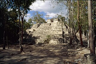
The site

Balberta was a fortified site controlling a wide area, which it probably came to dominate through a process of aggressive warfare. [3] The site has been investigated extensively by Frederick J. Bove. [14] The centre of the site consists of a number of mounds built upon a large platform. [15] The architectural style of the site shows a continuation of local tradition consisting of plazas with aligned structures that dates as far back as the Middle Preclassic, with some adaptation to the changing political situation in the region which necessitated the construction of defenses around the site core. [16] The site core consists of 22 structures occupying an area of 18 hectares (1,900,000 sq ft). [17]

The site core was defended by a wall starting at the southwest corner of Structure 1, surrounding the Mound Plaza on three sides, standing from 3 and 4 metres (9.8 and 13.1 ft) tall. Additionally, a deep ditch marks the east side of the site core, formed by redirecting a natural watercourse. [18]

A 6-metre (20 ft) wide causeway started near Structure 3 and ran eastwards to a group of small structures. [19]

Four projectile points were recovered from the Balberta site core that were fashioned from grey obsidian originating in central Mexico, three from Zaragoza in Puebla and one from Otumba in Mexico State. [8] A number of burials at the site had small jade beads placed inside the mouth of the interred individual. [20] More than 400 ceramic effigies of cocoa beans have been recovered during archaeological excavations of the site core. [21]

Archaeologists have recovered 124 pieces of green obsidian from the site, most of which were blade fragments. The majority of the green obsidian artifacts were found in Structure 1, with 65% of them being contained in four caches in the structure. [22]

During investigations carried out between 1984 and 1987, 26 burials were excavated, of which 23 were found under domestic structures. 24 of the burials were oriented east–west with the skull towards the west; the remaining 2 burials were oriented north–south with the skull to the north. The majority of the burials were covered with red pigment. [23]

The Mound Plaza is a 2-metre (6.6 ft) high platform measuring 360 by 200 metres (1,180 by 660 ft) supporting 16 structures arranged in five rows. The westernmost row of structures is the only row containing Terminal Preclassic material in its fill, for which reason it is considered to be the original area of occupation at Balberta. This row consists of four structures; the rest consist of three structures each. [19]

Structure 1 or the Great Platform is found immediately to the north of the Mound Plaza. [17] It has sloping sides and a very wide upper surface. It underwent three main phases of construction. The earliest version of the structure consisted of a low platform of compacted clay, only 40 centimetres (16 in) high. Its exact dimensions are unknown but it was not as large as in the later phases. The second phase involved a major construction effort, the platform being expanded to 3 metres (9.8 ft) in height and covering almost the same surface area as the final version of the platform. This final version was built up by using layers of compacted clay separated by thin layers of sand and soft clay. The final dimensions of the platform were 190 by 160 metres (620 by 520 ft), divided between two levels known as the Low Platform and the High Platform, the higher level being 7 metres (23 ft) high and the lower part being 4 metres (13 ft) high. The higher section of the platform consists of 76,800 cubic metres (2,710,000 cu ft) of fill deposited in a single construction phase. It is topped by various low mounds that have been identified as elite residences. The lower section was non-residential in nature although elite burials were discovered as well as ceremonial offerings. [17] [18] One of these elite burials was accompanied by a green obsidian projectile point, a black obsidian spear point, ceramic earspools, an urn, a spindle whirl and a ceramic bowl. [22]

Structure 4 is located in the Mound Plaza. [16]

Structure 8 is also located in the Mound Plaza. [16]

Structure 10 occupies the centre of the Mound Plaza. It is the highest structure in the plaza and is a pyramid measuring 8 metres (26 ft) high and 68 metres (223 ft) across at the base. The structure had at least six phases of construction, each being built on top of the previous and with the earliest yet identified being 4 metres (13 ft) high. [19]

Structure 13 is located in the Mound Plaza. It demonstrates several construction phases. [16]

Structure 21 is the second largest structure at the site, after Structure 1. [18]

See also

Notes

  1. Arroyo 2003, p. 34.
  2. Bove 1994, p. 39.
  3. 1 2 Bove & Medrano Busto 2003, pp. 49-50.
  4. Bove 1994, p. 40. Medrano Busto 1994, p. 47.
  5. 1 2 Sharer 2000, pp. 468-469.
  6. 1 2 3 4 5 6 7 Sharer & Traxler 2006, pp. 289, 292.
  7. 1 2 3 4 5 6 7 Bove & Medrano Busto 2003, pp. 50-51.
  8. 1 2 Bove & Medrano Busto 2003, p. 53.
  9. 1 2 Lou P. 1994, p.53.
  10. Bove 1994, p. 39. Bove & Medrano Busto 2003, p. 46.
  11. Medrano Busto 1994, p. 47. Lou P. 1994, p.53.
  12. 1 2 Lou P. 1994, p.54.
  13. 1 2 Bove & Medrano Busto 2003, pp. 72-73.
  14. Adams 2000, p. 35.
  15. Herman 1994, p. 42.
  16. 1 2 3 4 Medrano Busto 1994, p. 51.
  17. 1 2 3 Medrano Busto 1991, p. 53.
  18. 1 2 3 Medrano Busto 1994, p. 49.
  19. 1 2 3 Medrano Busto 1994, p. 50.
  20. Bove & Medrano Busto 2003, p. 60.
  21. Herman 1994, p. 44.
  22. 1 2 Spence 1996, p. 26.
  23. Arroyo 1994, p.64.

Related Research Articles

<span class="mw-page-title-main">Takalik Abaj</span> Pre-Columbian archaeological site in Guatemala

Tak'alik Ab'aj is a pre-Columbian archaeological site in Guatemala. It was formerly known as Abaj Takalik; its ancient name may have been Kooja. It is one of several Mesoamerican sites with both Olmec and Maya features. The site flourished in the Preclassic and Classic periods, from the 9th century BC through to at least the 10th century AD, and was an important centre of commerce, trading with Kaminaljuyu and Chocolá. Investigations have revealed that it is one of the largest sites with sculptured monuments on the Pacific coastal plain. Olmec-style sculptures include a possible colossal head, petroglyphs and others. The site has one of the greatest concentrations of Olmec-style sculpture outside of the Gulf of Mexico.

<span class="mw-page-title-main">Tazumal</span> Archaeological site in El Salvador

Tazumal is a pre-Columbian archeological site in Chalchuapa, El Salvador. Tazumal is an architectural complex within the larger area of the ancient Mesoamerican city of Chalchuapa, in western El Salvador. The Tazumal group is located in the southern portion of the Chalchuapa archaeological zone. Archaeologist Stanley Boggs excavated and restored the Tazumal complex during the 1940s and 1950s.

<span class="mw-page-title-main">Río Azul</span> Mayan archaeological site in Petén Department, Guatemala

Río Azul is an archaeological site of the Pre-Columbian Maya civilization. It is the most important site in the Río Azul National Park in the Petén Department of northern Guatemala, close to the borders of Mexico and Belize. Río Azul is situated to the southeast of the Azul river and its apogee dates to the Early Classic period.

<span class="mw-page-title-main">Tres Islas</span>

Tres Islas is a small pre-Columbian Maya archaeological site 20 kilometres (12 mi) north of Cancuen in Petén Department, northern Guatemala. The site has been dated to the Late Preclassic and Late Classic periods of Mesoamerican chronology. The main feature of the site is a group of three Maya stelae and an altar, arranged in a way that mimics an E-Group Maya astronomical complex.

<span class="mw-page-title-main">Kinal</span> Mayan archaeological site in Petén Department, Guatemala

Kinal is a major pre-Columbian Maya archaeological site in the Petén Department of the modern-day Petén Department of northern Guatemala. The major occupational phase for the site dates from the Late Classic period of Mesoamerican chronology, with evidence for a substantial and expansionary building program dating from the first half of the 8th century AD. Kinal was discovered in the 1960s by archaeologist Ian Graham while he was carrying out an archaeological survey of the region, although no excavations were undertaken at the site at that time.

<span class="mw-page-title-main">Topoxte</span>

Topoxte is a pre-Columbian Maya archaeological site in the Petén Basin in northern Guatemala with a long occupational history dating as far back as the Middle Preclassic. As the capital of the Kowoj Maya, it was the largest of the few Postclassic Mesoamerican sites in the area. Topoxte is located on an island on Yaxha Lake across from the important Classic period center of Yaxha.

<span class="mw-page-title-main">Yaxha</span> Archeological site

Yaxha is a Mesoamerican archaeological site in the northeast of the Petén Basin region, and a former ceremonial centre and city of the pre-Columbian Maya civilization. Yaxha was the third largest city in the region and experienced its maximum power during the Early Classic period.

<span class="mw-page-title-main">El Tintal</span>

El Tintal is a Maya archaeological site in the northern Petén region of Guatemala, about 25 kilometres (16 mi) northeast of the modern-day settlement of Carmelita, with settlement dating to the Preclassic and Classic periods. It is close to the better known sites of El Mirador, to which it was linked by causeway, and Nakbé. El Tintal is a sizeable site that includes some very large structures and it is one of the four largest sites in the northern Petén; it is the second largest site in the Mirador Basin, after El Mirador itself. El Tintal features monumental architecture dating to the Middle Preclassic similar to that found at El Mirador, Nakbé and Wakna. Potsherds recovered from the site date to the Late Preclassic and Early Classic periods, and construction continued at the site in the Late Classic period.

<span class="mw-page-title-main">Bilbao (Mesoamerican site)</span>

Bilbao is a Mesoamerican archaeological site about 1 mile (1.6 km) from the modern town of Santa Lucía Cotzumalguapa in the Escuintla department of Guatemala. The site lies among sugar plantations on the Pacific coastal plain and its principal phase of occupation is dated to the Classic Period. Bilbao was a major centre belonging to the Cotzumalhuapa culture with its main occupation dating to the Late Classic. Bilbao is the former name of the plantation on which the site lies and from which it has derived its name.

<span class="mw-page-title-main">Montana (Mesoamerican site)</span>

Montana is a Mesoamerican archaeological site on the Pacific coastal plain of southern Guatemala. It is located in the department of Escuintla, near Balberta, and is one of the largest Mesoamerican archaeological sites on the Pacific Coast of Guatemala.

<span class="mw-page-title-main">Bejucal (Mesoamerican site)</span>

Bejucal is a Maya archaeological site in the Petén Department of Guatemala. It is located 7 kilometres (4.3 mi) northeast of El Zotz and was subservient to that city. The site is thought to date to the second half of the 4th century AD, in the Early Classic period.

<span class="mw-page-title-main">Balamku</span>

Balamku is a small Maya archaeological site located in the Mexican state of Campeche. It features elaborate plaster facades dating to the Early Classic period. It has one of the largest surviving stucco friezes in the Maya world. Balamku was first occupied from around 300 BC. Its most important buildings date from AD 300–600.

Punta de Chimino is a Maya archaeological site in the Petexbatún region of the department of Petén in Guatemala. Occupation at the site dates to the Preclassic and Classic periods of Mesoamerican chronology. Punta de Chimino experienced a population surge in the Late Preclassic, followed by a reduction in occupation levels in the Early Classic and another increase in the Terminal Classic when the city became one of the few population centres to survive the political disintegration of the Petexbatún region after the collapse of the kingdom based at Dos Pilas. The neighbouring city of Seibal on the Pasión River appears to have intervened at Punta de Chimino at this time and to have politically dominated the smaller site.

<span class="mw-page-title-main">Itzan</span>

Itzan is a Maya archaeological site located in the municipality of La Libertad in the Petén Department of Guatemala. Various small structures at the site were destroyed in the 1980s during oil exploration activities by Sonpetrol and Basic Resources Ltd, prompting rescue excavations by archaeologists. In spite of its small size, the site appears to have been the most politically important centre in its area, as evidenced by its unusually large quantity of monuments and the size of its major architecture.

<span class="mw-page-title-main">Triadic pyramid</span> Style in Mayan architecture

Triadic pyramids were an innovation of the Preclassic Maya civilization consisting of a dominant structure flanked by two smaller inward-facing buildings, all mounted upon a single basal platform. The largest known triadic pyramid was built at El Mirador in the Petén Basin of Guatemala; it covers an area six times as large as that covered by Tikal Temple IV, which is the largest pyramid at that city. The three superstructures all have stairways leading up from the central plaza on top of the basal platform. Triadic pyramid structures are found at early cities in the Maya lowlands.

<span class="mw-page-title-main">La Blanca, Peten</span> Archaeological site in Petén, Guatemala

La Blanca is a Maya pre-Columbian Mesoamerican archaeological site in the municipality of Melchor de Mencos in the northern Petén Department of Guatemala. It has an occupation dating predominantly from the Middle Preclassic period of Mesoamerican chronology. This site belongs to the later period of the Mokaya culture. The site is located in the lower reaches of the Mopan River valley and features a large acropolis complex. Activity at the site has been dated as far back as the Early Classic, with principal occupation of the site occurring in the Late Classic period, although some level of occupation continued into the Early Postclassic.

<span class="mw-page-title-main">Plaza of the Seven Temples</span>

The Plaza of the Seven Temples is an architectural complex in the ruins of the Maya city of Tikal, in the Petén Department of northern Guatemala. It is to the south of Temple III and to the west of the South Acropolis; it is 300 metres (980 ft) to the southwest of the Great Plaza. The Plaza of the Seven Temples is situated directly to the east of the Mundo Perdido Complex and takes its name from a row of seven small temples dating to the Late Classic Period. The plaza has a surface area of approximately 25,000 square metres (270,000 sq ft), making it one of the three largest plazas in the city.

<span class="mw-page-title-main">Ixtonton</span>

Ixtonton is a Maya archaeological site in the department of Petén in northern Guatemala. It is located in the northwestern portion of the Maya Mountains in the municipality of Dolores. The ruins are situated approximately 2 kilometres (1.2 mi) east of the town of Dolores itself. Ixtonton was the capital city of one of the four Maya kingdoms in the upper Mopan Valley. The site was occupied from the Late Preclassic period through to the Terminal Classic, with some evidence of continued activity into the Postclassic. For the majority of its history Ixtonton was the most important city in the upper Mopan Valley, with its only rivals emerging in the Late Classic. The acropolis at Ixtonton is laid out around two plazas on top of an artificially modified karstic hill.

<span class="mw-page-title-main">Guaytán</span>

Guaytán is an archaeological site of the Maya civilization in the municipality of San Agustín Acasaguastlán, in the department of El Progreso, in Guatemala. It is the most important pre-Columbian archaeological site of the middle drainage of the Motagua River.

<span class="mw-page-title-main">San Clemente, El Petén</span> Mayan ruin in Guatemala

San Clemente is a ruin of the ancient Maya civilization in Guatemala. Its main period of occupation dates to the Classic period of Mesoamerican chronology. The ruins were first described in the late 19th century, before being visited by a number of investigators in the early part of the 20th century.

References

14°5′4″N90°58′11″W / 14.08444°N 90.96972°W / 14.08444; -90.96972