Seibal, known as El Ceibal in Spanish, is a Classic Period archaeological site of the Maya civilization located in the northern Petén Department of Guatemala, about 100 km SW of Tikal. It was the largest city in the Pasión River region.

Tak'alik Ab'aj is a pre-Columbian archaeological site in Guatemala. It was formerly known as Abaj Takalik; its ancient name may have been Kooja. It is one of several Mesoamerican sites with both Olmec and Maya features. The site flourished in the Preclassic and Classic periods, from the 9th century BC through to at least the 10th century AD, and was an important centre of commerce, trading with Kaminaljuyu and Chocolá. Investigations have revealed that it is one of the largest sites with sculptured monuments on the Pacific coastal plain. Olmec-style sculptures include a possible colossal head, petroglyphs and others. The site has one of the greatest concentrations of Olmec-style sculpture outside of the Gulf of Mexico.
Ixlu is a small Maya archaeological site that dates to the Classic and Postclassic Periods. It is located on the isthmus between the Petén Itzá and Salpetén lakes, in the northern Petén Department of Guatemala. The site was an important port with access to Lake Petén Itzá via the Ixlu River. The site has been identified as Saklamakhal, also spelt Saclemacal, a capital of the Kowoj Maya.

Machaquila is a major ruined city of the Maya civilization in what is now the El Peten department of Guatemala.

Río Azul is an archaeological site of the Pre-Columbian Maya civilization. It is the most important site in the Río Azul National Park in the Petén Department of northern Guatemala, close to the borders of Mexico and Belize. Río Azul is situated to the southeast of the Azul river and its apogee dates to the Early Classic period.
Tamarindito is an archaeological site of the Maya civilization located along an escarpment in the Petén department of Guatemala. The city was the capital of the Petexbatún region of the southwestern Petén during the Early Classic period but was displaced by the newly founded conquest state of Dos Pilas. In the 8th century Tamarindito turned on its new overlord and defeated it. After the destruction of the Dos Pilas kingdom the region descended into chaos and suffered rapid population decline. The city was all but abandoned by the 9th century AD.

Ixkun is a pre-Columbian Maya archaeological site, situated in the Petén Basin region of the southern Maya lowlands. It lies to the north of the town of Dolores, in the modern-day department of Petén, Guatemala. It is a large site containing many unrestored mounds and ruins and is the best known archaeological site within the municipality of Dolores.

Yaxha is a Mesoamerican archaeological site in the northeast of the Petén Basin region, and a former ceremonial centre and city of the pre-Columbian Maya civilization. Yaxha was the third largest city in the region and experienced its maximum power during the Early Classic period.
Altar de Sacrificios is a ceremonial center and archaeological site of the pre-Columbian Maya civilization, situated near the confluence of the Pasión and Salinas Rivers, in the present-day department of Petén, Guatemala. Along with Seibal and Dos Pilas, Altar de Sacrificios is one of the better-known and most intensively-excavated sites in the region, although the site itself does not seem to have been a major political force in the Late Classic period.

El Tintal is a Maya archaeological site in the northern Petén region of Guatemala, about 25 kilometres (16 mi) northeast of the modern-day settlement of Carmelita, with settlement dating to the Preclassic and Classic periods. It is close to the better known sites of El Mirador, to which it was linked by causeway, and Nakbé. El Tintal is a sizeable site that includes some very large structures and it is one of the four largest sites in the northern Petén; it is the second largest site in the Mirador Basin, after El Mirador itself. El Tintal features monumental architecture dating to the Middle Preclassic similar to that found at El Mirador, Nakbé and Wakna. Potsherds recovered from the site date to the Late Preclassic and Early Classic periods, and construction continued at the site in the Late Classic period.
Bejucal is a Maya archaeological site in the Petén Department of Guatemala. It is located 7 kilometres (4.3 mi) northeast of El Zotz and was subservient to that city. The site is thought to date to the second half of the 4th century AD, in the Early Classic period.
Balamku is a small Maya archaeological site located in the Mexican state of Campeche. It features elaborate plaster facades dating to the Early Classic period. It has one of the largest surviving stucco friezes in the Maya world. Balamku was first occupied from around 300 BC. Its most important buildings date from AD 300–600.
Punta de Chimino is a Maya archaeological site in the Petexbatún region of the department of Petén in Guatemala. Occupation at the site dates to the Preclassic and Classic periods of Mesoamerican chronology. Punta de Chimino experienced a population surge in the Late Preclassic, followed by a reduction in occupation levels in the Early Classic and another increase in the Terminal Classic when the city became one of the few population centres to survive the political disintegration of the Petexbatún region after the collapse of the kingdom based at Dos Pilas. The neighbouring city of Seibal on the Pasión River appears to have intervened at Punta de Chimino at this time and to have politically dominated the smaller site.
Itzan is a Maya archaeological site located in the municipality of La Libertad in the Petén Department of Guatemala. Various small structures at the site were destroyed in the 1980s during oil exploration activities by Sonpetrol and Basic Resources Ltd, prompting rescue excavations by archaeologists. In spite of its small size, the site appears to have been the most politically important centre in its area, as evidenced by its unusually large quantity of monuments and the size of its major architecture.
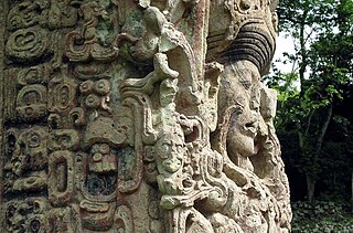
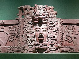
Maya stelae are monuments that were fashioned by the Maya civilization of ancient Mesoamerica. They consist of tall, sculpted stone shafts and are often associated with low circular stones referred to as altars, although their actual function is uncertain. Many stelae were sculpted in low relief, although plain monuments are found throughout the Maya region. The sculpting of these monuments spread throughout the Maya area during the Classic Period, and these pairings of sculpted stelae and circular altars are considered a hallmark of Classic Maya civilization. The earliest dated stela to have been found in situ in the Maya lowlands was recovered from the great city of Tikal in Guatemala. During the Classic Period almost every Maya kingdom in the southern lowlands raised stelae in its ceremonial centre.

Sacul is an archaeological site of the Maya civilization located in the upper drainage of the Mopan River, in the Petén department of Guatemala. The city occupied an important trade route through the Maya Mountains. The main period of occupation dates to the Late Classic Period. In the late 8th century AD through to the early 9th century, Sacul was one of the few kingdoms in the southeastern Petén region to use its own Emblem Glyph, together with Ixtutz and Ucanal.
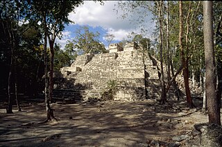
Tikal Temple III, also known as the Temple of the Jaguar Priest, was one of the principal temple pyramids at the ancient Maya city of Tikal, in the Petén Department of modern Guatemala. The temple stands approximately 55 metres (180 ft) tall. The summit shrine of Temple III differs from those of the other major temples at Tikal in that it only possesses two rooms instead of the usual three. The pyramid was built in the Late Classic Period, and has been dated to 810 AD using the hieroglyphic text on Stela 24, which was raised at the base of its access stairway. Stela 24 is paired with the damaged Altar 6, in a typical stela-altar pair.

Ixtonton is a Maya archaeological site in the department of Petén in northern Guatemala. It is located in the northwestern portion of the Maya Mountains in the municipality of Dolores. The ruins are situated approximately 2 kilometres (1.2 mi) east of the town of Dolores itself. Ixtonton was the capital city of one of the four Maya kingdoms in the upper Mopan Valley. The site was occupied from the Late Preclassic period through to the Terminal Classic, with some evidence of continued activity into the Postclassic. For the majority of its history Ixtonton was the most important city in the upper Mopan Valley, with its only rivals emerging in the Late Classic. The acropolis at Ixtonton is laid out around two plazas on top of an artificially modified karstic hill.

A twin-pyramid complex or twin-pyramid group was an architectural innovation of the Maya civilization of ancient Mesoamerica. Twin-pyramid complexes were regularly built at the great city of Tikal in the central Petén Basin of Guatemala to celebrate the end of the 20-year kʼatun cycle of the Maya Long Count Calendar. A twin-pyramid complex has been identified at Yaxha, a large city that was 30 kilometres (19 mi) to the southeast of Tikal. Another has been mapped at Ixlu, and Zacpeten appears also to possess at least one twin-pyramid complex and possibly two. These examples outside of Tikal itself indicate that their cities were closely linked to Tikal politically.