![]() The main plaza of Aguateca showing a large stone stela | |
Region | Petén Department, Guatemala |
---|
Aguateca is a Maya site located in northern Guatemala's Petexbatun Basin, in the department of Petén. The first settlements at Aguateca date to the Late Preclassic period (300 BC - AD 350). The center was occupied from about 200 B.C. until about 800 A.D., when the city was attacked and ransacked. Because the city was rapidly abandoned by its population, Pompeii-style assemblages were left scattered on the floors of elite residences. Horizontal excavation of these residences has revealed ancient elite activity and household level craft production areas. [1] Aguateca sits on top of a 90 metres (300 ft) tall limestone bluff, creating a highly defensible position. This steep escarpment overlooks Petexbatun Lagoon in the Southwestern Guatemalan lowlands and is accessible by boat. [2] There is an extensive system of defensive walls that surrounds the city, reaching over 3 miles (4.8 km) in length. [3] Its center consisted on the Palace Group, which was probably a royal residential compound, and the Main Plaza. These monumental complexes were connected by a causeway, along which was a densely occupied elite residential area. During the reign of Tan Te' K'inich the city was invaded and burned. The city was completely abandoned around 830 AD. A 6-metre (20 ft) tall temple at the site was left unfinished, the centre of the city was destroyed by fire, valuables were left scattered in elite residences, and ceramics were left in their original domestic positions, all of which demonstrate the sudden abandonment of the city. [2] [4] The ruins of Aguateca are considered to be among the best preserved in Guatemala. [5]
Aguateca and the nearby city of Dos Pilas were the twin capitals of a powerful dynasty claiming descent from the rulers of Tikal. [6] Around 700 AD, it appears that Dos Pilas Rulers 3 and 4 were responsible for shifting the focus of the dynasty from Dos Pilas to Aguateca, as can be determined from stelas and monuments. [7] In 761 AD, the rulers of Dos Pilas appear to have abandoned their city and relocated to Aguateca. Aguateca became a large, densely populated city, with a higher density of structures than most other lowland Maya sites. It is possible that the population of Aguateca migrated from the Pasion region, but it is likely there was a large population from other regions as well. The influx of people was probably a result of the political influence of the dynasty. The development of a new center requires a substantial labor force to construct temples, palaces, and causeways. For the royal family and elites securing a controllable population was essential. [8] [9] [10]
The structural complexes of this ancient Mayan site have provided archaeologists with invaluable information about the societal composition at Aguateca. This includes the significance and role of different social classes, their placement in society, and their daily routines. In addition to this, households, as the most basic socioeconomic units, interacted dynamically with larger social, economic, and political institutions. The examination of these aspects at Aguateca is critical for understanding various aspects of human societies and behavior. [2]
In most traditional societies, like Aguateca, what we call private and public merge inseparably, in contrast to modern societies, in which the division between "home" and "work" is relatively common. [2] Houses in the elite residential area of Aguateca commonly consist of three main rooms and smaller additions. These included numerous domestic objects including serving vessels, grinding stones, and a variety of stone tools. Obsidian blades, probably used for bloodletting, were also found, as well as stone mortars for pigment reparation. The central rooms appear to have served as locations to receive visitors, perform scribe work, and store ritual objects as well as food. The presence of mano and metate in one of the main rooms of these complexes also indicates that food preparation took place here. In addition, excavators found seven bone needles and seven spindle whorls in one of the rooms. This suggests that textile production occurred in or in front of this room, most likely a task undertaken by women. The residents of an elite structure clearly conducted a wide range of mundane activities, including the storage, preparation, and consumption of food. As noted, these residences were also spaces for political gatherings and artistic production. A male resident may have used the central room for meetings and one of the side rooms for scribal and artistic work, whereas the other room was most likely associated with the female. [2] Each residence was multi-purposeful, and there have been no structures found that were solely dedicated to food storage within the elite residential groups or the royal palace. This indicates that food storage was not centralized or controlled. Because of this, differences in food storage capacity and food processing may reflect differences in household size or even differences in economic status and access to sources. [11] An elite Maya man could have conducted various activities, such as stone knapping, carving wood, shell, or bone, as well as administrative, diplomatic, and ritual duties in and outside the residence. An elite Maya woman may have engaged in different kinds of artistic creation and craft production, in addition to other domestic activities. Classic elite men and women possessed multiple social identities and roles. [12]
The Classic Maya strongly emphasized the theatrical performance and visibility of rulers. The large plaza at Aguateca, like other Classic Maya centers, was designed to accommodate a large number of individuals. These plazas held the majority of the community members on ceremonial occasions. Residents made a significant effort to secure spaces for mass spectacles by creating plazas outside of core areas and constructing large causeways. Prominent representations of rulers on stone monuments were also placed in plazas. Theatrical events probably held together a Maya community around the ruler and royal court. The presence of plazas of varying sizes suggests that theatrical events also divided the community, separating those who were allowed to participate in exclusive performance from the less privileged. [13]
The overall site layout, architectural configurations, storage of objects, and post-abandonment treatment all point to the unique qualities of the Palace Group as the royal palace complex. These buildings also served administrative functions with the central rooms used as settings for royal audience and other political meetings. The configuration of this royal palace complex suggests that the ruler maintained a certain level of visibility. For example, meetings held in one of the Palace Group structures were visible to those who were not allowed in. The prominence of meeting scenes in Maya ceramic paintings suggests that certain gatherings in royal palaces were meant to be witnessed. It appears that before the final attack on Aguateca took place, the royal family cleaned out the rooms of the palace and left the center. [14]
One structure that has been discovered has been identified as an unfinished temple. It is believed that it was still in the process of construction when it was attacked and abandoned at the beginning of the 9th century. Its discovery has provided valuable information on Maya building methods and processes, as well as the likelihood for specialization. It is possible that construction labour was organized into different groups, such as workers carrying rocks to the site, stone cutters quarrying blocks for dressed stone, masons or plaster workers setting stones with mortar, and stone sculptors carving monuments. All of these people worked side by side, and elite architects or supervisors most likely coordinated the tasks of various workers. [8] [15]
A significant portion of Maya elites, both men and women, engaged in artistic creation and craft production at Aguateca, and they were often involved in independent and attached production. Artistic and craft production appears to have been a common pursuit among classic Maya elites at Aguateca, including courtiers of the highest rank and even members of the royal family. They manufactured not only luxury goods and weaponry but also utilitarian items for consumption both within and outside the household. Items produced included wood carvings and hide or leather goods. Because of this, several kinds of craft production overlapped in various households. At the same time, particular households and individuals emphasized specific artistic creation and craft activities. One household might carve stelae for the ruler, while another might have an emphasis on shell and bone objects of high symbolic value. It is likely that elite women actively participated in these types of production, engaging in stone carving in collaboration with noble men. Artistic creation, as well as the garnering of ideological, religious, and esoteric production knowledge, were important in exclusionary tactics and elite identity. [12] [1] Some of these elite art pieces were found burned after the abandonment of Aguateca, with pieces representing what archaeologists call "The Jester God" being found in one of the elite residences, signifying the importance of art creation among the elite. [16]
Obsidian was a highly valued material in Classic Maya society, and possession of it was indicative of high status. The rulers of Aguateca controlled the main access to obsidian in the city while the procurement and distribution of obsidian may have been administered by the royal court of the Aguateca dynasty as part of its political economy. Both the rulers of Aguateca and the elite scribes/artists had a larger number of stronger and more substantial obsidian crafted blades than those who lived in smaller residences. The presence of obsidian also indicates that the Classic Maya at Aguateca were not isolated from other regions but participated in long distance trade to obtain the material. [17]
Production of goods from animal products for the community and rulers seems to have been common. All members of the community were involved in animal related craft production, but some aspects of this crafting were only carried out in specific households. Activities included meat/hide production and initial bone-tool production. [1] Some animals were used as luxury goods and foods, access to which was differentially available on the basis of social rank or authority. The upper class had greater access to animal sources that were considered to be more ritual or exotic. Such species included marine shells (for decoration) and wild cats such as jaguars, margays, and ocelots (used for pelts, teeth, and claws). Non-exotic animals were also differentially available as foods and tools. Dominant species for consumption at Aguateca include white-tailed deer, river turtles, dog, agouti, paca, peccaries, as well as large birds and riverine fish. [18]
The Main Plaza of Aguateca contained numerous stone monuments and provided an adequate environment for theatrical performances. [17] Theatrical performances not only communicate pre-existing ideas but also define political reality as it is experienced by participants. Theatrical events constitute a critical process of integration and conflict and have particularly significant effects on the maintenance and transformation of societies. The performances of rulers, which is depicted on stone monuments, involved a large audience. This makes the Main Plaza at Aguateca highly significant because its use as a theatrical space was a primary concern in the design of the city. These events gave physical reality to the community and counteracted the tendencies of non-elite populations to move away from the center of the city. The elite may have taken advantage of these performances to advance their political agendas, but they were at the same time under constant evaluation by viewers. Theatrical events set the stage for creation and imposition of power relations and associated ideologies, as well as resistance to and subversion of them. [13]
In order to be able to produce the goods and materials that they did, the community of Aguateca had to create the tools they used for production. Some of these tools included manos and metates, tools utilized for grinding, with manos typically being used for the preparation of corn, and metates being used to grind other materials down into smaller quantities. [19] Some animal products were also used as tools, such as the bones of deer assisted in the manufacturing of lithic tools and burnishing. [19] The people of Aguateca were able to create these tools that they used to create many other of the artifacts found at the archaeological site, and provide answers as to how the production of materials and goods was organized and carried out in their society.
The Main Chasm is a naturally formed deep fracture of limestone karst running NE-SW through the middle of the Aguateca site. It measures approximately 850 m long, 10–70 m deep and 1,5 – 15 m wide. [20] Embodying the maya conception of mountain-cave, [21] it has strong evidence of a variety of ritual practices. This suggests that chasms, like caves, represent potent cosmological and religious places where ancestral and supernatural spirits can be reached. The features and natural phenomena observed at the Main Chasm at Aguateca provide a window into the complex manipulation of the transformative properties of the elements and their significance. At Aguateca, within the interiors of the earth where the wind blows clouds onto the hill from the depths of the chasm, wind instruments were played and fires were burned. It is possible these fires contained copal incense which would have formed black smoke reminiscent of rain clouds, with the hopes of bringing rain. Notably, two of the elements air (wind) and water (rain), are intricately linked according to Maya beliefs. Water, as an enduring element of life, was materialized in the form of rain ceremonies, layered with meanings that ranged from sufficient rainfall to dynastic prosperity and power. [22] The toponymic glyph of Aguateca represents the chasm. [23]
The subsistence environment at Aguateca, like at other Classic Maya sites, was limited by shallow, sloped soils and unpredictable weather patterns until their collapse. Based on changes in stable carbon isotope ratios of soil, we are able to determine the ancient presence of C4 plant growth and maize. The ancient Maya of Aguateca probably adapted to their environment by exploiting ideal areas for agriculture. As a result, it is likely that maize was grown in the seasonal wetlands adjacent to the site. Natural "rejollada" karst features, "toeslip" soils, and seasonally inundated wetlands were important soil resources to the ancient Maya because the soils there were deep and fertile. Stepped slopes of the rejolladas may have acted as natural terraces. This was also probably the site of frequent maize cultivation and may have been politically important. [24]
Both the royal family and elite scribes/artists at Aguateca used spear and dart points for "inter-group human conflict" as well as for artistic and craft production under enemy threat. The ruler and elite were also warriors, and owning these weapons and participating in warfare established and perpetuated their supremacy. Spear and dart points were more important than the bow and arrow, but notches in these points do indicate that the bow and arrow was in use. Inter-valley conflict may have been a crucial factor that lead to the development of Classic Maya complex societies such as Aguateca. This warfare had a fundamental effect on society, and is what ultimately led to the demise of Aguateca. [25]
Although inter-group conflict, climate changes, and environmental degradation began to cause social upheaval towards the end of the reign of Aguateca, the ultimate destruction of the center was a result of warfare. [7] [15] Around 800 A.D. Aguateca appears to have been attacked by enemies. A series of defensive walls that were hastily constructed towards the end of the Late Classic period were probably in response to the escalation of warfare in the region. The elite residential area near the royal palace was burned, and residents fled or were taken away, leaving most of their belongings behind. The attacking army did not stay in the center, and soon the entire city was abandoned. Elaborately built structures, such as the Palace Group, contained highly valuable goods, such as greenstone beads, carved alabaster, and shell ornamentation. This further supports the conclusion that the city was abandoned rapidly. Excavations at the Palace Group suggest that the royal family evacuated the center before the attack and anticipated to return, but it appears that members of the elite remained. Areas outside the center were abandoned gradually, probably right after the destruction of the city. The inhabitants of these areas carried away most of their belongings to their next residences. Because of the pattern of destruction and abandonment, it is likely that the ruling elite of Aguateca was the primary focus of battle. The enemies aimed to terminate Aguateca as a political and economic power and they succeeded. [26] The drastic fall of Aguateca is very similar to the situation in Pompeii, which provides us with a wealth of evidence today. Moments of classic Maya lives were frozen in the rich assemblages of objects left in burned structures. This provides information regarding domestic activities, household organization, and political interactions of the Classic Maya at Aguateca. [8] [2] [15] [27]
Seibal, known as El Ceibal in Spanish, is a Classic Period archaeological site of the Maya civilization located in the northern Petén Department of Guatemala, about 100 km SW of Tikal. It was the largest city in the Pasión River region.
Mesoamerican pyramids form a prominent part of ancient Mesoamerican architecture. Although similar in some ways to Egyptian pyramids, these New World structures have flat tops and stairs ascending their faces. The largest pyramid in the world by volume is the Great Pyramid of Cholula, in the east-central Mexican state of Puebla. The builders of certain classic Mesoamerican pyramids have decorated them copiously with stories about the Hero Twins, the feathered serpent Quetzalcoatl, Mesoamerican creation myths, ritualistic sacrifice, etc. written in the form of Maya script on the rises of the steps of the pyramids, on the walls, and on the sculptures contained within.
Use-wear analysis is a method in archaeology to identify the functions of artifact tools by closely examining their working surfaces and edges. It is mainly used on stone tools, and is sometimes referred to as "traceological analysis".
Maya society concerns the social organization of the Pre-Hispanic Maya, its political structures, and social classes. The Maya people were indigenous to Mexico and Central America and the most dominant people groups of Central America up until the 6th century.
Trade in Maya civilization was a crucial factor in maintaining Maya cities.
Tamarindito is an archaeological site of the Maya civilization located along an escarpment in the Petén department of Guatemala. The city was the capital of the Petexbatún region of the southwestern Petén during the Early Classic period but was displaced by the newly founded conquest state of Dos Pilas. In the 8th century Tamarindito turned on its new overlord and defeated it. After the destruction of the Dos Pilas kingdom the region descended into chaos and suffered rapid population decline. The city was all but abandoned by the 9th century AD.
La Joyanca is the modern name for a pre-Columbian Maya archaeological site located south of the San Pedro Martir river in the Petén department of Guatemala. It is east of the Maya site of La Florida (Namaan), now the modern town of El Naranjo on the Mexico-Guatemala border. The site was discovered in 1994 during the construction of the Xan-La Libertad oil pipeline in Guatemala. It was immediately recognized as an important, undiscovered Classic period Maya city and became the focus of an archaeological project. Directed by Charlotte Arnauld, Erik Ponciano, and Veronique Breuil, the La Joyanca project conducted excavations here between 1998 and 2003. Several members of this group have continued work at other related locations in the Northwest Peten, including the sites of Zapote Bobal and Pajaral, as part of the Proyecto Peten Noroccidente (PNO).
Nakum is a Mesoamerican archaeological site, and a former ceremonial center and city of the pre-Columbian Maya civilization. It is located in the northeastern portion of the Petén Basin region, in the modern-day Guatemalan department of Petén. The northeastern Petén region contains a good number of other significant Maya sites, and Nakum is one of the three sites forming the Cultural Triangle of "Yaxha-Nakum-Naranjo". Nakum is approximately 17 kilometres (10.6 mi) to the north of Yaxha and some 25 kilometres (15.5 mi) to the east of Tikal, on the banks of the Holmul River. Its main features include an abundance of visibly restored architecture, and the roof comb of the site's main temple structure is one of the best-preserved outside Tikal.
Altar de Sacrificios is a ceremonial center and archaeological site of the pre-Columbian Maya civilization, situated near the confluence of the Pasión and Salinas Rivers, in the present-day department of Petén, Guatemala. Along with Seibal and Dos Pilas, Altar de Sacrificios is one of the better-known and most intensively-excavated sites in the region, although the site itself does not seem to have been a major political force in the Late Classic period.
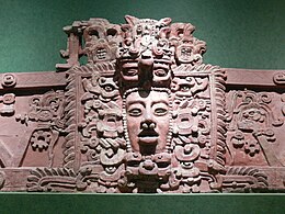
The Maya civilization was a Mesoamerican civilization that existed from antiquity to the early modern period. It is known by its ancient temples and glyphs (script). The Maya script is the most sophisticated and highly developed writing system in the pre-Columbian Americas. The civilization is also noted for its art, architecture, mathematics, calendar, and astronomical system.
Although the Maya were once thought to have been peaceful, current theories emphasize the role of inter-polity warfare as a factor in the development and perpetuation of Maya society. The goals and motives of warfare in Maya culture are not thoroughly understood, but scholars have developed models for Maya warfare based on several lines of evidence, including fortified defenses around structure complexes, artistic and epigraphic depictions of war, and the presence of weapons such as obsidian blades and projectile points in the archaeological record. Warfare can also be identified from archaeological remains that suggest a rapid and drastic break in a fundamental pattern due to violence.
Simon Martin is a British epigrapher, historian, writer and Mayanist scholar. He is best known for his contributions to the study and decipherment of the Maya script, the writing system used by the pre-Columbian Maya civilisation of Mesoamerica. As one of the leading epigraphers active in contemporary Mayanist research, Martin has specialised in the study of the political interactions and dynastic histories of Classic-era Maya polities. Since 2003 Martin has held positions at the University of Pennsylvania Museum of Archaeology and Anthropology where he is currently an Associate Curator and Keeper in the American Section, while teaching select courses as an Adjunct Associate Professor in the Department of Anthropology at the University of Pennsylvania.
Blue Creek is a riverine system and major archaeological site located in North-Western Belize, Central America. It is situated geographically on the Belize–Mexico border and then continues south across the Guatemala–Mexico border. The river is commonly known as the Río Azul or ‘Azul River’ in Spanish, which translates to ‘blue river’ or ‘blue creek’ in English.
Itzan is a Maya archaeological site located in the municipality of La Libertad in the Petén Department of Guatemala. Various small structures at the site were destroyed in the 1980s during oil exploration activities by Sonpetrol and Basic Resources Ltd, prompting rescue excavations by archaeologists. In spite of its small size, the site appears to have been the most politically important centre in its area, as evidenced by its unusually large quantity of monuments and the size of its major architecture.
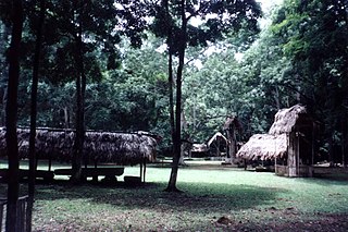
Maya cities were the centres of population of the pre-Columbian Maya civilization of Mesoamerica. They served the specialised roles of administration, commerce, manufacturing and religion that characterised ancient cities worldwide. Maya cities tended to be more dispersed than cities in other societies, even within Mesoamerica, as a result of adaptation to a lowland tropical environment that allowed food production amidst areas dedicated to other activities. They lacked the grid plans of the highland cities of central Mexico, such as Teotihuacán and Tenochtitlan. Maya kings ruled their kingdoms from palaces that were situated within the centre of their cities. Cities tended to be located in places that controlled trade routes or that could supply essential products. This allowed the elites that controlled trade to increase their wealth and status. Such cities were able to construct temples for public ceremonies, thus attracting further inhabitants to the city. Those cities that had favourable conditions for food production, combined with access to trade routes, were likely to develop into the capital cities of early Maya states.
Economy is conventionally defined as a function for production and distribution of goods and services by multiple agents within a society and/or geographical place An economy is hierarchical, made up of individuals that aggregate to make larger organizations such as governments and gives value to goods and services. The Maya economy had no universal form of trade exchange other than resources and services that could be provided among groups such as cacao beans and copper bells. Though there is limited archeological evidence to study the trade of perishable goods, it is noteworthy to explore the trade networks of artifacts and other luxury items that were likely transported together.
The history of Maya civilization is divided into three principal periods: the Preclassic, Classic and Postclassic periods; these were preceded by the Archaic Period, which saw the first settled villages and early developments in agriculture. Modern scholars regard these periods as arbitrary divisions of chronology of the Maya civilization, rather than indicative of cultural evolution or decadence. Definitions of the start and end dates of period spans can vary by as much as a century, depending on the author. The Preclassic lasted from approximately 3000 BC to approximately 250 AD; this was followed by the Classic, from 250 AD to roughly 950 AD, then by the Postclassic, from 950 AD to the middle of the 16th century. Each period is further subdivided:
Aguada Fénix is a large Preclassic Mayan ruin located in the state of Tabasco, Mexico, near the border with Guatemala was discovered by aerial survey using laser mapping, and announced in 2020. The flattened mound, nearly a mile in length and between 33 and 50 feet tall, is described as the oldest and the largest Mayan ceremonial site known. The monumental structure is constructed of earth and clay, and is believed to have been built from around 1000 BC to 800 BC.
The Preclassic or Formative Period of Belizean, Maya, and Mesoamerican history began with the Maya development of ceramics during 2000 BC – 900 BC, and ended with the advent of Mayan monumental inscriptions in 250 AD.
Media related to Aguateca at Wikimedia Commons