Related Research Articles

In the History of Mesoamerica, the stage known as the Paleo-Indian period is the era in the scheme of Mesoamerican chronology which begins with the very first indications of human habitation within the Mesoamerican region, and continues until the general onset of the development of agriculture and other proto-civilisation traits. The conclusion of this stage may be assigned to approximately 9000 BP, and the transition to the succeeding Archaic period is not a well-defined one.

Kaminaljuyu is a Pre-Columbian site of the Maya civilization located in Guatemala City. Primarily occupied from 1500 BC to 1200 AD, it has been described as one of the greatest archaeological sites in the New World—although the extant remains are distinctly unimpressive. Debate continues about its size, integration, and role in the surrounding Valley of Guatemala and the Southern Maya area.

Sir John Eric Sidney Thompson was a leading English Mesoamerican archaeologist, ethnohistorian, and epigrapher. While working in the United States, he dominated Maya studies and particularly the study of the Maya script until well into the 1960s.
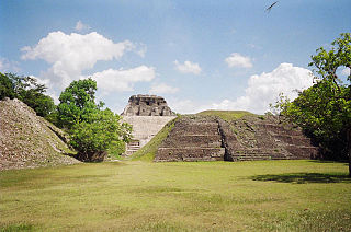
The Maya ruins of Belize include a number of well-known and historically important pre-Columbian Maya archaeological sites. Belize is considered part of the southern Maya lowlands of the Mesoamerican culture area, and the sites found there were occupied from the Preclassic until and after the arrival of the Spanish in the 16th century.

Mesoamerican pyramids form a prominent part of ancient Mesoamerican architecture. Although similar in some ways to Egyptian pyramids, these New World structures have flat tops and stairs ascending their faces. The largest pyramid in the world by volume is the Great Pyramid of Cholula, in the east-central Mexican state of Puebla. The builders of certain classic Mesoamerican pyramids have decorated them copiously with stories about the Hero Twins, the feathered serpent Quetzalcoatl, Mesoamerican creation myths, ritualistic sacrifice, etc. written in the form of Maya script on the rises of the steps of the pyramids, on the walls, and on the sculptures contained within.
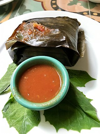
Ancient Maya cuisine was varied and extensive. Many different types of resources were consumed, including maritime, flora, and faunal material, and food was obtained or produced through strategies such as hunting, foraging, and large-scale agricultural production. Plant domestication concentrated upon several core foods, the most important of which was maize.

The Maya civilization was a Mesoamerican civilization that existed from antiquity to the early modern period. It is known by its ancient temples and glyphs (script). The Maya script is the most sophisticated and highly developed writing system in the pre-Columbian Americas. The civilization is also noted for its art, architecture, mathematics, calendar, and astronomical system.
The Pre-Columbian Belize history is the period from initial indigenous presence, across millennia, to the first contacts with Europeans - the Pre-Columbian or before Columbus period - that occurred on the region of the Yucatán Peninsula that is present day Belize.

Blue Creek is a riverine system and major archaeological site located in North-Western Belize, Central America. It is situated geographically on the Belize–Mexico border and then continues south across the Guatemala–Mexico border. The river is commonly known as the Río Azul or ‘Azul River’ in Spanish, which translates to ‘blue river’ or ‘blue creek’ in English.

The Preclassic period in Maya history stretches from the beginning of permanent village life c. 1000 BC until the advent of the Classic Period c. 250 AD, and is subdivided into Early, Middle, and Late. Major archaeological sites of this period include Nakbe, Uaxactun, Seibal, San Bartolo, Cival, and El Mirador.
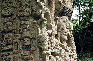
Maya stelae are monuments that were fashioned by the Maya civilization of ancient Mesoamerica. They consist of tall, sculpted stone shafts and are often associated with low circular stones referred to as altars, although their actual function is uncertain. Many stelae were sculpted in low relief, although plain monuments are found throughout the Maya region. The sculpting of these monuments spread throughout the Maya area during the Classic Period, and these pairings of sculpted stelae and circular altars are considered a hallmark of Classic Maya civilization. The earliest dated stela to have been found in situ in the Maya lowlands was recovered from the great city of Tikal in Guatemala. During the Classic Period almost every Maya kingdom in the southern lowlands raised stelae in its ceremonial centre.
Pusilhá is an archaeological site in Belize. The location of this Late Classic Maya urban complex, along the east and west flow of trade, made the city a major transfer point for economic activities in the whole region. In addition, the city gave archaeologists a historical view of a secondary Maya site. Large and extended excavation efforts have changed the overall picture of Maya social and political relationships between larger and smaller cities and challenged the prevailing view of conquest and absorption of smaller cities into the larger cities in the region. The research conducted at Pusilhá began in 1927 and continues to this day.
La Milpa is an archaeological site and an ancient Maya city within the Three River region of Northwest Belize bordering Mexico and Guatemala. La Milpa is located between the sites of Rio Azul and Lamanai. Currently, La Milpa lies within the nature preserve owned by the Programme for Belize, a non-profit organization. PfB acquired land for the preserve from the Coco-Cola Company, who purchased land in Belize in 1988 with the goals of tearing down the rainforest to create a citrus plantation, however donated the land to conservation and management project in 1990 and 1992. Following Caracol and Lamanai, La Milpa is the third largest site in Belize with the Main Plaza alone covering 18,000 square meters, making it one of the largest in the entire Maya region.
Baking Pot is a Maya archaeological site located in the Belize River Valley on the southern bank of the river, northeast of modern-day town of San Ignacio in the Cayo District of Belize; it is 6 kilometres (3.7 mi) downstream from the Barton Ramie and Lower Dover archaeological sites. Baking Pot is associated with an extensive amount of research into Maya settlements, community-based archaeology, and of agricultural production; the site possesses lithic workshops, and possible evidence of cash-cropping cacao as well as a long occupation from the Preclassic through to the Postclassic period.
Kʼaxob is an archaeological site of the Maya civilization located in Belize. It was occupied from about 800 B.C. to A.D. 900. The site is located in northern Belize in the wetlands of Pulltrouser Swamp in proximity to the Sibun River Valley in central Belize. Research has shown that Kʼaxob was occupied from the Late Preclassic Period to the Early Postclassic Period. This period in time and the site is characterized by specific ceramic types as well as agriculture and an increase in social stratification. Kʼaxob is a village site centered on two pyramid plazas and later grew in size during the Early Classic Period to the Late Classic Period. The site includes a number of household, mounds and plazas. Kʼaxob is mostly based on residential and household living but also has some ritualistic aspects.

Pacbitun is a Maya archaeological site located near the town of San Ignacio, Belize, in the Cayo District of west central Belize. The modern Maya name given to the site means “stone set in earth”, likely a reference to multiple fragments of stone monuments. The site, at about 240 m above sea level, is one of the earliest known from the southern Maya Lowlands, and was inhabited for almost 2000 years, from ca. 900 BCE to 900 CE. Strategically, it straddles a territory of rolling, hilly terrain between the Mountain Pine Ridge and the tropical forest covered lowlands of the Upper Belize River Valley.

Caracol is a large ancient Maya archaeological site, located in what is now the Cayo District, of Belize. It is situated approximately 40 kilometres (25 mi) south of Xunantunich, and the town of San Ignacio, and 15 km (9.3 mi) from the Macal River. It rests on the Vaca Plateau, at an elevation of 500 m (1,600 ft) above sea-level, in the foothills of the Maya Mountains. Long thought to be a tertiary center, it is now known that the site was one of the most important regional political centers of the Maya Lowlands during the Classic Period. Caracol covered approximately 200 square kilometres (77 sq mi), covering an area much larger than present-day Belize City, the largest metropolitan area in the country, and supported more than twice the modern city's population.
The Preceramic Period of Belizean and Mesoamerican history began with the arrival of the first Palaeoindians during 20000 BC – 11000 BC, and ended with the Maya development of ceramics during 2000 BC – 900 BC.
The Preclassic or Formative Period of Belizean, Maya, and Mesoamerican history began with the Maya development of ceramics during 2000 BC – 900 BC, and ended with the advent of Mayan monumental inscriptions in 250 AD.
References
- ↑ Iannone, Gyles (2005). "The Rise and Fall of an Ancient Maya Petty Royal Court". Latin American Antiquity. 16 (1): 27. doi:10.2307/30042485. JSTOR 30042485. S2CID 164100484.
- 1 2 3 4 5 6 7 Hills, Kendall Blair (October 2012). A Contextual Analysis of the Artifact Assemblage from the Epicenter of the Ancient Maya Site of Minanha, Belize (Masters of Arts thesis). Trent University. ProQuest 1180101482.
- 1 2 3 4 Iannone, Gyles (2005). "The Rise and Fall of an Ancient Maya Petty Royal Court". Latin American Antiquity. 16 (1): 29. doi:10.2307/30042485. JSTOR 30042485. S2CID 164100484.
- ↑ Iannone, Gyles (2005). "The Rise and Fall of an Ancient Maya Petty Royal Court". Latin American Antiquity. 16 (1): 31. doi:10.2307/30042485. JSTOR 30042485. S2CID 164100484.
- 1 2 Iannone, Gyles (2005). "The Rise and Fall of an Ancient Maya Petty Royal Court". Latin American Antiquity. 16 (1): 32. doi:10.2307/30042485. JSTOR 30042485. S2CID 164100484.
- 1 2 Iannone, Gyles (2010). "Collective Memory in the Frontiers: A Case Study from the Ancient Maya Center of Minanha, Belize". Ancient Mesoamerica. 21 (2): 360. doi:10.1017/S0956536110000258. S2CID 144492380.
- 1 2 3 Iannone, Gyles (2010). "Collective Memory in the Frontiers: A Case Study from the Ancient Maya Center of Minanha, Belize". Ancient Mesoamerica. 21 (2): 361. doi:10.1017/S0956536110000258. S2CID 144492380.
